Storms and Sun: A Detailed Look at This Week’s Weather in Austin
By
Amy Freeze
Explore the latest weather trends affecting Austin and the Southern Plains. From thunderstorms to clear skies, see what's expected this week.
This week in Austin: From thunderstorms to clear skies, discover what the changing weather patterns in the Southern Plains mean for you. Stay prepared with our comprehensive update.
As we navigate through a dynamic week of weather in the Southern Plains, Austin and its neighboring areas face a variety of weather conditions. Severe storms loom over Corpus Christi and San Antonio, while El Paso enjoys clear skies. With temperatures ranging widely across the region, from scorching highs near 100°F to milder evenings around 70°F, it’s crucial to stay informed and prepared. This post delves into the daily specifics and how these changes could affect your plans in and around Austin.
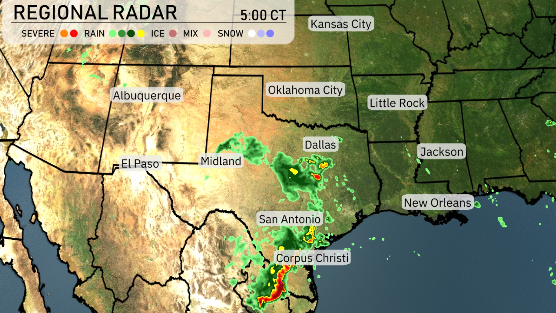
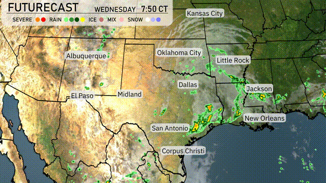
A storm system is making its way across the Southern Plains, with severe storms intensifying around Corpus Christi and San Antonio. Rain is stretching northward towards Dallas, as scattered showers pepper areas around Midland and Oklahoma City. El Paso and the surrounding regions maintain clear skies, providing a break in the precipitation. The rain system is anticipated to shift eastward, prompting cities like Little Rock and Jackson to prepare for incoming wet weather.
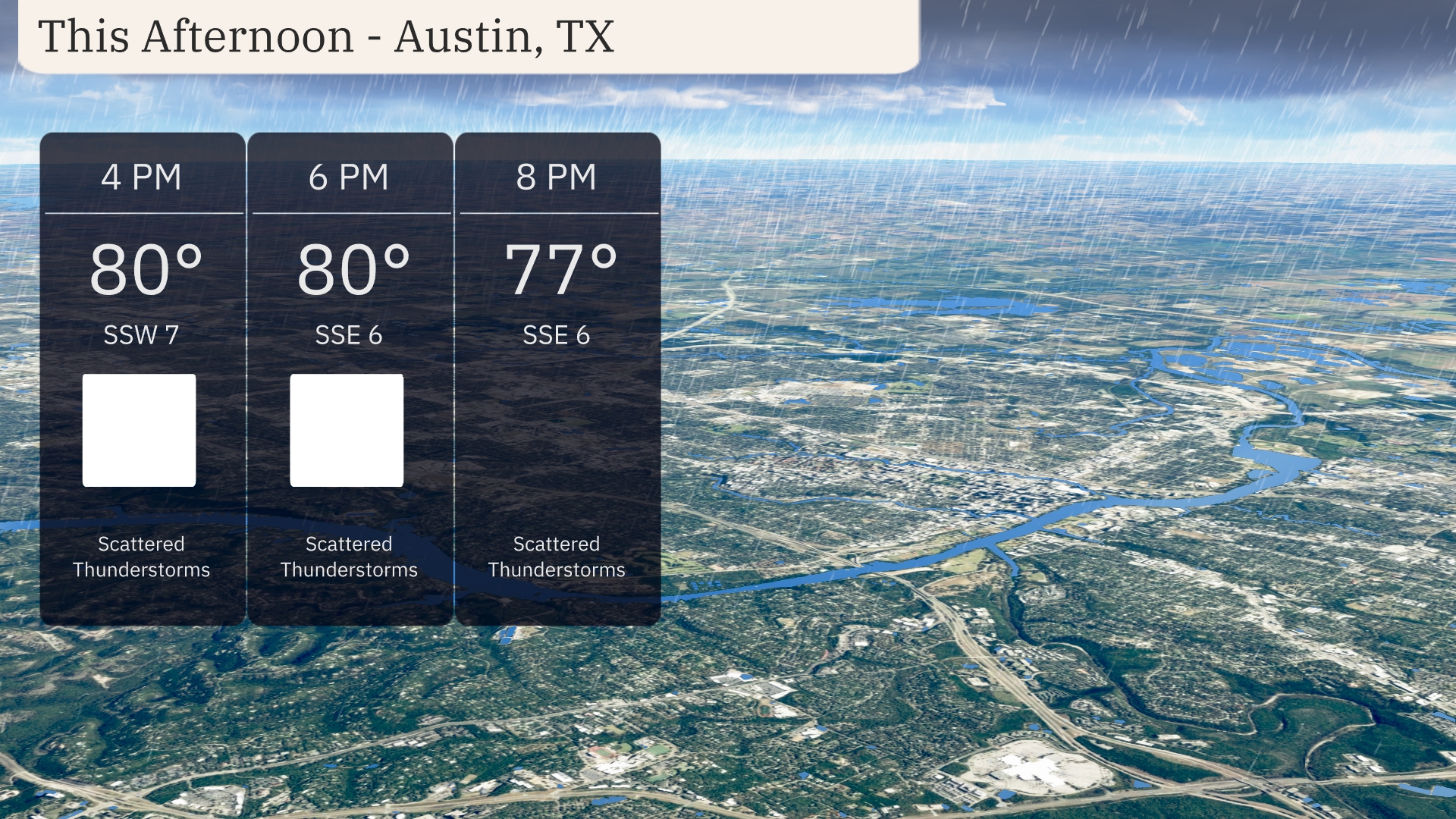
This afternoon in Austin, temperatures will remain steady around 80 degrees with scattered thunderstorms expected. Winds will be from the south-southwest at 7 miles per hour initially, shifting to 6 miles per hour from the south-southeast by 6 PM. Thunderstorms might bring some relief, but keep an umbrella handy if you’re out and about. Temperatures drop slightly to 77 degrees by 8 PM as showers continue.
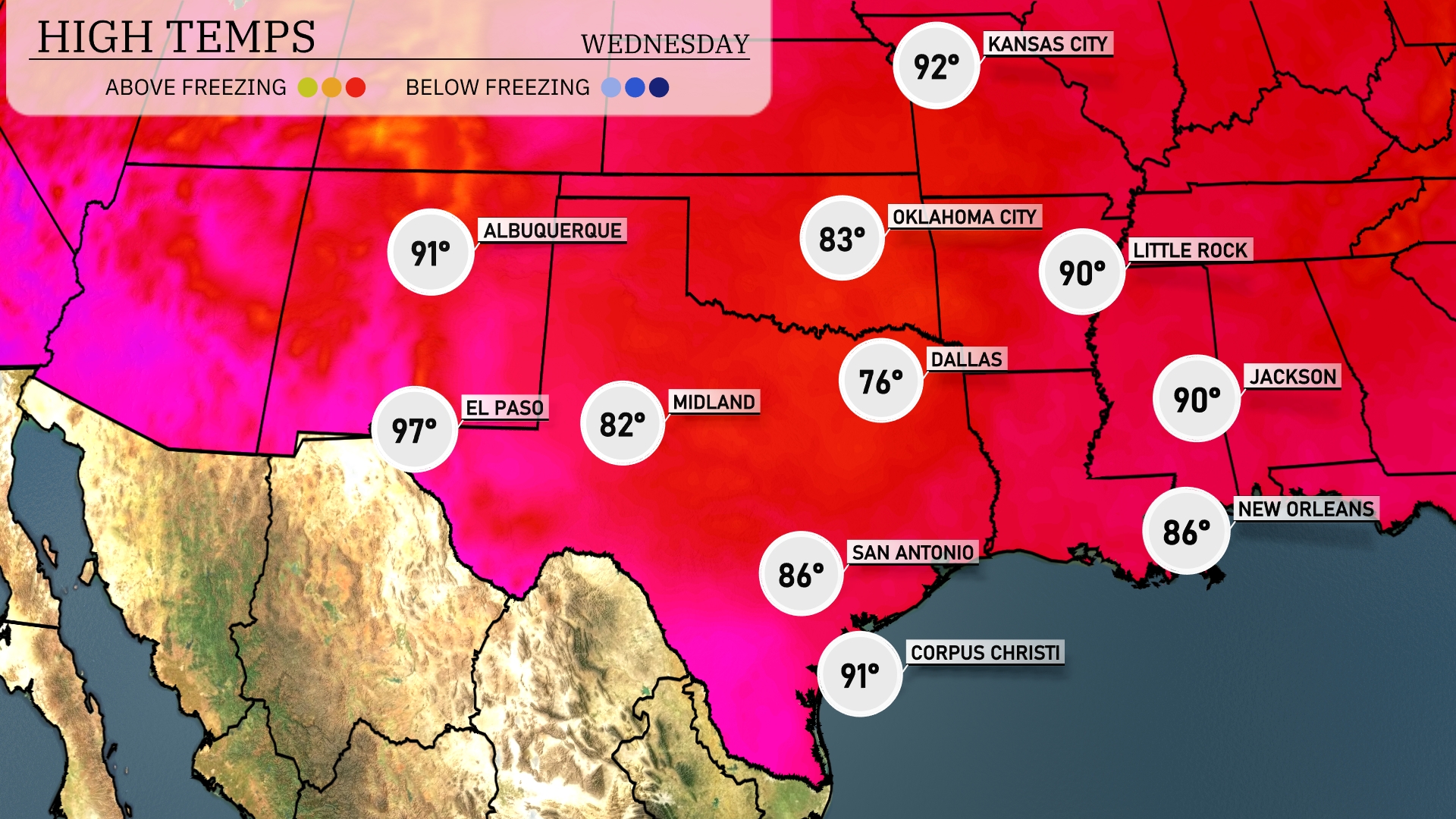
Today’s high temperatures in the Southern Plains are quite warm. In El Paso, expect a high of 97 degrees, while Midland will reach 82. Dallas will see a cooler high of 76, contrasting with the hot temperatures further west. San Antonio is forecasted to hit 86 degrees, and Corpus Christi will warm up to 91. In the east, New Orleans is at 86 degrees and Jackson is expected to reach 90.
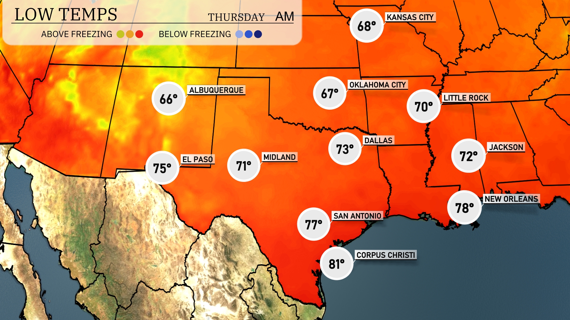
Tonight in the Southern Plains, Dallas will drop to a low of 73 degrees, while Midland cools to 71. Expect San Antonio to see a mild low of 77, with similar temperatures in New Orleans at 78. Los Alamos will cool to 66 degrees.
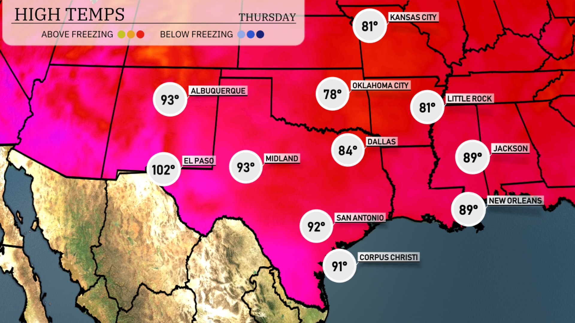
Tomorrow in El Paso, expect a scorching high of 102 degrees, well above average for this time of year. Midland will also feel the heat with a high reaching 93 degrees. San Antonio is set for a warm day at 92 degrees, while Corpus Christi will see a high of 91. Dallas will experience a more moderate temperature of 84 degrees, with Oklahoma City slightly cooler at 78. New Orleans and Jackson are likely to feel the warmth as well, both anticipating highs around 89 degrees.
A complex weather system is set to affect the Southern Plains tomorrow. Expect showers and possible thunderstorms from San Antonio to Corpus Christi, with heavier rain bands providing much-needed moisture. Oklahoma City is on alert for stronger storms, given the highly unstable air mass and an incoming cold front. Severe weather warnings may be necessary for the southeast, particularly east of Dallas. As the cold front progresses, anticipate a shift towards cooler and drier conditions late Wednesday.
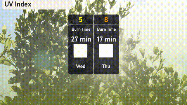
The UV index for Austin today is moderate at 5, with a burn time of approximately 27 minutes under direct sunlight. Plan for tomorrow as the index rises to 8, significantly increasing the risk of sunburn in just 17 minutes.