Navigating Through Austin’s Weather Patterns: Sunny Mornings to Stormy Evenings
By
Amy Freeze
Explore the meteorological shifts from sunny mornings to stormy nights across Austin and the Southern Plains, with expert insights from Amy Freeze.
Discover how Austin’s weather will shift from serene to stormy as we detail the upcoming weather patterns. Stay prepared with insights from Amy Freeze!
Dive into a detailed exploration of Austin’s weather through the week, with a keen focus on the transition from sunny mornings to potentially severe weather scenarios. Meteorologist Amy Freeze offers insights and safety measures for coping with high UV indexes and storm threats. Learn the nuances of regional weather patterns and how to stay safe in changing conditions.
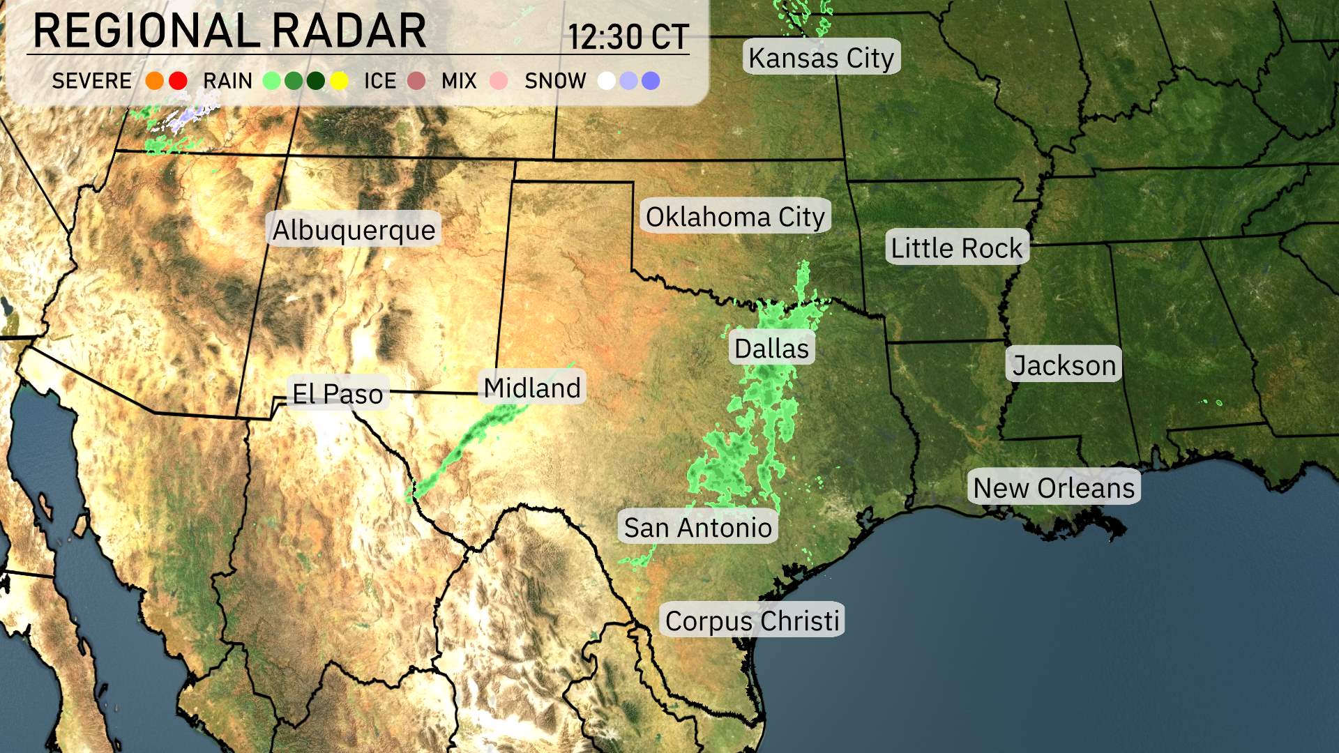
Across the Southern Plains, the radar shows mostly clear skies dominating much of the region. A narrow band of rain extends through central Texas, covering areas from Midland to Dallas, and moving eastward. El Paso and Albuquerque remain dry under sunny conditions, with similar clear skies stretching towards the northern area of Oklahoma City. San Antonio and Corpus Christi are experiencing ongoing rain showers, while Little Rock is enjoying clear skies for the moment. Further east, rain is developing as it strengthens toward the lower Mississippi Delta, impacting Jackson and New Orleans.
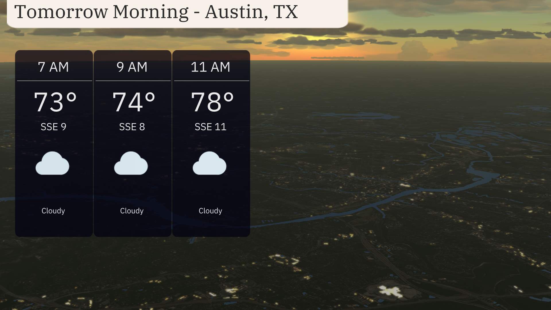
Tomorrow morning in Austin, expect cloudy skies throughout with temperatures rising steadily from 73 degrees at 7 AM to 78 degrees by 11 AM. Winds will be coming from the south-southeast, starting at 8 miles per hour and picking up slightly to 11 miles per hour as the morning progresses.
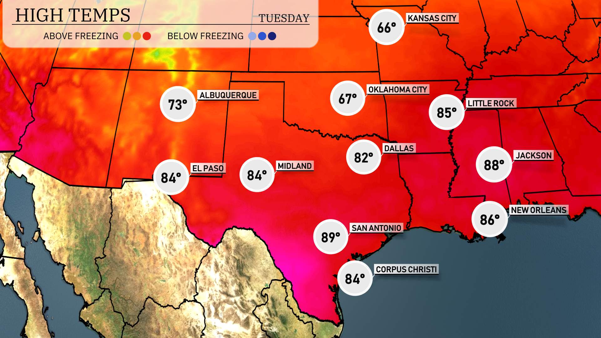
High temperatures for the Southern Plains tomorrow look warm and above average. San Antonio will see a high of 89 degrees, marking one of the warmest days in the region. Midland and El Paso aren’t far behind, with highs reaching 84 degrees each. Corpus Christi can also expect a comfortable 84 degrees, while Dallas will be slightly cooler at 82 degrees. Overall, expect a warm afternoon with clear conditions contributing to these higher temperatures.
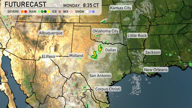
A dynamic weather pattern is setting up across the Southern Plains for tomorrow. Starting in the morning, scattered showers from Dallas to Corpus Christi will provide much-needed relief, while moving north towards Oklahoma City could see stronger storms by afternoon. With an unstable air mass ahead of an approaching cold front, severe weather risks, including high winds and possible hail, are notable throughout the region. The forecast calls for staying alert, particularly in southeastern Oklahoma through tomorrow night, as the threat of severe weather warnings remains elevated. As the cold front passes, expect cooler temperatures to follow and provide relief from the spring warmth.
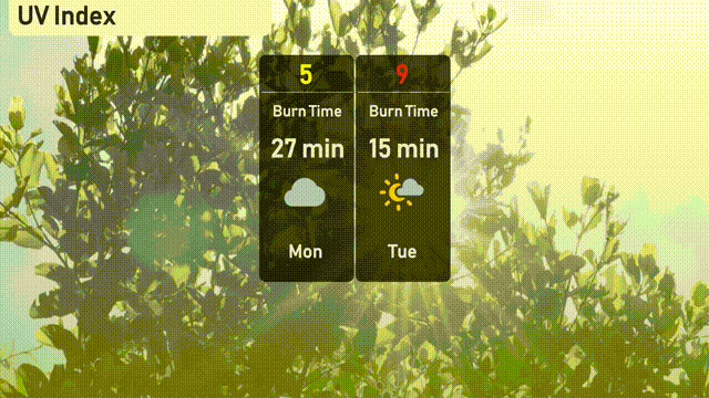
The UV index in Austin is moderate today, with a value of 5, indicating a burn time of about 27 minutes in direct sunlight. By Tuesday, it spikes to a very high level of 9, with a quicker burn time of 15 minutes. Be sure to utilize sun protective measures such as sunscreen, hats, and sunglasses if you plan to be outside. Stay attentive to UV levels to enjoy your time safely!
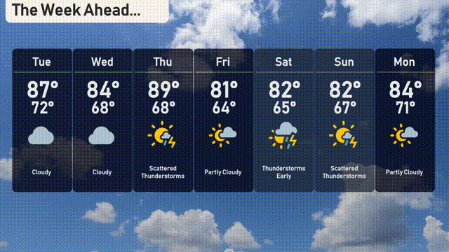
For the 7-day forecast in Austin:
Tuesday: Cloudy with a high of 87 degrees and a low of 72.
Wednesday: Cloudy again, with temperatures reaching 84 degrees and a low of 68.
Thursday: Look for scattered thunderstorms with a high of 89 degrees and a low of 68.
Friday: Partly cloudy with a high near 81 degrees, dipping to 64 at night.
Saturday: Early thunderstorms expected, highs around 82 degrees, and lows near 65.
Sunday: Scattered thunderstorms with highs reaching 82 degrees and a low of 67.
Monday: Partly cloudy skies with a daytime high of 84 degrees and a low of 71.
Enjoy your week, Austin!