Austin’s Afternoon Forecast: From Scattered Showers to Sunscreen
By
Amy Freeze
Explore today's Southern Plains weather - Austin heats up with sporadic showers and a UV challenge. Dive deep into our comprehensive analysis.
Today in Austin: Expect 88°F with cloudy skies, mild breezes, and scattered showers across the Southern Plains. Looking towards a warm night and an even warmer tomorrow!
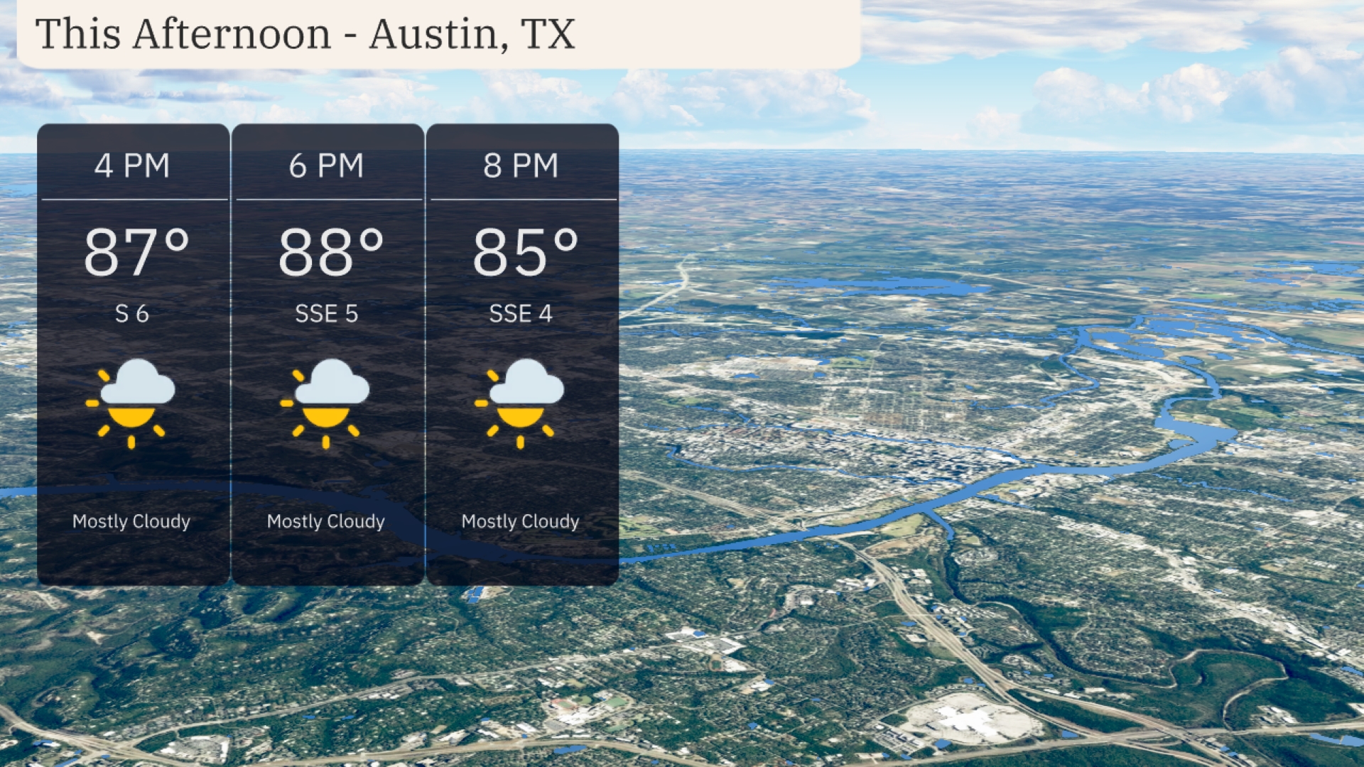
Austin greets us with partly cloudy skies, reaching up to 88 degrees this afternoon. A mild breeze softens the warm push with scattered rain showers noted from Midland to San Antonio. The entire Southern Plains basks under summer warmth, indicating a typical summer day with temperatures peaking at 100 degrees in El Paso. As night falls, temperatures mildly dip. Prepare for an active weather pattern tomorrow and remember to stay protected under extreme UV levels. Detailed daily forecasts for the week also included to keep you updated!
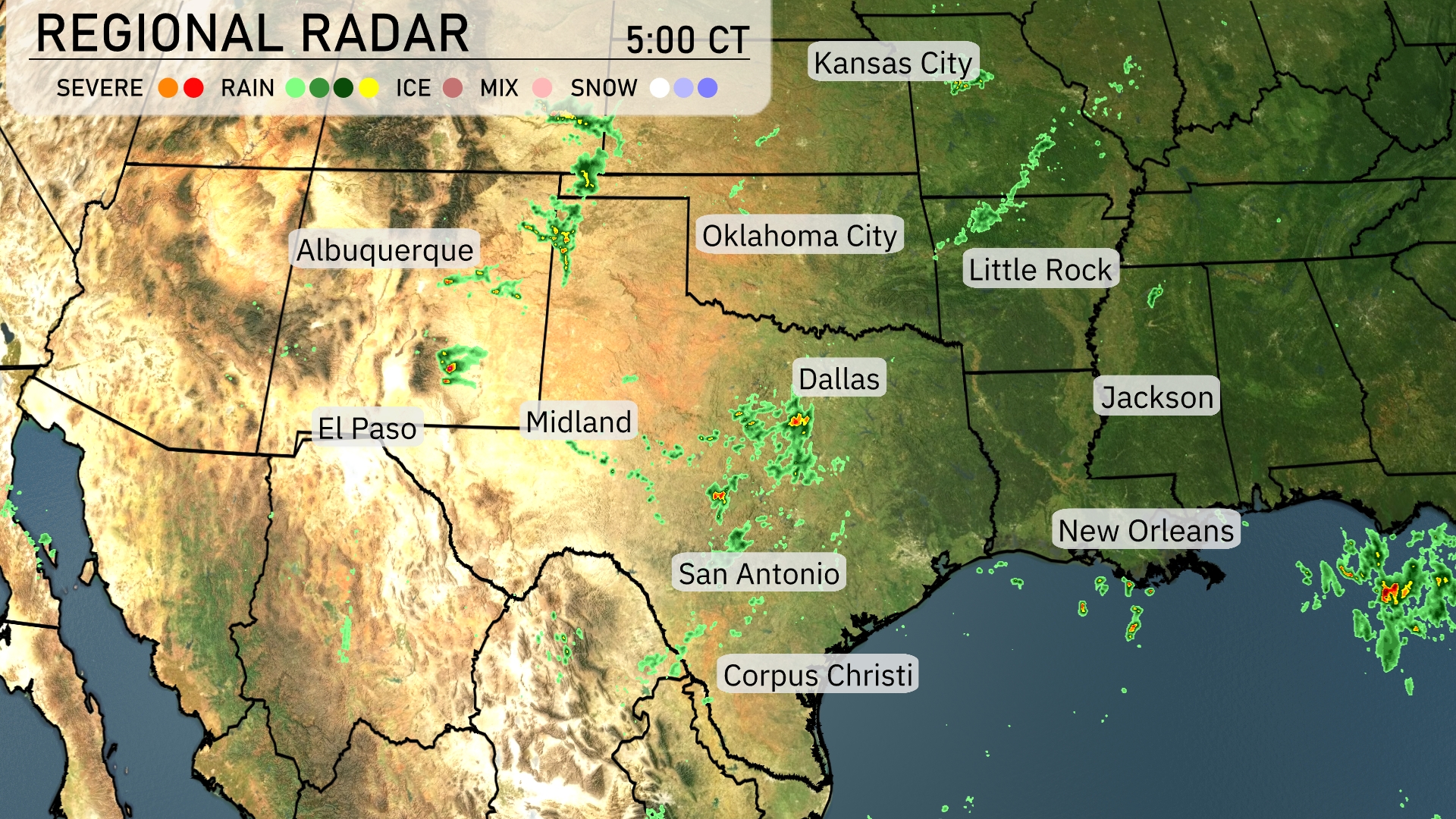
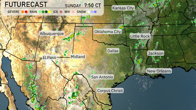
On the Regional Radar, there’s a scattered cluster of rain showers stretching from Midland to San Antonio, moving northeastward. Dallas is currently experiencing light rain, with some potential for isolated thunderstorms. Meanwhile, showers are also developing near the southern border of Oklahoma, tracking towards Oklahoma City. Areas like New Orleans are seeing increasing cloud cover as moisture gathers in the Gulf.
Afternoon temperatures in Austin reach up to 88 degrees with a mostly cloudy sky. A mild breeze from the south to southeast at around 5 mph keeps the air moving. Cloud cover provides a little relief from direct sunlight, although it’s still warm. Temperatures ease slightly to 85 degrees by 8 PM as the wind calms to 4 mph.
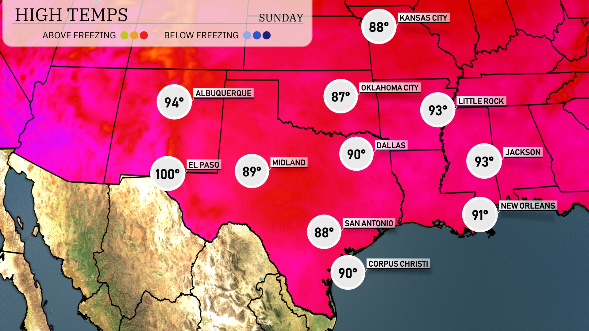
Today’s high temperatures are soaring across the Southern Plains. El Paso is leading the pack with a scorching 100 degrees, while Midland reaches a warm 89. In Dallas, expect a high of 90 degrees, with San Antonio slightly cooler at 88. Meanwhile, Oklahoma City sits at 87, and Little Rock is not far behind at 93. The region is experiencing significant warmth today, making it a typical summer day in the South.
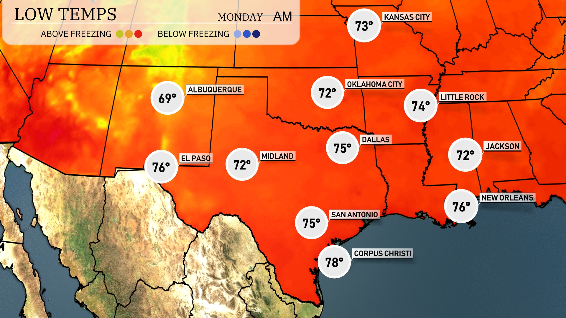
Tonight, Dallas will cool down to 75 degrees, while San Antonio will also experience a low of 75. Expect a mild night in Austin at 76 degrees, with New Orleans dropping slightly to 76 as well. Meanwhile, Corpus Christi will remain warm at 78 degrees, marking one of the higher overnight lows in the region.
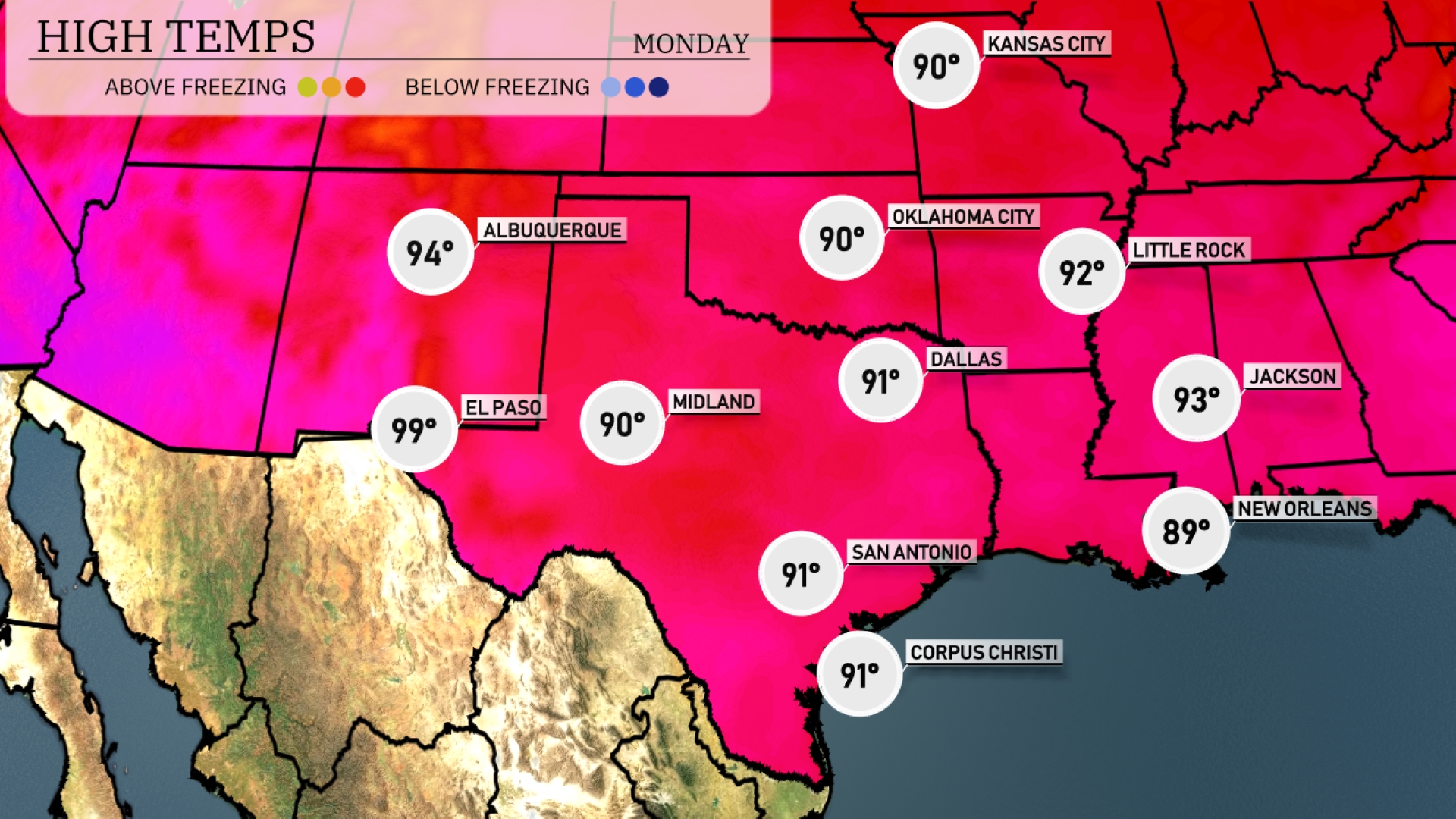
Tomorrow, El Paso will reach a scorching 99 degrees, while Midland will see a high of 90. San Antonio is expected to hit 91 degrees, and Dallas will warm up to 91 as well. In Jackson, highs will be around 93 degrees, with New Orleans slightly cooler at 89. Overall, many areas in the Southern Plains are trending above average as high pressure influences warmer temperatures across the region.
Expect an active weather pattern in the Southern Plains tomorrow. Showers and thunderstorms are likely from Dallas to San Antonio, with the potential for heavier storms reaching Oklahoma City. As a cold front approaches, there’s a risk of severe weather, particularly in southeastern areas, into Wednesday. Keep an eye out for possible warnings. Temperatures will be cooler post-front, but dry and clear conditions should settle in by mid-week.
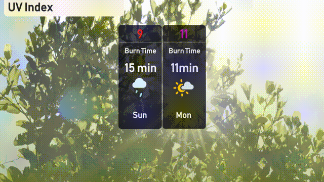
The UV index in Austin today is set to be 9, meaning sun protection is essential as burn time is about 15 minutes during sunlight breaks amidst potential showers. Tomorrow, expect an extreme UV level of 11 with a burn time of just 11 minutes, so lather up on sunscreen and wear hats and sunglasses! Stay sun-safe!