Evening Breezes and Sizzling Days: Your Austin Weather Guide
By
Amy Freeze
From clear evening skies in Austin to anticipated storms in the Southern Plains, read on to discover how this week’s weather will shape up in your neighborhood!
Discover what the weather has in store for Austin and its neighbors! Clear skies, rising temperatures, and potential storms—get all the insights in our detailed guide.
As you step out in Austin this evening, enjoy the calm and clear skies with temperatures gently falling. But don’t let the serene night fool you—hot days are on the horizon with temperatures climbing into the mid-high 90s. A cold front approaching will stir up temperatures and potentially bring severe weather conditions. Read our full analysis on what these changes mean for your daily plans and how you can stay prepared for the weather ahead!
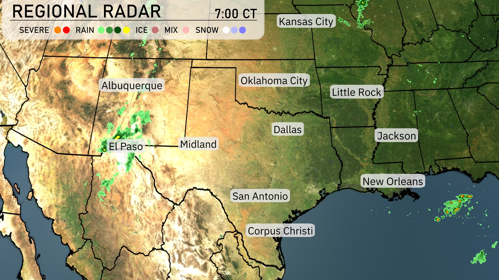
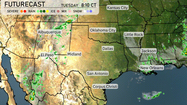
Cloud cover and rain showers are evident near El Paso, spreading into southern New Mexico. Even though severe weather isn’t a main feature on today’s radar, these showers should gradually move eastward toward Midland by later today. Parts of the Gulf Coast near New Orleans show some precipitation moving over the water, hinting at cloudy conditions. Otherwise, from Dallas moving into Oklahoma City, clear skies prevail with no significant weather to report at this time.
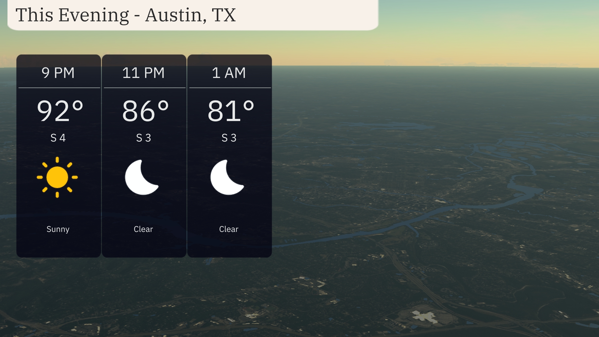
In Austin for this evening, expect clear skies with temperatures gradually dropping from 92 degrees at 9 PM to 81 degrees by 1 AM. Winds will be calm, coming from the south at around 3 to 4 miles per hour. It’s a great evening for outdoor activities as high pressure maintains stability in the area.
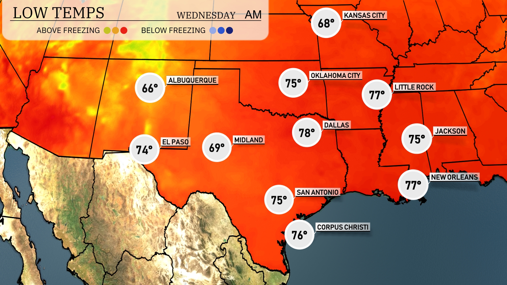
Tonight, temperatures will drop to 69 degrees in Midland, while El Paso will be slightly warmer at 74 degrees. Dallas will see a low of 78 degrees, and San Antonio will cool down to 75. The evening will bring lows of 75 in Jackson and 77 in New Orleans, indicating a mild night across the Southern Plains region.
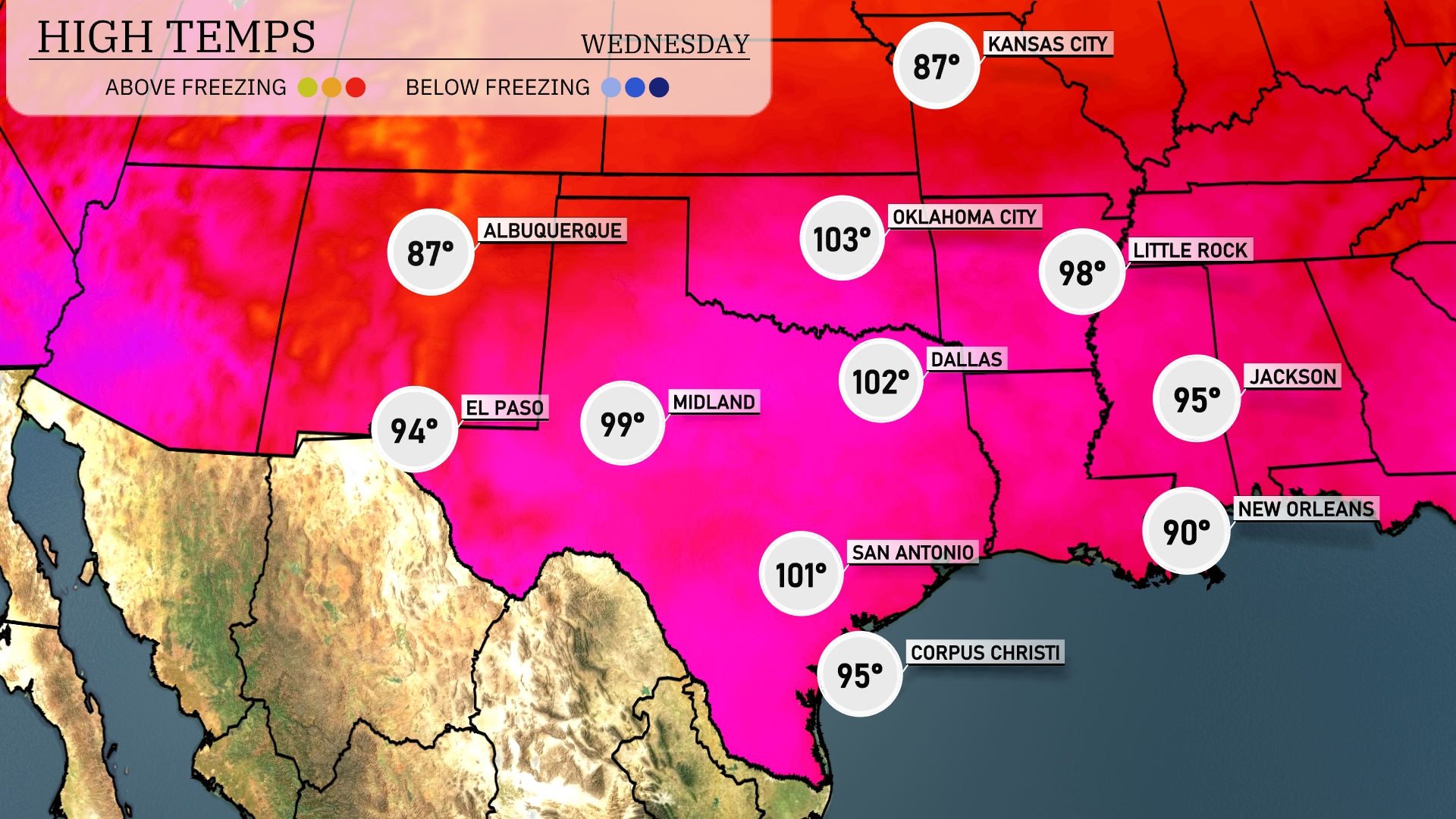
Tomorrow in the Southern Plains, El Paso will see a high of 94 degrees, while Midland heats up to 99. Dallas is expected to reach 102 degrees, and San Antonio will be all the way up at 101. New Orleans can expect a warm day with a high of 90 degrees, and Little Rock will hit 98. These temperatures are running above normal for this time of year, influenced by a persistent warm front moving through the region.
A cold front approaches the Southern Plains tomorrow, stirring up the atmosphere with rain and storms extending from Dallas down to Corpus Christi. Temperatures in Oklahoma City may drop as this system passes, but not before sparking strong storms. Keep an eye out for severe weather warnings as the air mass becomes unstable, especially across Southeastern Oklahoma into Northern Texas. Rainfall will bring relief to some drought-stricken areas but may lead to localized flooding with heavy downpours. Be prepared for cooler air post-front, setting a chillier tone for the latter part of the week.
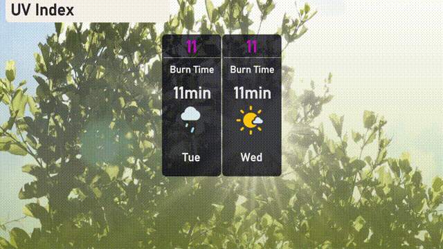
The UV index in Austin is extremely high at 11 for both Tuesday and Wednesday, with a quick burn time of just 11 minutes. It’s crucial to limit direct sun exposure, seek shade, and use sunscreen liberally. Stay protected during outdoor activities!
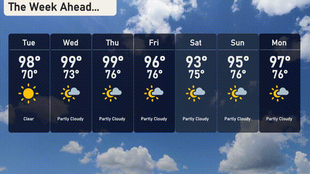
For the 7-day forecast in Austin:
Tuesday: Clear skies with a high of 98 degrees and a low of 70 degrees.
Wednesday: Partly cloudy, warming up to 99 degrees, with a low of 73 degrees.
Thursday: Another partly cloudy day reaching 99 degrees for a high, cooling to 76 at night.
Friday: Temperatures ease slightly with mostly cloudy conditions and a high of 96 degrees, a low of 76 degrees.
Saturday: Partly cloudy, cooler with a high of 93 degrees, dipping to 75 degrees overnight.
Sunday: Maintaining partly cloudy skies with temperatures rising to 95 degrees, with lows around 76 degrees.
Monday: Partly cloudy, with highs warming back to 97 degrees and lows of 76 degrees.