Storm Watch: Navigating Austin’s Weather Wonders and Woes
By
Amy Freeze
Explore the shifting skies over Austin and beyond as we brace for storms. Get your comprehensive guide to this week's weather trends across the Southern Plains.
This week in Austin, prepare for a rollercoaster of weather conditions, from balmy afternoons to stormy evenings. Our latest blog walks you through each day’s forecast!
Austin and the Southern Plains are seeing a dynamic shift in weather this week. With storms forecasted to sweep through the region, bringing potential severe conditions, it’s crucial to stay updated. Our blog provides a detailed break-down for Austin, from today’s calming skies to the intense storm systems set for the week. Don’t miss out on expert tips for weatherproofing your plans!
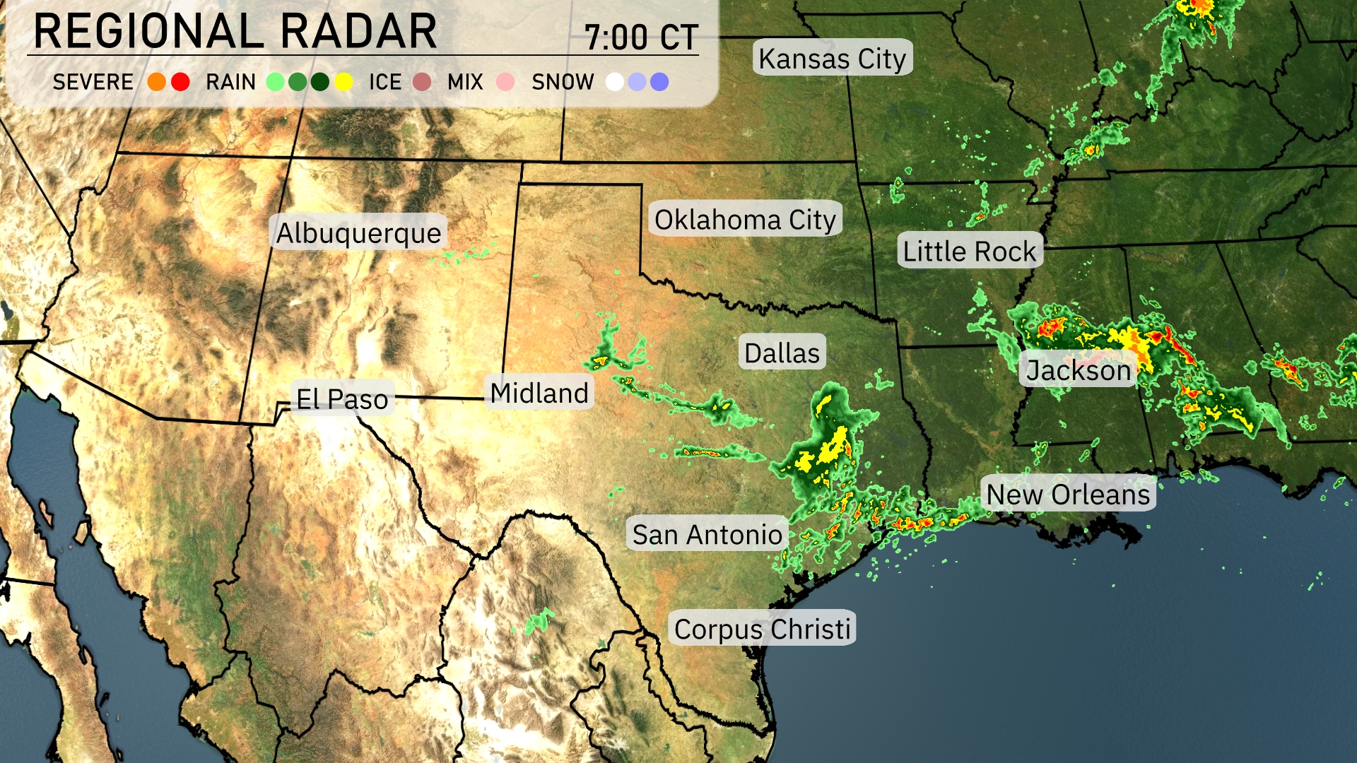
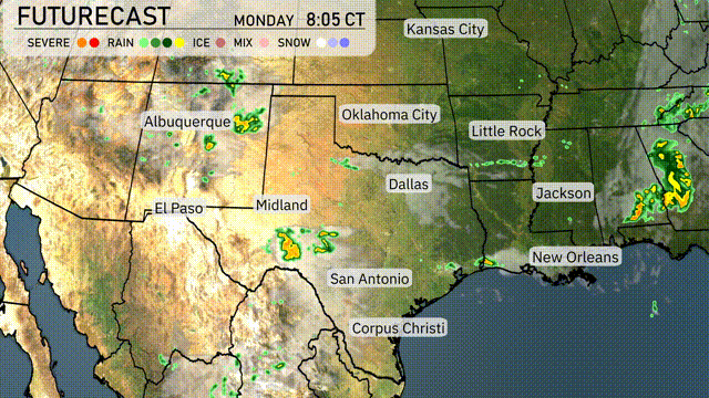
Across the Southern Plains, clear skies dominate much of the region, offering a peaceful start to the day. However, showers are passing through central Texas, especially near San Antonio, moving towards the Gulf Coast. Parts of eastern Louisiana, stretching towards Jackson, Mississippi, are experiencing steady rain. Elsewhere, the radar is quiet, providing dry conditions from Dallas to El Paso.
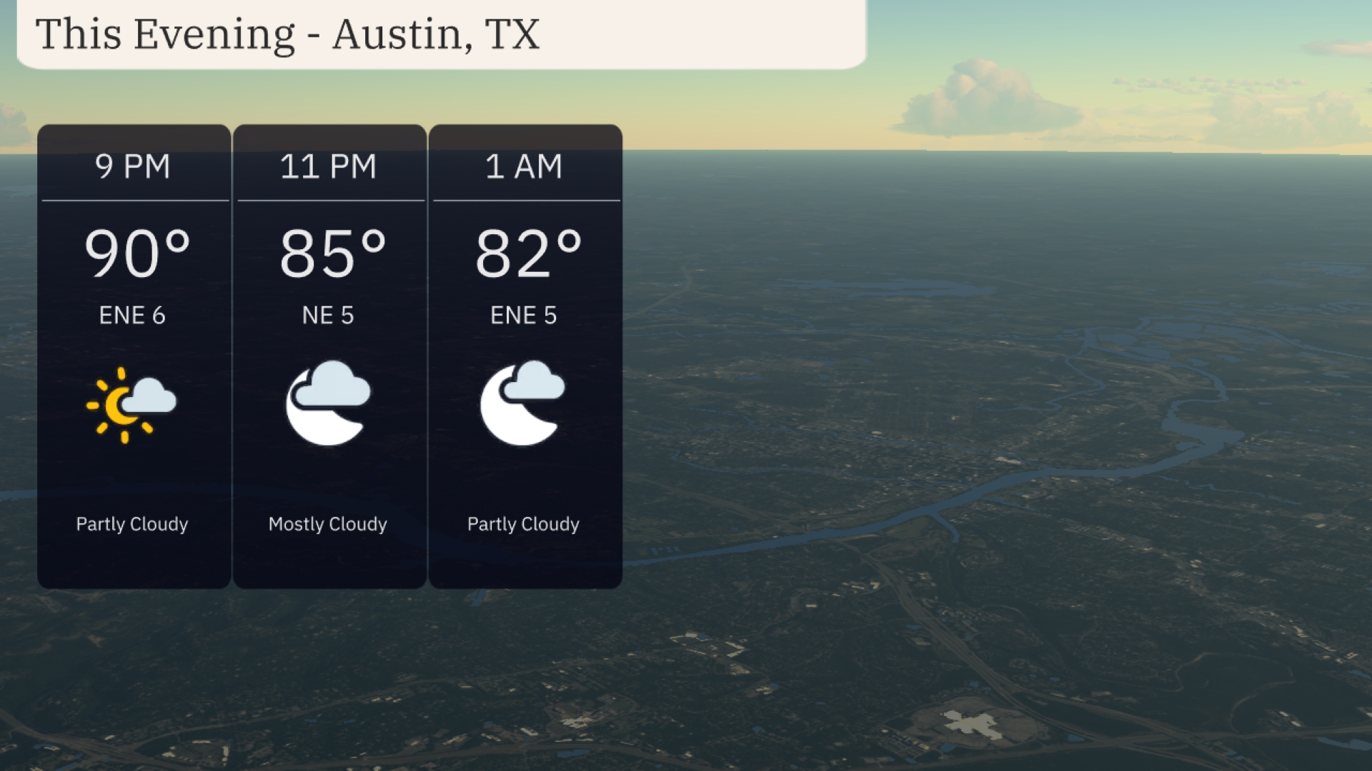
For this evening in Austin, enjoy a partly cloudy sky with temperatures starting at 90 degrees at 9 PM. By 11 PM, temperatures will ease to 85 degrees, with mostly cloudy conditions taking over. Expect a gentle breeze, with the wind shifting slightly from east-northeast at 6 miles per hour to east-northeast at 5 miles per hour by midnight. Temperatures continue to dip to 82 degrees at 1 AM under partly cloudy skies.
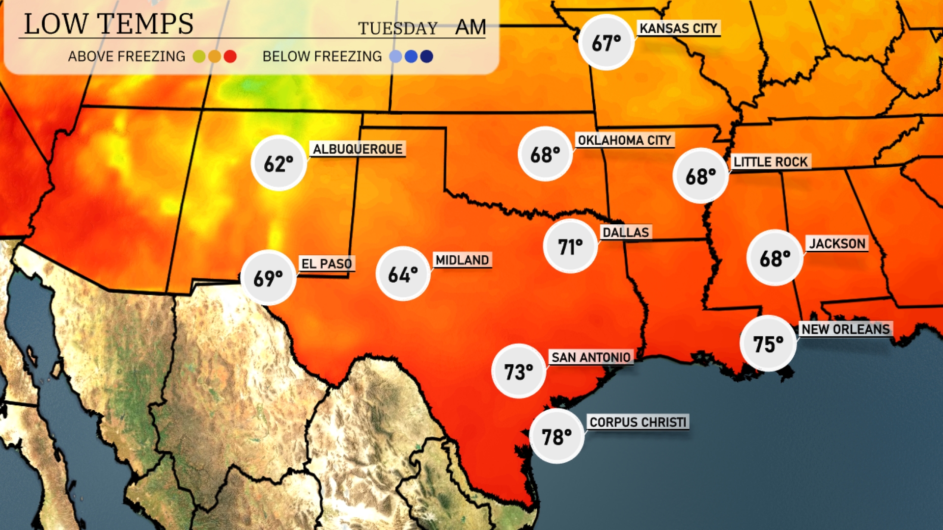
Tonight Dallas will hover around 71 degrees, while San Antonio sits slightly warmer at 73. Expect a low of 68 in Little Rock and 67 in Oklahoma City. El Paso will cool down to 69 degrees, maintaining a pleasant evening across the region.
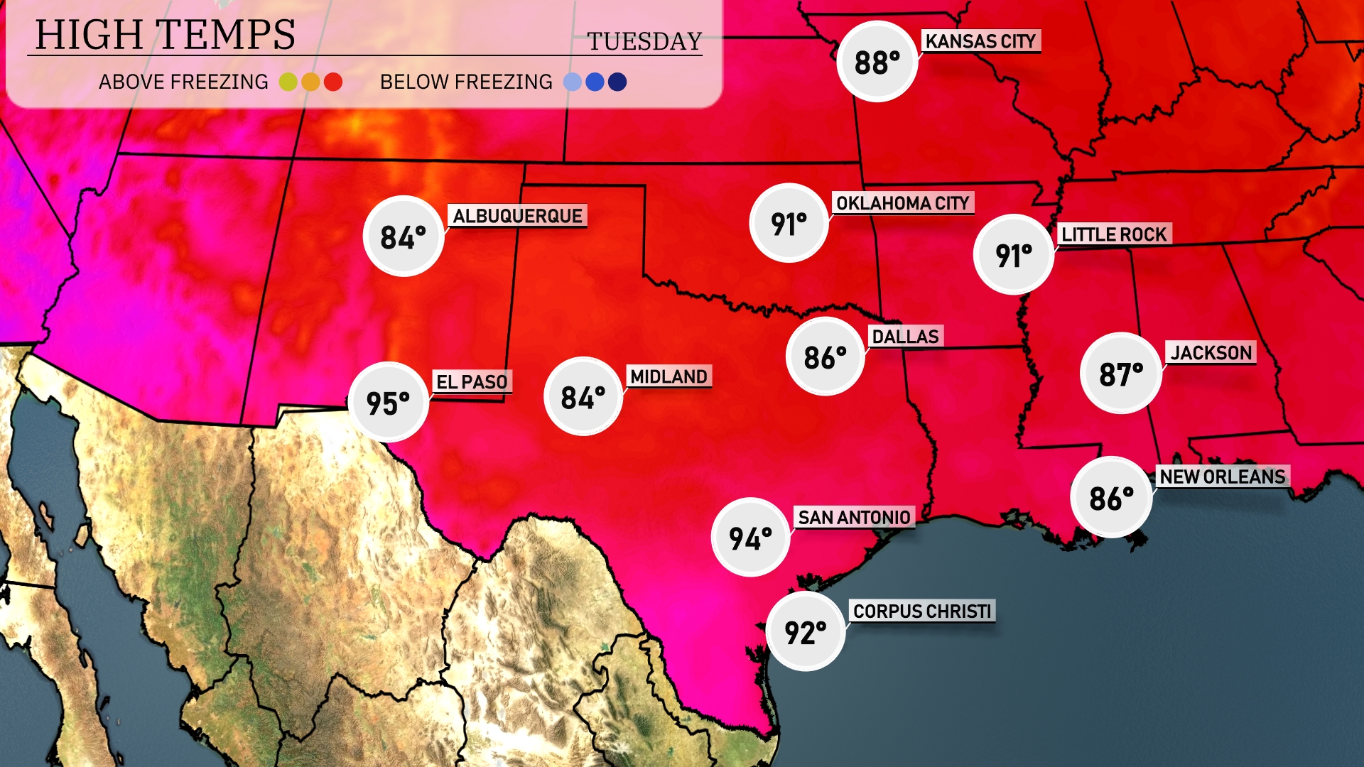
Tomorrow, El Paso is set to sizzle with a high of 95 degrees, showcasing a continued warm trend for the area. Midland will see slightly cooler temperatures at 84 degrees. In San Antonio, expect a steamy high of 94 degrees, while Corpus Christi will reach 92 degrees. Dallas will share similar warmth at 86 degrees, and Little Rock anticipates reaching a high of 91 degrees.
A strong cold front is expected to push through the Southern Plains from west to east tomorrow, bringing widespread thunderstorms from Dallas to Oklahoma City. Embedded within these storms, there is a potential for severe weather, including damaging winds and hail, particularly across eastern Oklahoma and north Texas. Rain will sweep across regions from San Antonio to Corpus Christi, supplying beneficial moisture. However, heavy rainfall could lead to flooding, especially in more urban areas. Temperatures are set to drop following the front’s passage, with cooler, drier conditions arriving by late Wednesday.
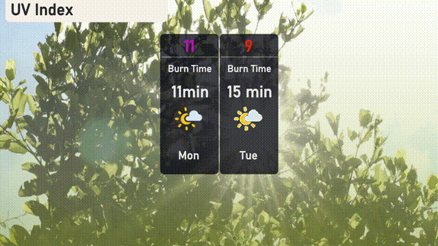
The UV index in Austin will reach an extreme level of 11 on Monday, leading to a burn time of just 11 minutes, so protective measures are a must! By Tuesday, it decreases to 9 with a burn time of about 15 minutes.
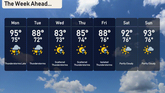
For the 7 Day Outlook in Austin:
Monday: Expect thunderstorms late with a high of 95 degrees and a low of 75 degrees.
Tuesday: Thunderstorms continue with a cooler high of 88 degrees and a low of 72 degrees.
Wednesday: Scattered thunderstorms with a high of 83 degrees and a low of 73 degrees.
Thursday: Thunderstorms persist, peaking at 85 degrees and easing to 74 degrees overnight.
Friday: Isolated thunderstorms with highs around 88 degrees and lows of 76 degrees.
Saturday: Partly cloudy skies with temperatures reaching 92 degrees during the day and a low of 76 degrees.
Sunday: Partly cloudy once again with a high of 93 degrees and a low of 76 degrees.