Weather Whirl: Sunny Days and Stormy Nights in Austin
By
Amy Freeze
This week in Austin and the Southern Plains, expect a rollercoaster of weather conditions from thunderstorms to sunny highs. Get the detailed forecast!
Dive into our latest blog post for a comprehensive look at this week’s fluctuating weather patterns across Austin and the Southern Plains. From brisk sunny days to impending thunderstorms, know what to expect as we guide you through each day’s conditions.
In this week’s weather blog, we explore the dynamic and varying conditions across Austin and the Southern Plains. From evening temperatures starting at 89 degrees and dipping to cooler nights, to sudden thunderstorms near El Paso and mild sunny days reaching highs of up to 97 degrees, we cover it all. Additionally, we discuss potential severe storms and the direct effect of a cold front bringing widespread showers.
Saturday to Friday, each day holds its unique pattern, impacting both locals and visitors. Make sure to stay prepared with our weather insights and tips as we brace for an energetic weather week.
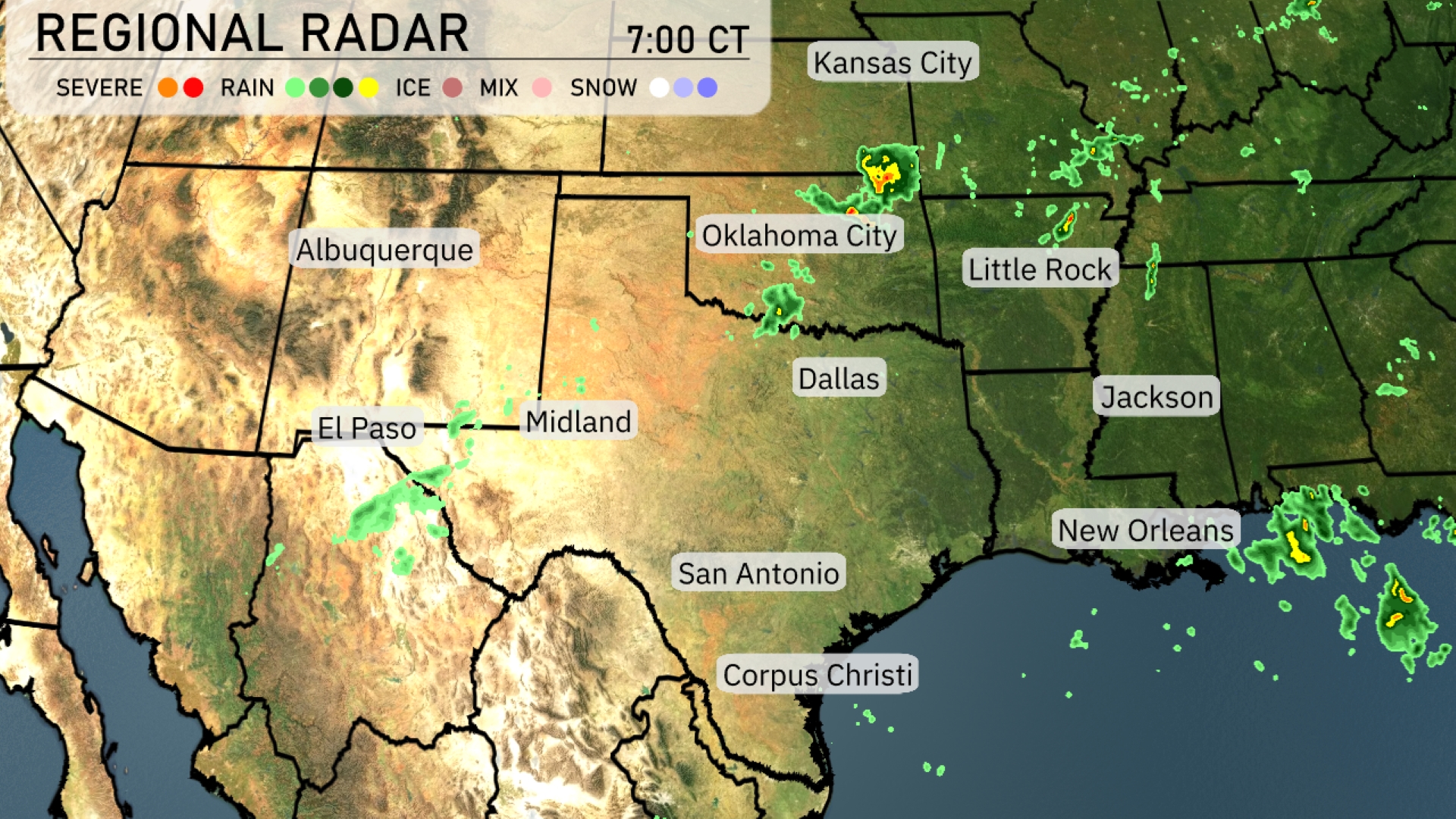
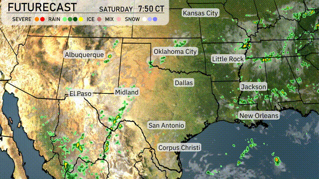
On the Regional Radar for the Southern Plains, thunderstorms are intensifying near the Mexico border, just west of El Paso. Rain showers are also popping up around Midland, Texas, drifting slowly towards Dallas. Oklahoma City is seeing isolated showers with cloud cover extending into southern Kansas. Scattered showers and some storm activity are projected across Louisiana, moving towards the region near New Orleans.
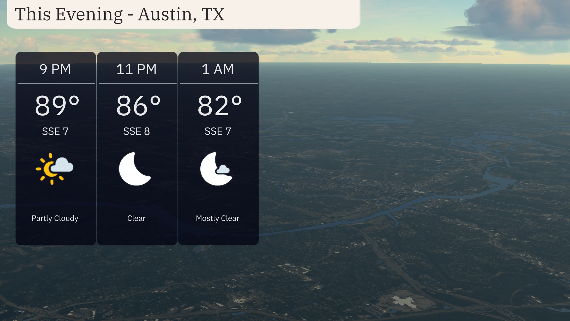
Evening temperatures in Austin begin at 89 degrees, dipping to 82 degrees by 1 AM. You’ll experience partly cloudy skies at 9 PM, transitioning to clear conditions as the night progresses. Winds will be from the south-southeast at 7 to 8 miles per hour, maintaining a gentle breeze through the evening.
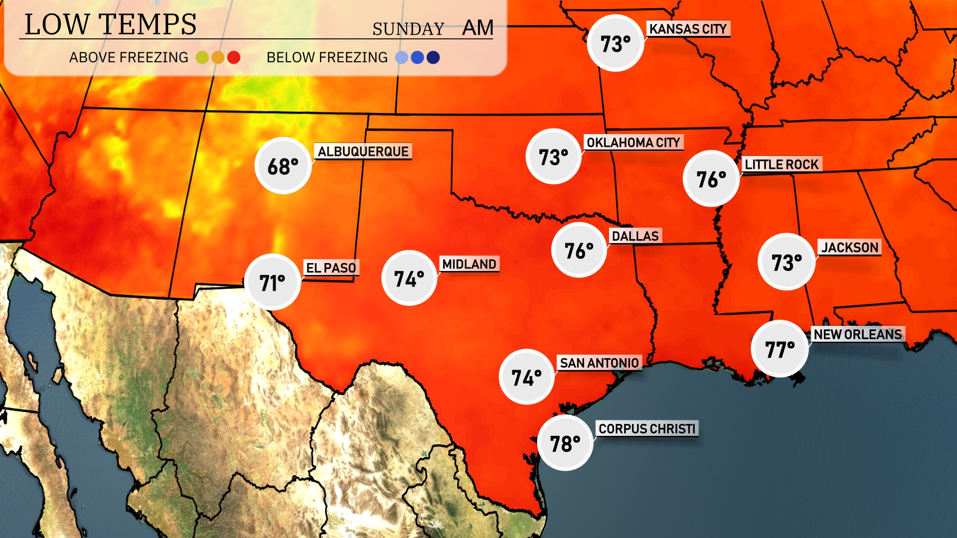
Tonight in the Southern Plains, temperatures will be mild but cooler than previous nights. Amarillo will drop to a low of 68 degrees. Expect 71 degrees in El Paso and 74 in Midland. San Antonio will also see a low of 74 degrees, while Dallas cools down to 76.
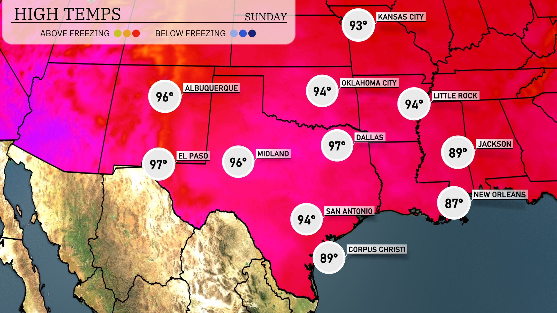
Tomorrow in the Southern Plains, El Paso is set to soar to a high of 97 degrees. Midland will experience slightly cooler conditions with a high of 96 degrees. Over in Dallas, expect temperatures to touch 97 degrees as well. San Antonio is looking at a warm 94 degrees, while Corpus Christi will be more moderate at 89 degrees.
A cold front makes its way across the Southern Plains tomorrow, bringing widespread showers and thunderstorms from Dallas to Little Rock. Oklahoma City should be on alert for potential severe storms, possibly featuring damaging winds and heavy rainfall. Areas around Corpus Christi can anticipate beneficial rain, which could help alleviate dry conditions. The front moves eastward, leaving behind cooler temperatures towards Wednesday, but with lingering storm chances in southeast Texas. Be prepared for changing weather conditions and possible alerts through the day.
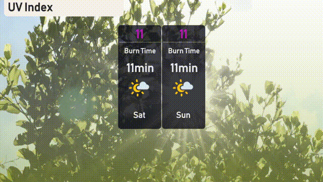
The UV index in Austin will reach an extreme level of 11 both today and tomorrow, with a rapid burn time of 11 minutes in direct sunlight.
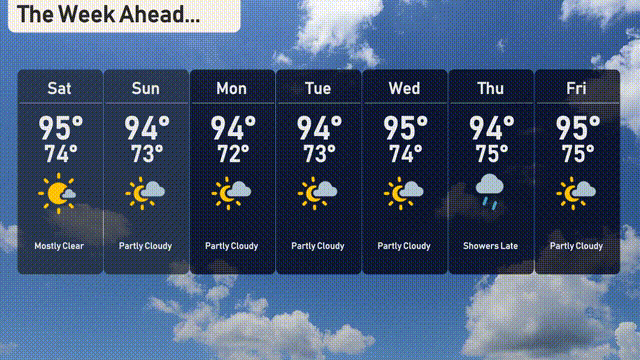
Saturday: The week kicks off with mostly clear skies and a warm high of 95 degrees, dropping to 74 degrees at night.
Sunday: Expect partly cloudy conditions with a high reaching 94 degrees and a low of 73 degrees.
Monday: More clouds rolling in, but the temperature remains steady with a high of 94 degrees and a low of 72 degrees.
Tuesday: Partly cloudy again, looking at a high of 94 degrees, cooling to 73 degrees overnight.
Wednesday: Similar conditions continue with a partly cloudy high of 95 degrees and a low of 74 degrees.
Thursday: Showers expected to arrive late in the day with a high of 94 degrees and a night-time low of 75 degrees.
Friday: The week concludes with partly cloudy skies and a high of 95 degrees, dipping to 75 degrees overnight.