Austin’s Sizzling Sunday: Your Comprehensive Weather Guide
By
Amy Freeze
From severe storms to scorching highs, delve into what this week holds for Austin’s weather with in-depth insights and protective measures against extreme UV levels.
This week, Austin is heating up with temperatures soaring to the 90s. Meanwhile, don’t miss out on preparing for the anticipated severe storms. We’ve also got essential tips for handling extreme UV exposure!
Covering all aspects from the ongoing heatwave in Austin to the significant weather shifts courtesy of a cold front, our latest post unpacks the Southern Plains’ weather in detail. Learn how the UV index at an extreme level impacts your daily activities and discover protective measures to adopt. Explore the climatic nuances and prepare your week with our forecast!
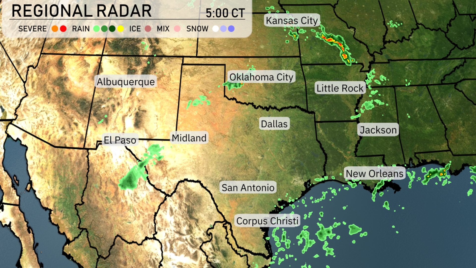
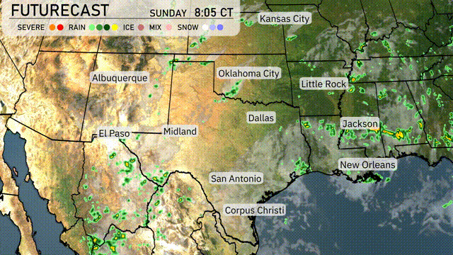
A line of severe storms is advancing through the Southern Plains, moving across southern Kansas towards Kansas City. Light rain showers are noted in central Texas near Midland, moving eastward. Scattered showers can also be seen moving east near Jackson, Mississippi, and extending out towards New Orleans. Meanwhile, areas like El Paso and San Antonio enjoy drier, clearer conditions under calm skies.
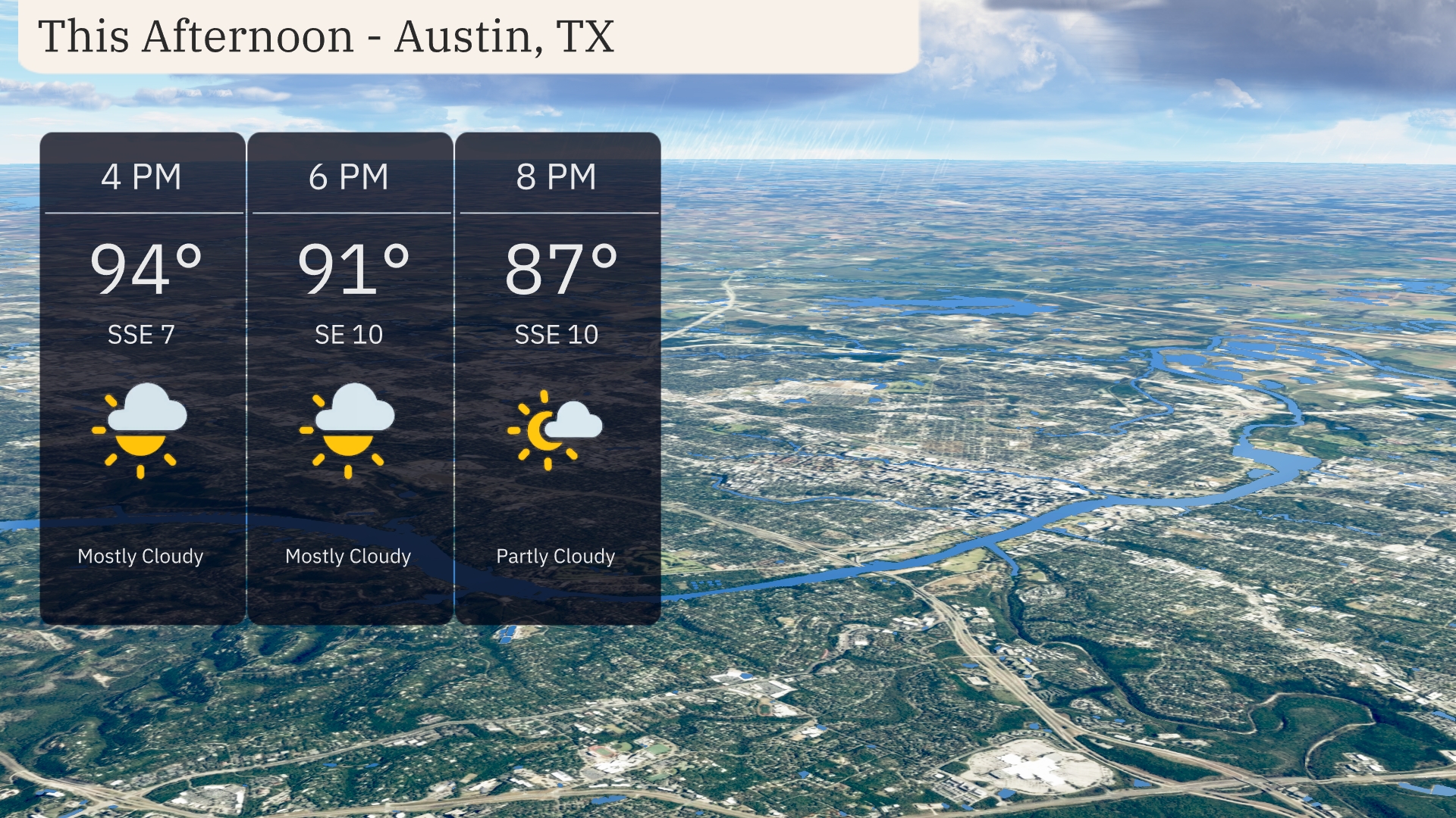
Austin temperatures this afternoon start at 94 degrees at 4 PM, dipping to 91 degrees by 6 PM. Winds are coming from the south-southeast at 7 to 10 mph. Mostly cloudy skies will dominate through the early evening, transitioning to partly cloudy conditions by 8 PM with temperatures around 87 degrees.
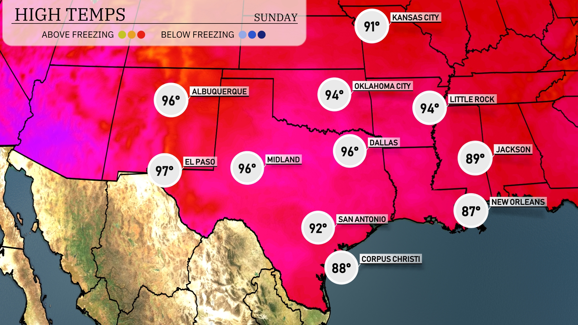
Afternoon highs across the Southern Plains are sizzling today. In El Paso, expect a high of 97 degrees, while Midland also sees similar heat with a high of 96. Dallas will warm up to 96 degrees, bringing a hot day to the area. San Antonio is slightly cooler at 92 degrees, with a bit of relief from the higher temps. In contrast, New Orleans is experiencing more moderate conditions with a high of 87 degrees, making it a more pleasant day by the Gulf.
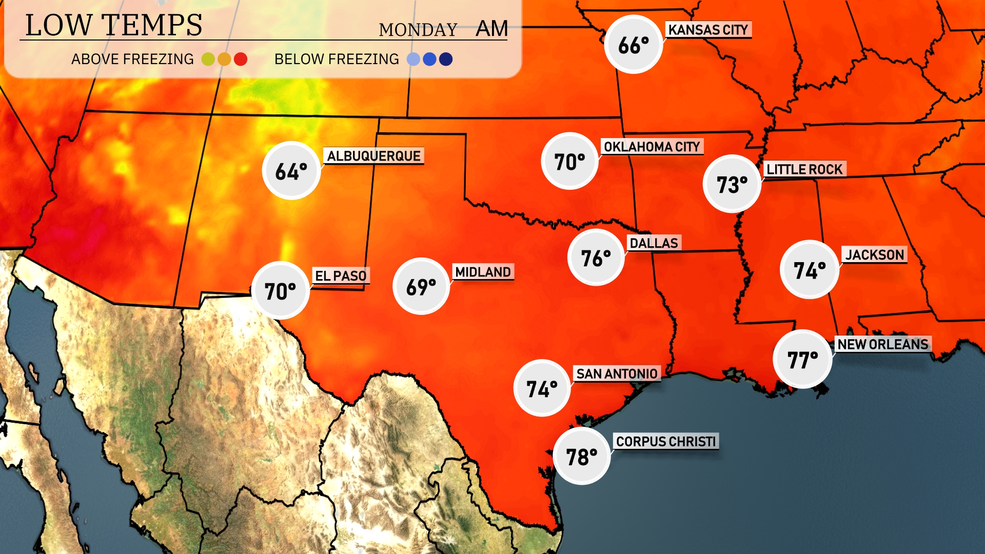
Tonight in the Southern Plains, lows will be mild but variable. Dallas is expected to cool down to 76 degrees, while Midland will see a low of 69. San Antonio is forecasting a low of 74, and Jackson should drop to 74 degrees as well. Expect temperatures to remain relatively warm across the region, with no significant cold air pushing through tonight.
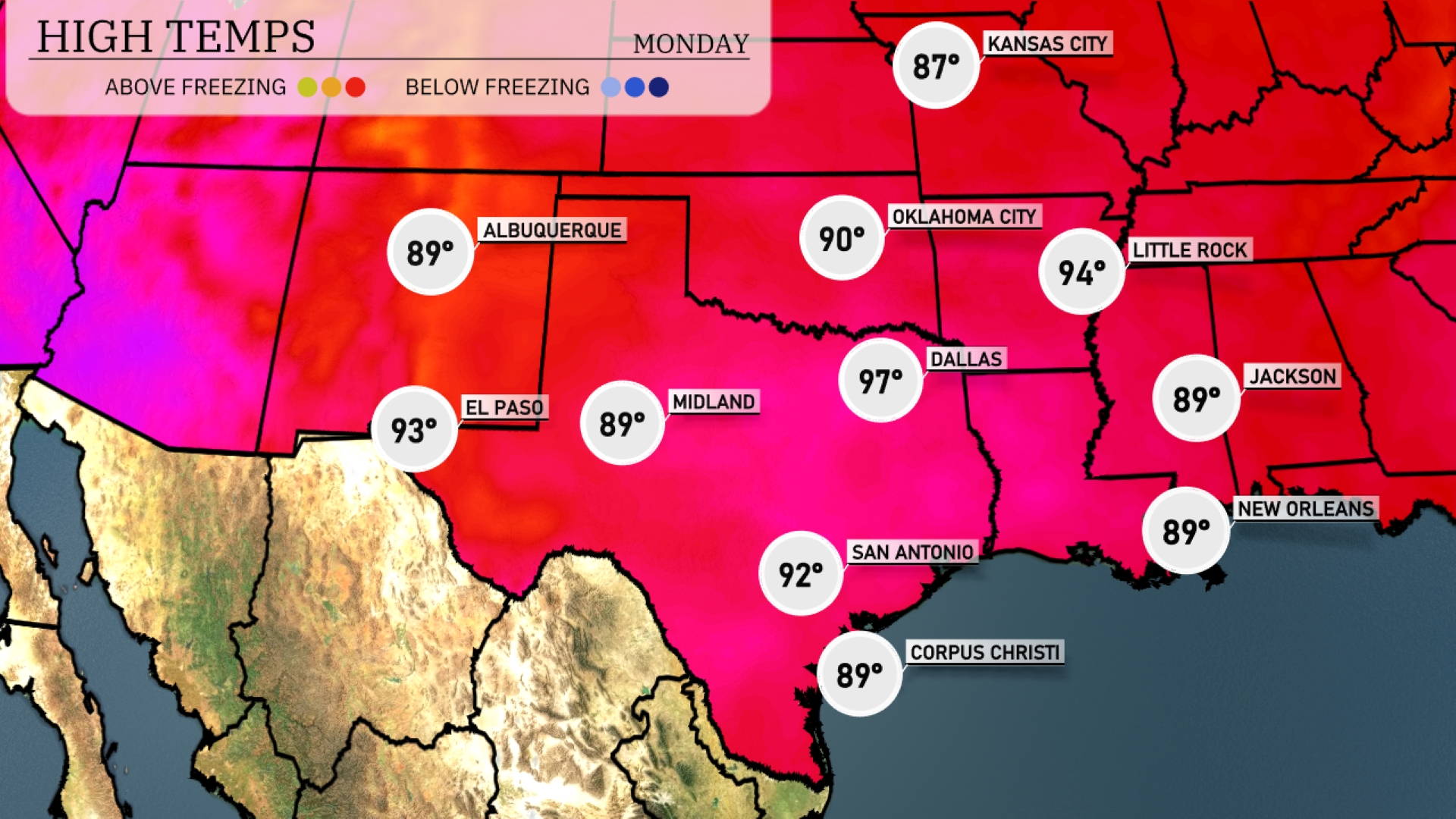
Tomorrow in the Southern Plains, Dallas will see a high of 97 degrees, well above average for this time of year. San Antonio is expected to reach 92 degrees, with Midland following closely at 89 degrees. In El Paso, temperatures will also hit 89 degrees. Little Rock is looking at a warm high of 94 degrees, while Jackson and New Orleans will be around 89 degrees. This heat wave is primarily influenced by a strong high-pressure system dominating the region, keeping conditions hot and dry.
A cold front moves through the Southern Plains tomorrow, bringing significant weather changes. Anticipate widespread rain from Dallas to Corpus Christi, offering a much-needed respite. Oklahoma City may experience stronger storms due to an unstable air mass. Be vigilant for severe weather warnings stretching southeast through Tuesday night. Behind the front, expect temperatures to drop, with drier conditions prevailing for the rest of the week.
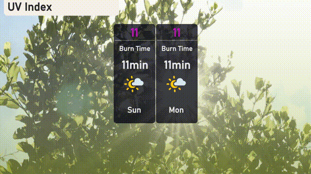
The UV index in Austin is 11 for both Sunday and Monday, reaching an extreme level with a quick burn time of about 11 minutes. It’s important to seek shade during peak hours and wear sunscreen, hats, and sunglasses to protect yourself. Stay hydrated and be mindful of any planned outdoor activities!