Austin Weather Spotlight: From Partly Cloudy to Stormy Skies
By
Amy Freeze
Explore today’s dynamic weather across Austin and the Southern Plains, from scattered showers to soaring temperatures and upcoming thunderstorms.
Today’s Austin weather brings you partly cloudy skies with a chance of scattered showers and some severe weather updates. Get all the details in our comprehensive weather report!
Welcome to your detailed weather forecast for Austin and the Southern Plains. Today, we’re seeing a variety of weather patterns from clear skies in some areas to threatening thunderstorms in others. With temperatures peaking around 90 degrees in Austin and even higher in places like El Paso, it’s a warm summer day across the region. Be informed with our full report, including a detailed 7-day forecast and safety tips for handling high UV indexes. Visit our full blog post for more insights and careful analysis. ➡️ https://amyfreeze.ai/
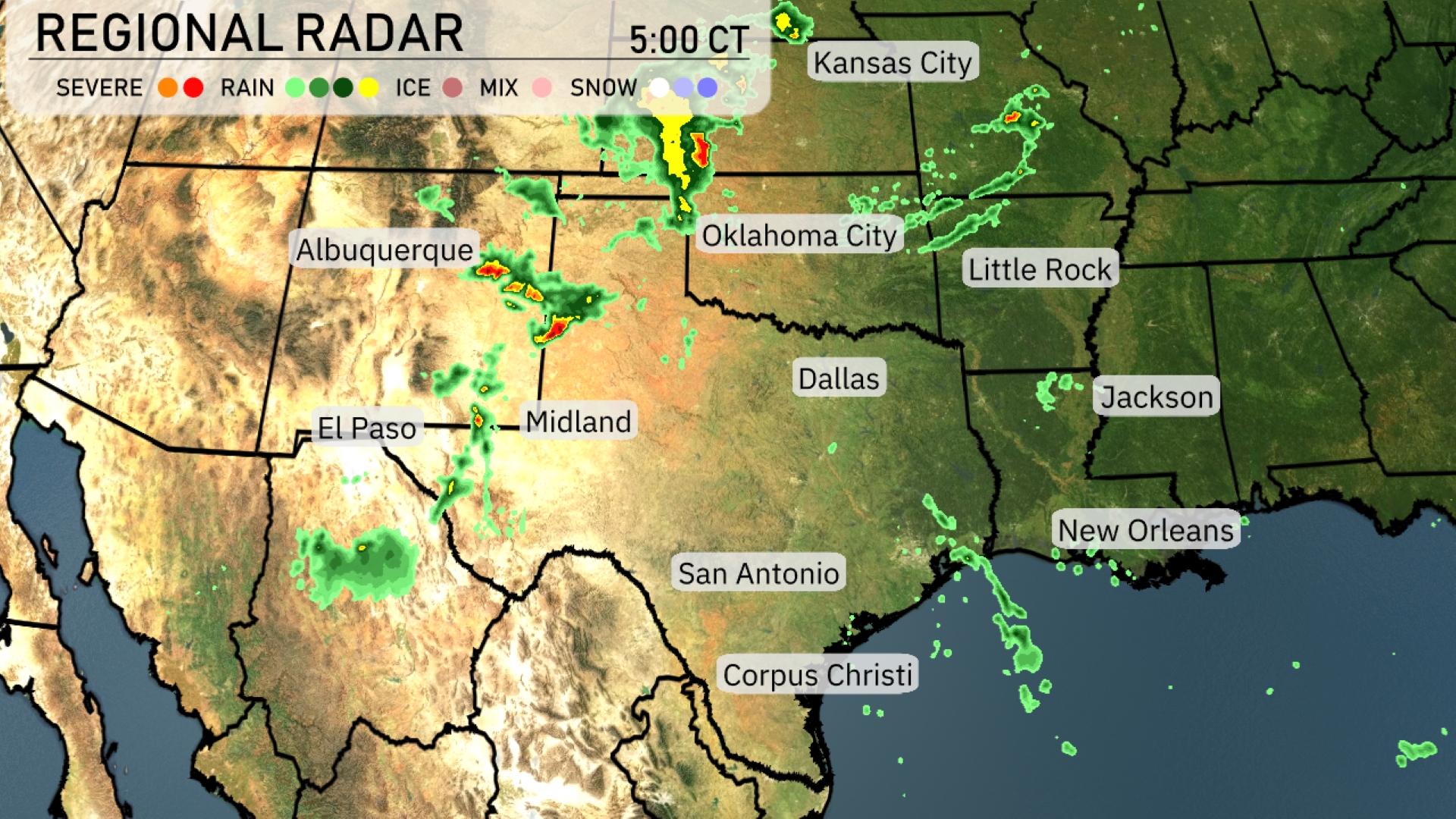
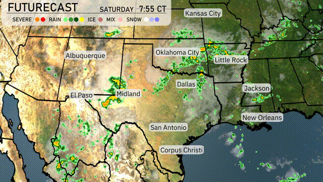
Across the Southern Plains, scattered showers are present, particularly impacting areas from Albuquerque to El Paso. Midland is catching some light rain, with similar conditions extending towards San Antonio. A strong line of storms with potential severe weather threats is moving through Northern Oklahoma, affecting areas near Oklahoma City and progressing toward Little Rock. Meanwhile, the Texas Gulf Coast, including Corpus Christi and San Antonio, is experiencing clear skies, offering a pleasant break from recent weather disturbances.
Afternoon temperatures in Austin are peaking around 90 degrees with scattered thunderstorms moving into the area. Winds will be coming from the south-southeast at 8 miles per hour. Thunderstorms are expected to continue into the early evening, with temperatures gradually lowering to 88 degrees by 6 PM. By 8 PM, clouds will dominate the skies as the temperature gently cools to 86 degrees.
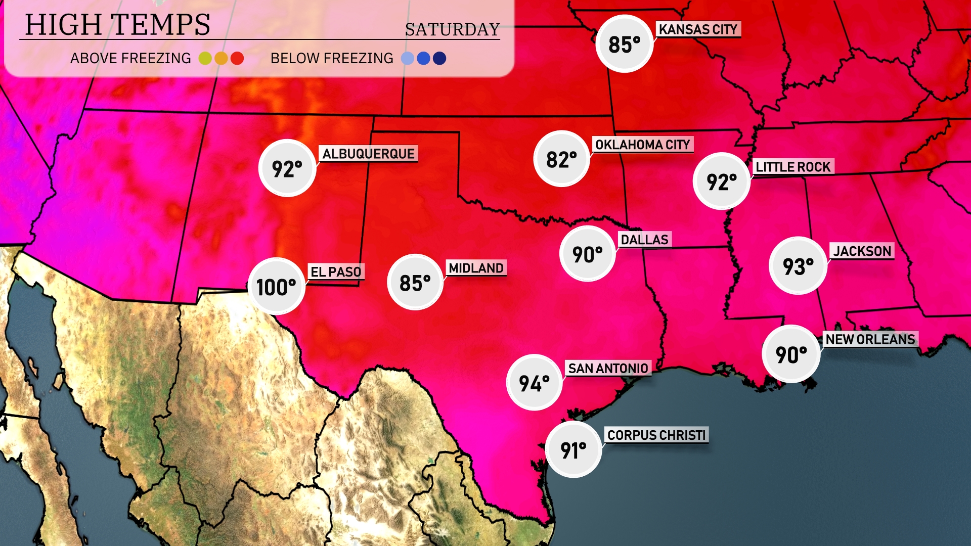
This afternoon, we’re seeing some impressive high temperatures across the Southern Plains. El Paso is sizzling at 100 degrees, while Midland checks in with a warm 85. Over in San Antonio, you can expect a high of 94, with Dallas trailing closely at 90 degrees. Heading east, New Orleans warms up to 90 degrees, and Jackson will reach a steamy 93. Meanwhile, Little Rock enjoys a toasty 92 degrees, showcasing the consistent summer heat throughout the region.
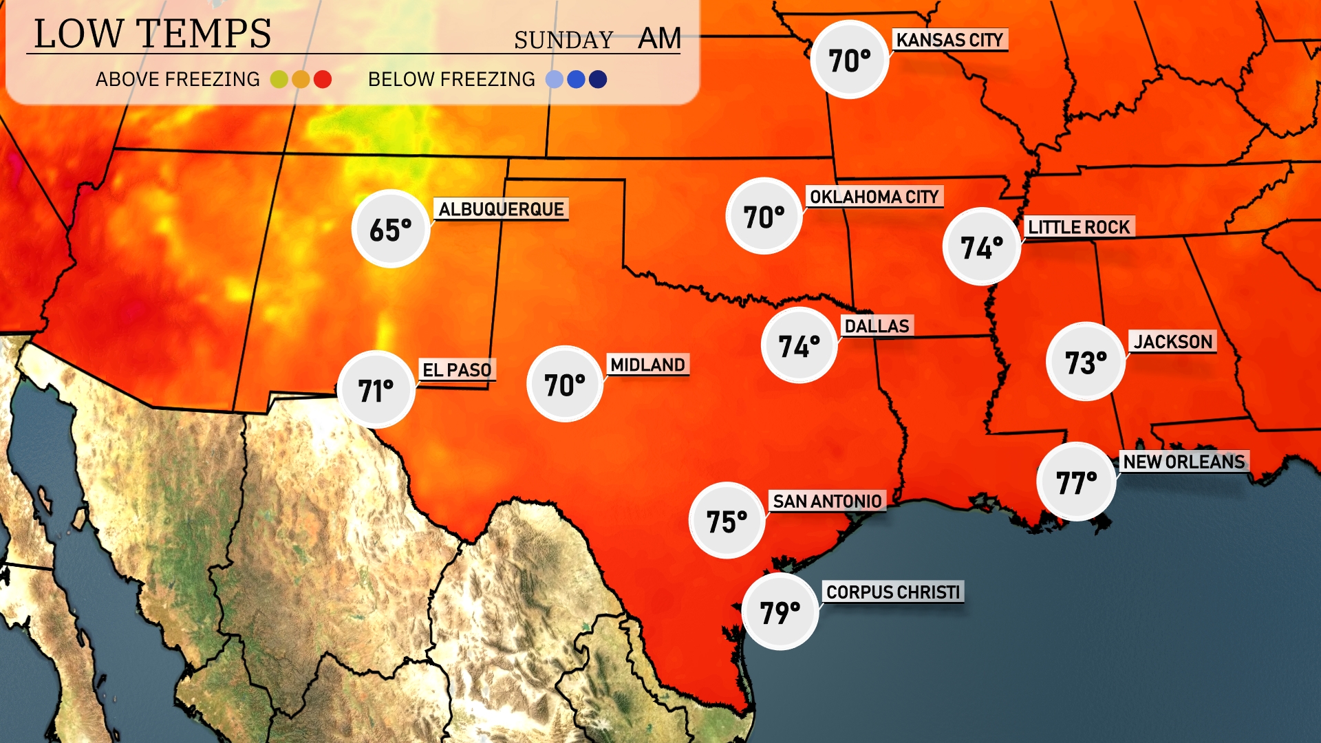
Tonight, Dallas will see a low of 74 degrees, while Little Rock drops to 74 as well. San Antonio is forecasted to be slightly warmer at 75 degrees. Expect 77 degrees in New Orleans, and Corpus Christi remains the warmest at 79. Overall, mild temperatures will prevail across the Southern Plains tonight.
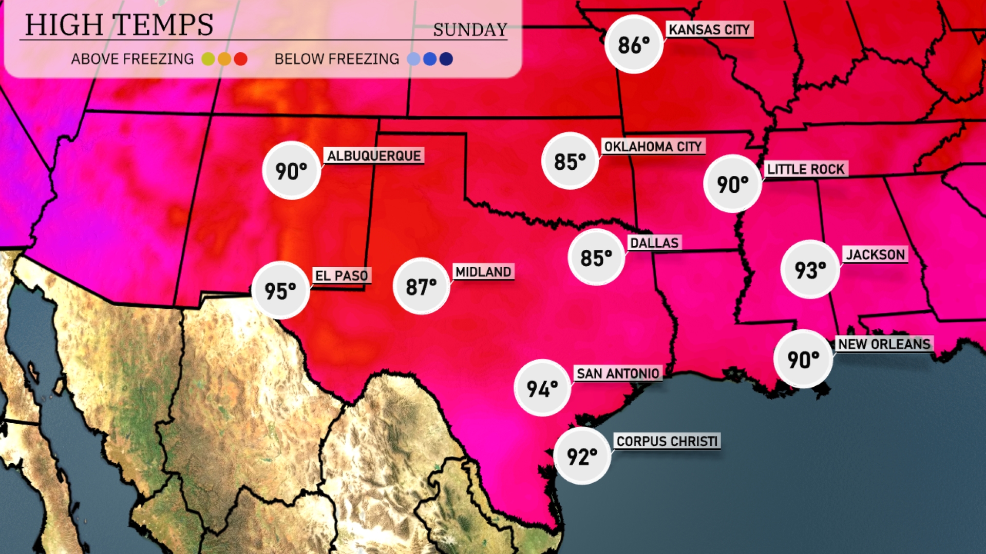
Tomorrow in El Paso, expect a warm high of 95 degrees. Midland will reach 87, while Dallas sees a high of 85 degrees. In San Antonio, temperatures will climb to 94, and Corpus Christi will be slightly cooler at 92. Jackson and Little Rock will also experience summer-like conditions, with highs around 93 and 90 degrees, respectively. Overall, temperatures are well above average for this time of year across the Southern Plains, influenced by persistent high-pressure systems.
A robust cold front is moving into the Southern Plains, with thunderstorms developing across central Texas and Oklahoma. Expect periods of heavy rain from Dallas to Oklahoma City, potentially leading to some localized flooding. The thunderstorms may bring gusty winds and lightning. By mid-day tomorrow, this system will track eastward, bringing showers into Arkansas and Louisiana. Temperatures are expected to drop following the frontal passage.
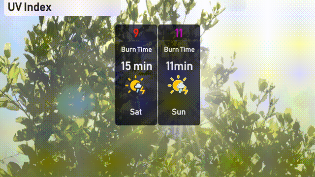
The UV index in Austin today, Saturday, is very high at 9, with a burn time of just 15 minutes under the sun. On Sunday, it climbs even higher to 11, reducing the burn time to 11 minutes! Be sure to apply sunscreen generously and seek shade during peak UV hours for both days.