Austin Ascends: Sunny Spree to Stormy Siege – Your Weekly Weather Digest
By
Amy Freeze
Explore the oscillating weather patterns over Austin and the Southern Plains, from balmy sunsets to storm alerts. This week brings a mix of clear skies and severe weather threats.
This week in Austin, expect anything from sunny skies to severe storms. Click to read more about the day-by-day forecasts and safety tips!
Welcome to this week’s comprehensive weather overview for Austin and the Southern Plains. Starting with sun-drenched skies and wrapping up with storm warnings, each day brings new conditions to prepare for. We analyze temperature fluctuations, storm probabilities, and safety precautions you need to know. Full details on our blog!
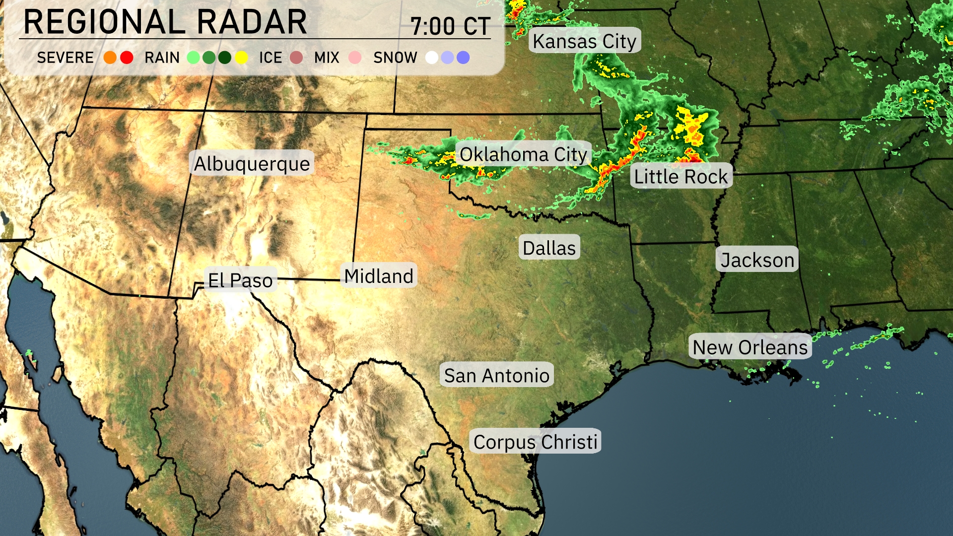
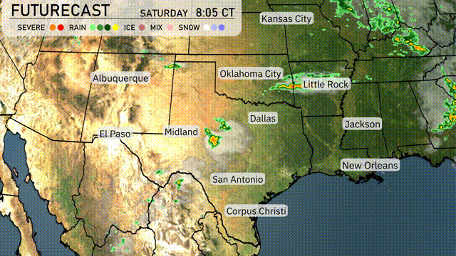
Across the Southern Plains, the regional radar highlights active weather in the northeastern parts. Thunderstorms are developing just north of Oklahoma City, extending towards Little Rock, bringing intense precipitation. Kansas City is on the brink of experiencing significant rainfall as the storm progresses. The skies are clearer over the southern areas, including Dallas and San Antonio, where conditions are currently dry.
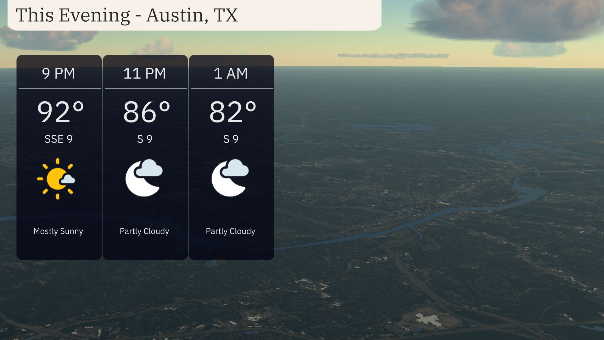
For this evening in Austin, the weather begins mostly sunny at 9 PM with a temperature of 92 degrees and a southeast wind at 9 mph. By 11 PM, the sky turns partly cloudy as temperatures dip to 86 degrees with winds remaining southerly at 9 mph. At 1 AM, expect it to be partly cloudy with a temperature of 82 degrees and consistent south winds at 9 mph.
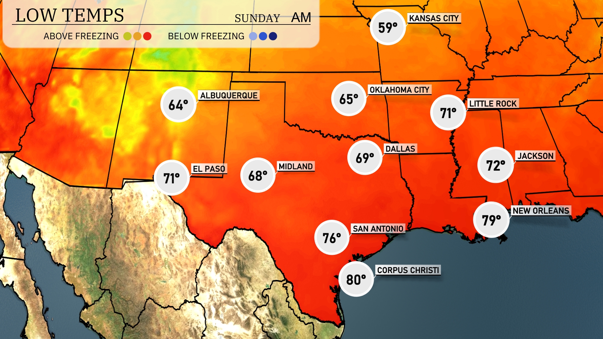
Tonight in Dallas, expect a low of 69 degrees. Oklahoma City will dip to 65, while Little Rock will see a low of 71. In Midland, temperatures will fall to 68 degrees, and El Paso is forecasted at 71. The southern region maintains warmer conditions, with San Antonio at 76 and Corpus Christi at a mild 80 degrees.
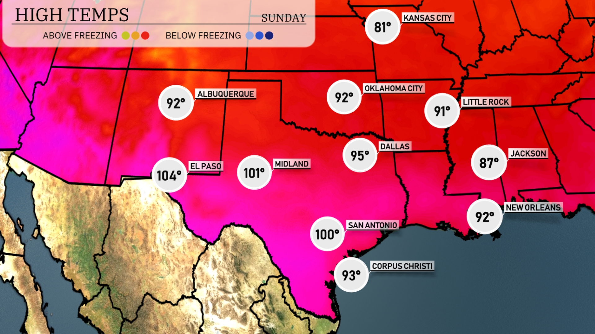
Tomorrow in the Southern Plains, we’ll see some toasty temperatures. El Paso will soar to a scorching 104 degrees, while Midland hits 101 degrees, both well above average for this time of year. San Antonio is expected to reach 100 degrees, and Dallas will be hot as well with a high of 95. Over in New Orleans, expect a warm day at 92 degrees, while Jackson will be slightly cooler at 87.
A cold front slicing through the Southern Plains brings showers and thunderstorms tomorrow. From Dallas to Oklahoma City, expect potential severe storms, including heavy downpours and gusty winds—be ready for severe weather alerts. As the system progresses into Arkansas and Louisiana by late afternoon, rainfall could be intense, with the possibility of flash flooding. Temperatures will dip slightly once the front clears, offering cooler and drier conditions into the weekend.
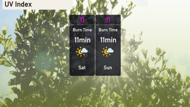
Expect a very high UV index of 11 in Austin this Saturday and Sunday, with significant sun exposure risks. The burn time is a short 11 minutes, so it’s important to frequently apply sunscreen and wear protective clothing.
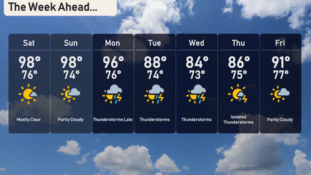
For the 7-day forecast in Austin:
Saturday: Mostly clear skies with a high of 98 degrees and a low around 76 degrees.
Sunday: Partly cloudy throughout the day, high reaches 98 degrees, and the low will be 74 degrees.
Monday: Thunderstorms are expected later in the day, with temperatures peaking at 96 degrees and dipping to 76 degrees overnight.
Tuesday: Anticipate more thunderstorms with a high of 88 degrees and a low of 74 degrees.
Wednesday: More thunderstorms in the forecast, with daytime temperatures hitting 84 degrees and dropping to 73 degrees by night.
Thursday: Isolated thunderstorms are possible, the high will be around 86 degrees with a low of 75 degrees.
Friday: The week wraps up with partly cloudy skies and temperatures rising to 91 degrees, cooling down to 77 degrees at night.