Chicago Weather This Evening: From Cloudy Skies to Storm Alerts
By
Amy Freeze
Dive into tonight's weather nuances as the Midwest prepares for an eventful evening. From Chicago’s cloudy skyline to emerging storms in the region, get all the details right here!
Find out what’s up with Chicago’s weather tonight and how the Midwest is bracing for more storms. Catch all you need to know about the impending weather changes in your area!
Weather enthusiasts and Chicagoans! Our latest blog post covers this evening’s weather dynamics from cloudy skies to the thunderstorms tracking through the Midwest. We take you through each hour’s forecast in Chicago and outline the expected storm paths and impacts across different cities, including temperature variances and storm strengths. Plus, a peek at the UV index warnings. Comprehensive, precise, and designed to keep you informed.
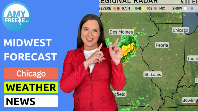
The Midwest regional radar shows a line of storms moving through central Missouri, advancing towards Illinois, with St. Louis currently facing thunderstorm activity. Peoria and Springfield are anticipating the arrival of this weather system as it progresses eastward. Light rain showers extend from Kansas City up to Des Moines, creating wet conditions without severe intensification. Areas like Detroit and Cleveland are under cloud cover but remain dry, providing a brief respite from precipitation.
For this evening in Chicago, expect cloudy skies with temperatures gradually cooling from 79 degrees at 9 PM to 74 degrees by 1 AM. Winds will be from the southwest, decreasing slightly into the night, with speeds around 7 miles per hour earlier on, then 4 miles per hour. The cloud cover will persist throughout the evening, maintaining a calm and stable weather pattern.
Tonight, Chicago will see a low of 67 degrees, while Indianapolis cools down to 69. Cleveland is expecting a low of 71, with Peoria slightly cooler at 66. St. Louis is forecasted to drop to 71, maintaining mild temperatures across the Midwest.
Tomorrow, Kansas City will soar to a sizzling 92 degrees, while St. Louis will reach 90 degrees. Expect Peoria and Des Moines to hit the upper 80s, at 89 degrees each. Indianapolis will have a warm afternoon with a high of 87 degrees, and Louisville will follow closely at 88 degrees.
A warm front will lift through the Midwest tomorrow, bringing scattered thunderstorms from Kansas City to Chicago by late afternoon. Expect localized heavy rainfall and strong wind gusts, primarily impacting the Indiana and Ohio area. Temperatures will hold steady in the mid-80s across the region, peaking as the front stabilizes by late evening. Louisville and Indianapolis should prepare for potential flash flood advisories due to saturated grounds. By Wednesday morning, the storm system will taper off, leading to clearer skies and a drop in humidity.
The UV index in Chicago will be very high on Tuesday at 8, with a burn time of 17 minutes, suggesting limited sun exposure and protective measures like sunscreen are essential. On Wednesday, the UV index increases to 9, with a burn time of just 15 minutes.
Tuesday: Cloudy skies with a high reaching up to 88 degrees and a low of 70 degrees.
Wednesday: Partly cloudy conditions anticipated with temperatures peaking at 83 degrees and falling to 67 degrees.
Thursday: A similar partly cloudy day with the thermometer hitting 81 degrees while dipping to 69 degrees.
Friday: Be prepared for scattered thunderstorms with highs of 88 degrees and lows around 73 degrees.
Saturday: Expect partly cloudy weather, with temperatures at a high of 86 degrees and a nighttime low of 68 degrees.
Sunday: Mostly clear conditions, the high will reach 88 degrees with an overnight low of 69 degrees.
Monday: Warming trend continues with partly cloudy skies, touching a high of 91 degrees and a low of 73 degrees.