Chicago’s Midweek Meteorology: A Symphony of Skies and Storms
By
Amy Freeze
Explore the varying conditions from sunny spells to stormy evenings across Chicago and the broader Midwest. Stay updated and prepared with our thorough weather analysis.
This week in weather brings a blend of sun, clouds, and storms to Chicago and the Midwest. Dive into our forecasts for daily insights and stay prepared!
As we navigate through another week in the Midwest, weather patterns continue to surprise us. Chicago enjoys brief sunny intervals amid cloudy skies, while a cold front threatens with storms and potential severe weather. With fluctuating temperatures and sporadic downpours, our comprehensive forecast helps you plan effectively, whether it’s a workday commute or weekend outing. Detailed temperature ranges, storm warnings, and UV index insights are covered in our extensive blog post.
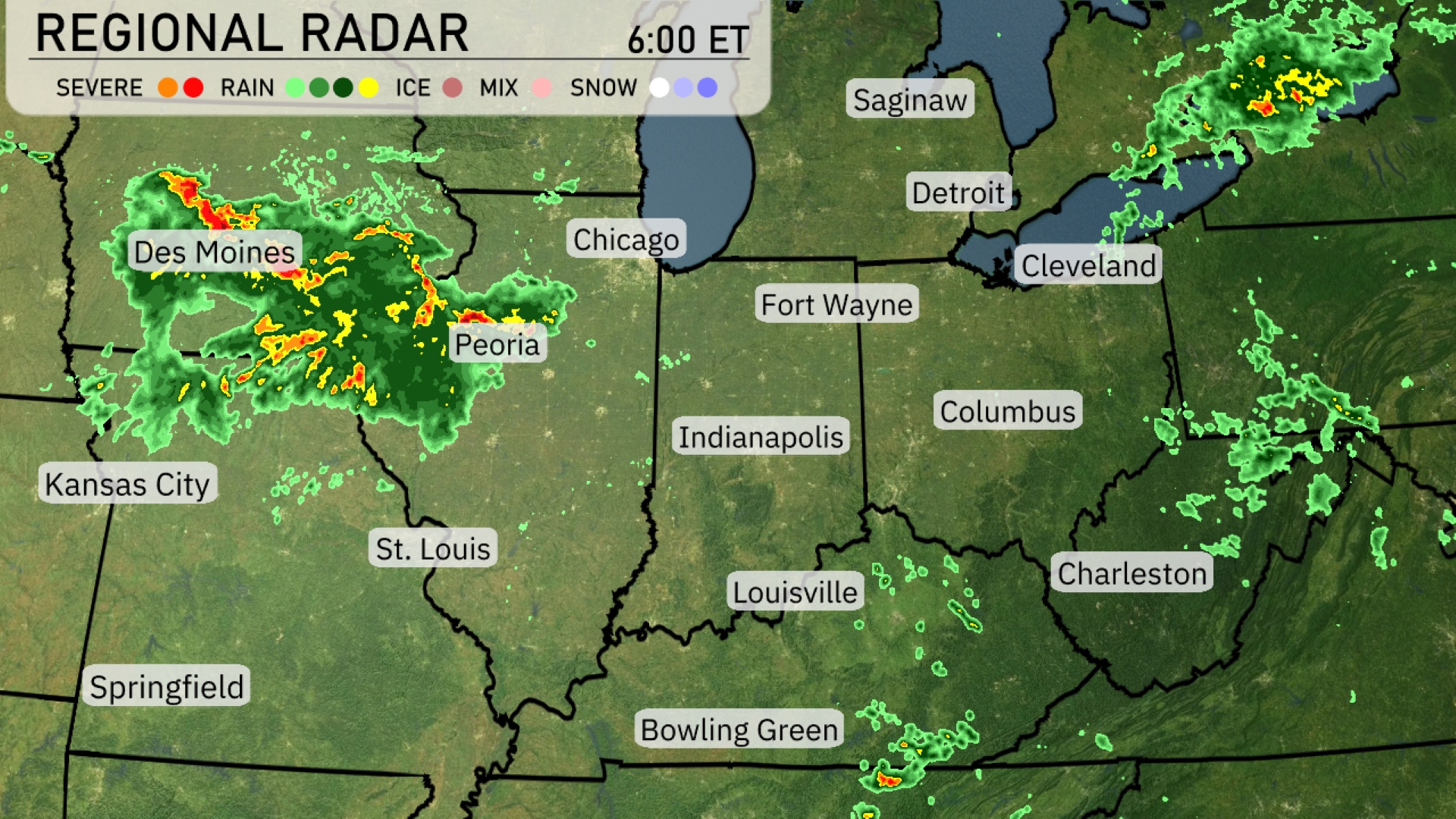
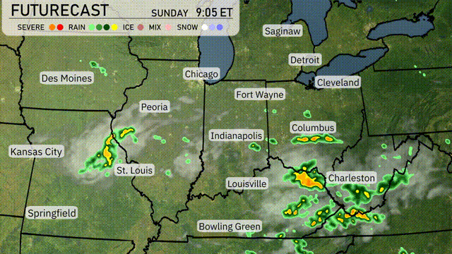
Across the Midwest, the regional radar shows a strong line of storms stretching from Des Moines to Peoria, delivering heavy rain and potential severe weather. Cloud cover and rain are spreading towards Chicago, where showers are expected to continue. Meanwhile, lighter showers are moving through Indianapolis, with the potential for rain increasing as the day progresses. Clear conditions prevail over Springfield and much of southern Illinois, providing a temporary respite from the storm activity further north.
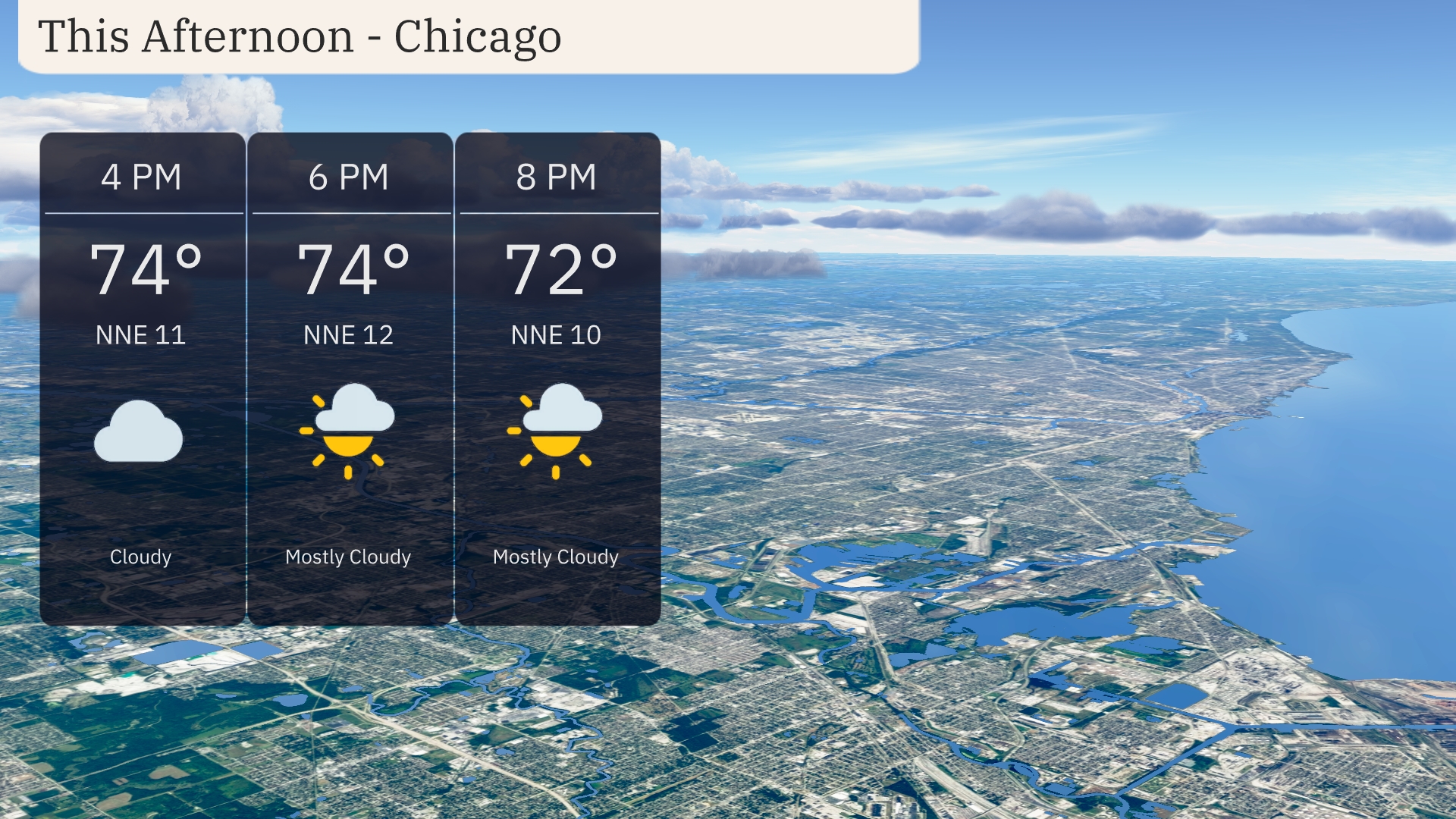
In Chicago this afternoon, temperatures hold steady at 74 degrees with a shift to mostly cloudy skies by 6 PM. Winds from the north-northeast at 12 mph provide a cool breeze. By 8 PM, temperatures slightly dip to 72 degrees while the cloud cover begins to break, offering partly sunny skies.
In the Midwest today, we’re seeing a range of high temperatures. Chicago is likely to reach a pleasant 76 degrees, while Peoria will warm up to 81. Heading south, St. Louis is hotter with a high of 94, and Kansas City sizzles at 93. Meanwhile, Indianapolis has a comfortable high of 84 degrees, while Louisville will see temperatures climb to 91. A warm air mass is prominent across the region, contributing to these summer-like conditions.
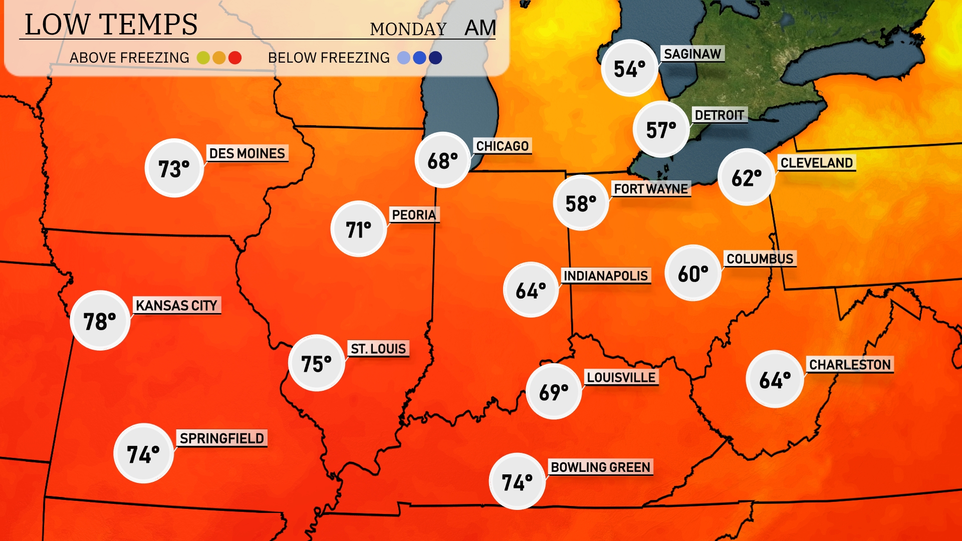
Tonight, temperatures in the Midwest will vary significantly, with Des Moines dropping to 73 degrees and Kansas City cooling down to 78. Chicago will experience a low of 68 degrees, while Fort Wayne and Indianapolis will see cooler temperatures at 58 and 64 degrees, respectively. Look out for a chilly night in Detroit, where the mercury will fall to 57 degrees and further north in Saginaw, it’s expected to reach a low of 54 degrees.
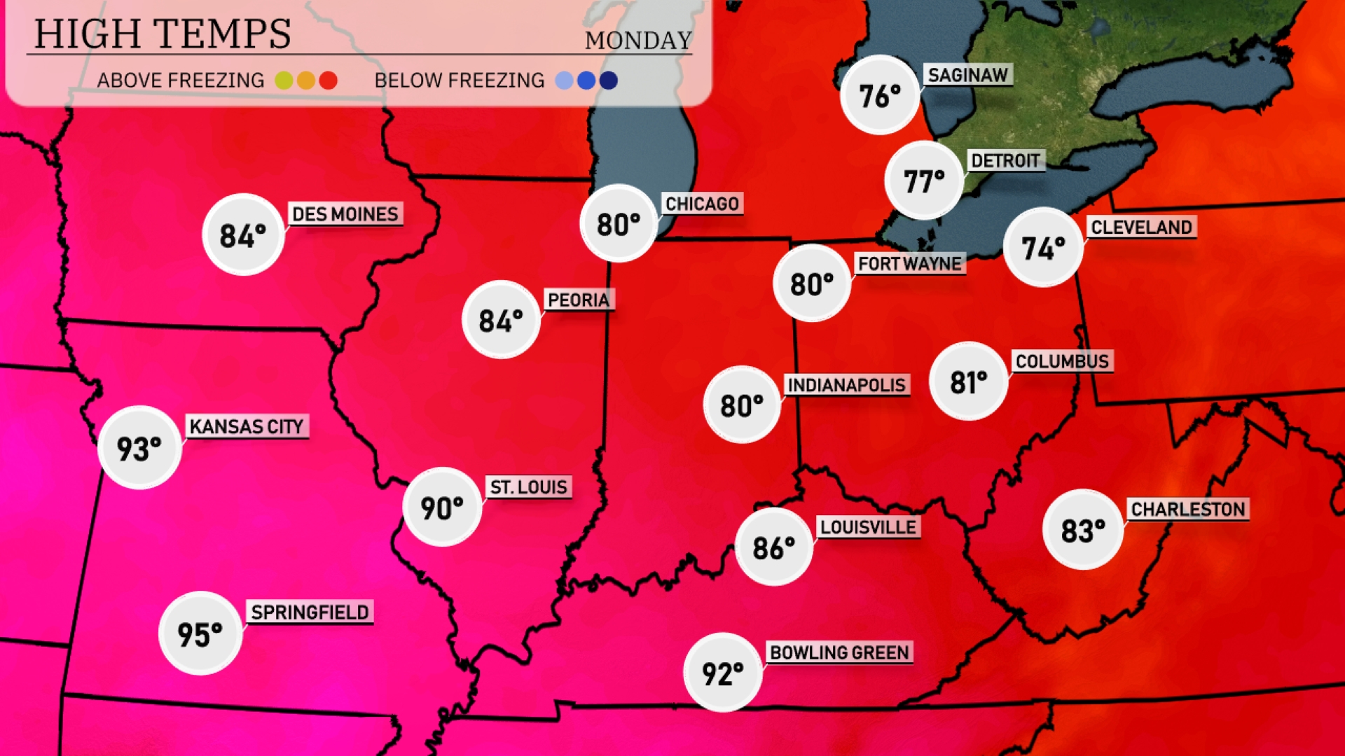
Tomorrow in the Midwest, expect a warm day with highs significantly above average. Kansas City will hit a scorching 93 degrees, while St. Louis reaches 90. Indianapolis and Fort Wayne are both set to see highs of 80 degrees. Bowling Green will come in slightly warmer at 92 degrees, and Louisville isn’t far behind at 86. Cooler temperatures can be anticipated in Cleveland, where highs will only reach 74 degrees.
In the Midwest, a passing cold front will bring showers and thunderstorms to St. Louis and Kansas City this afternoon, moving towards Chicago later in the evening. Minor flooding could result from heavy rain, especially in low-lying areas. Expect temperatures to dip slightly post-front, providing a cooler respite with highs in the mid-70s°F across the region tomorrow. Keep an eye on potential severe storms, primarily in areas near Indianapolis and Peoria, with gusty winds and hail possible. By late Monday, conditions will gradually clear, making way for sunny breaks and drier weather as we head into Tuesday.
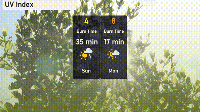
Today’s UV index in Chicago is moderate at 4, with a potential burn time of about 35 minutes when exposed to sunlight. Tomorrow, expect the UV index to jump to 8, which is high, cutting the burn time down to just 17 minutes. Remember, applying sunscreen and using protective measures is key, especially with tomorrow’s stronger sun exposure!