Navigating Chicago’s Changing Skies: Your Complete Weather Forecast
By
Amy Freeze
Dive into the comprehensive weather forecast with Amy Freeze as we break down the mild mornings, potential thunderstorms, and all the crucial updates for a week of varied temperatures in Chicago and across the Midwest.
Explore the latest weather trends in Chicago with expert Meteorologist Amy Freeze. From morning calm to stormy afternoons, get your complete, detailed forecast here!
Join Amy Freeze as she navigates through the weather dynamics of Chicago and the wider Midwest region. This detailed forecast includes everything from mild morning temperatures to potential thunderstorms, highlighting how the weather could impact your daily activities. With professional insights and updates on temperature changes and storm alerts, this is your go-to resource for planning ahead. Don’t miss out on the weekly forecast, specially tailored for residents and visitors of the Chicago area, ensuring everyone stays safe and informed.
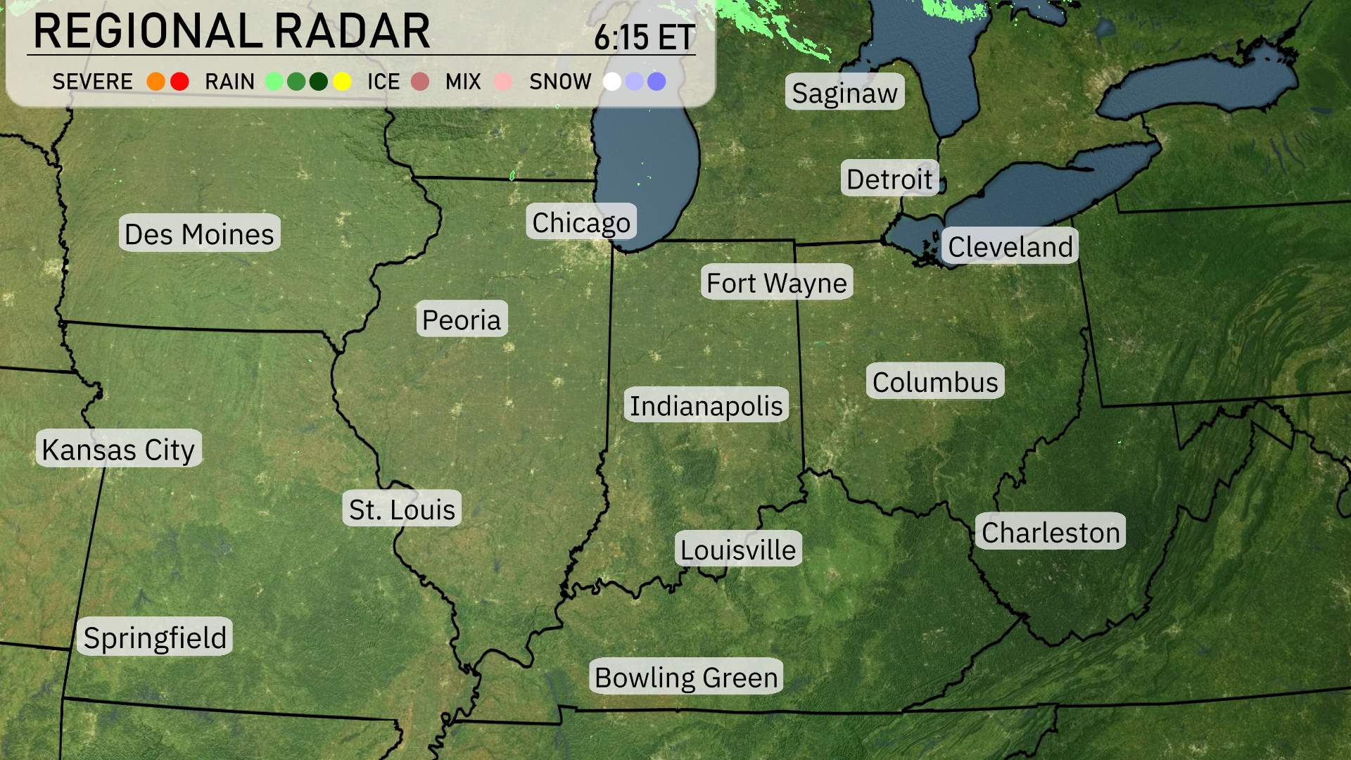
The Midwest is currently experiencing calm and clear conditions on the radar. From Chicago to St. Louis, skies are predominantly clear, providing a pleasant day across the region. A noticeable patch of rain is sweeping across northern Michigan, affecting areas like Saginaw. Cleveland is witnessing a mix of rain and cloudy skies moving in from the northwest, as this system pushes southeast. Fort Wayne and Indianapolis are enjoying clear skies, while Detroit is on the edge of the incoming precipitation band. Farther south, locations such as Louisville and Bowling Green are basking in sunny weather, making it a great day to be outside.
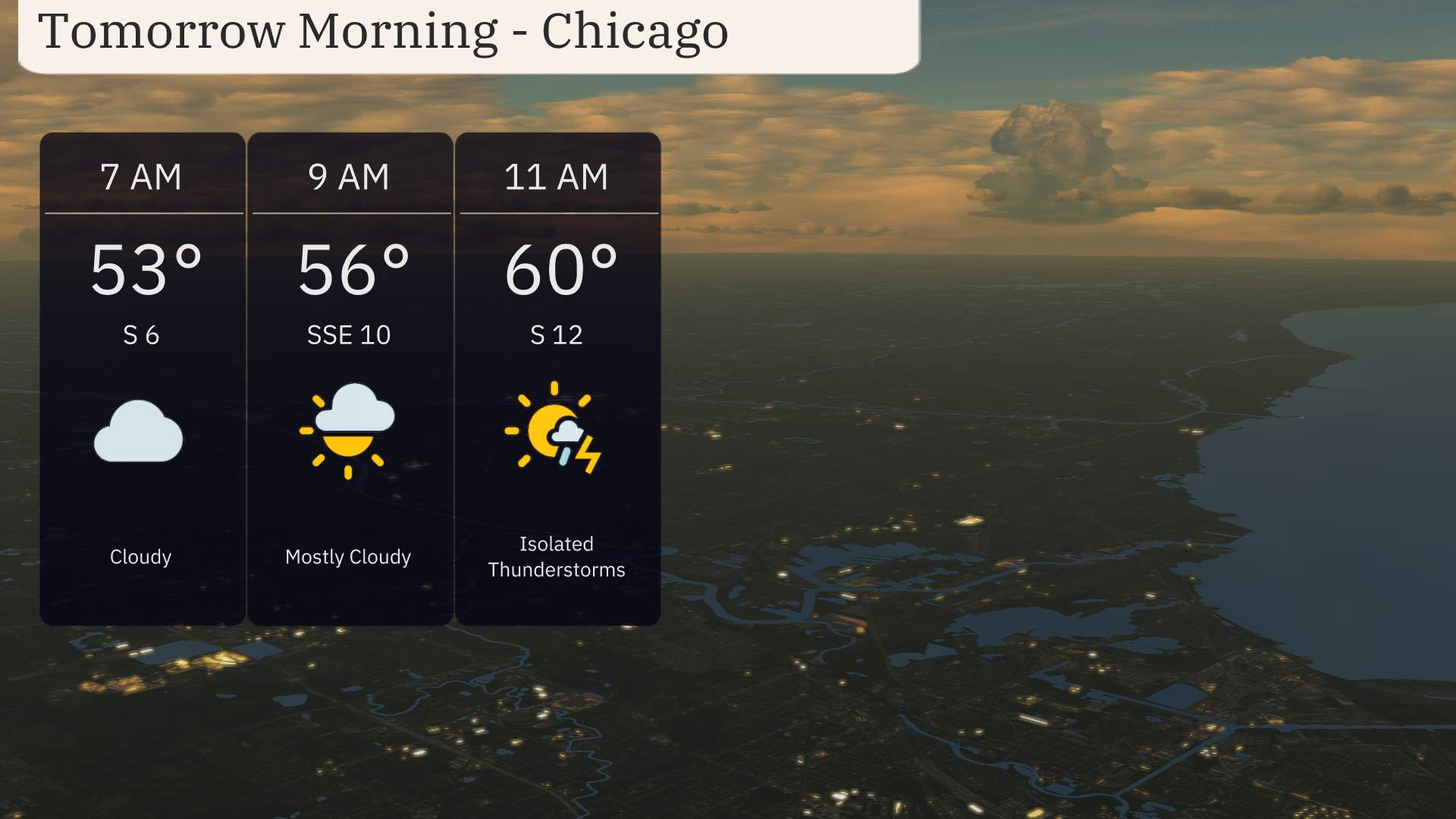
Tomorrow morning in Chicago will begin with temperatures around 53 degrees at 7 AM, under cloudy skies with a south wind at 6 miles per hour. As we move into 9 AM, expect mostly cloudy conditions with temperatures rising to 56 degrees and a south-southeast wind at 10 miles per hour. By 11 AM, isolated thunderstorms are possible as temperatures reach 60 degrees with a south wind at 12 miles per hour. Stay weather-aware and have your umbrella handy if you’re stepping out.
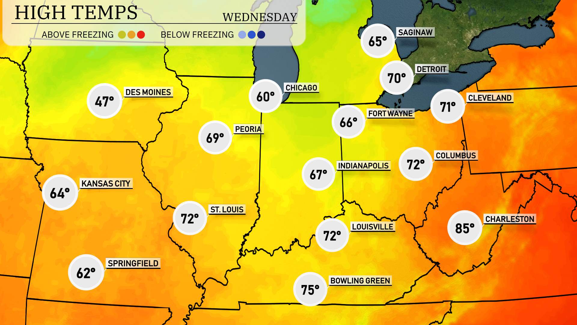
High temperatures for Wednesday in the Midwest are leaning towards mild and pleasant conditions.
In St. Louis, expect a high of 72 degrees, while Kansas City will be slightly cooler at 64 degrees. Chicago enjoys a nice 60 degrees, and Peoria is looking at a high around 69 degrees. Farther to the southeast, Indianapolis is forecasted for 67 degrees, with Louisville reaching 72 degrees.
Notably, Bowling Green is set to warm up to 75 degrees, and Charleston, West Virginia, is forecasted for a significant high of 85 degrees—well above the average for this time of year. Weather patterns moving through the region are contributing to these warming trends, leading to a fairly pleasant day overall.
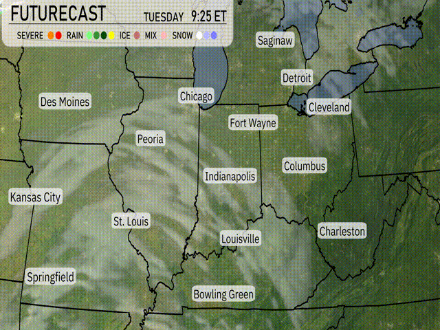
“A line of rain showers stretches from Des Moines to Springfield, moving eastward overnight into Indiana. On Tuesday, expect gusty winds and scattered showers primarily over Chicago and stretching down to Indianapolis. By afternoon, a potent cold front begins to push through, bringing heavier precipitation and possible thunderstorms around Fort Wayne and Cleveland. Temperatures will cool down significantly as the front progresses eastward over the next 48 hours. Stay informed, especially if traveling, as conditions might become slippery.”
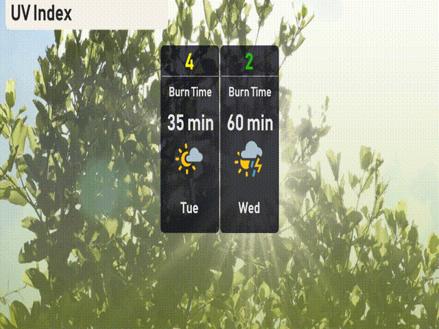
The UV index in Chicago will be moderate on Tuesday with a level of 4, indicating a burn time of about 35 minutes in direct sunlight. By Wednesday, cloud cover and potential storms will lower the UV index to 2, reducing sun exposure concerns significantly.
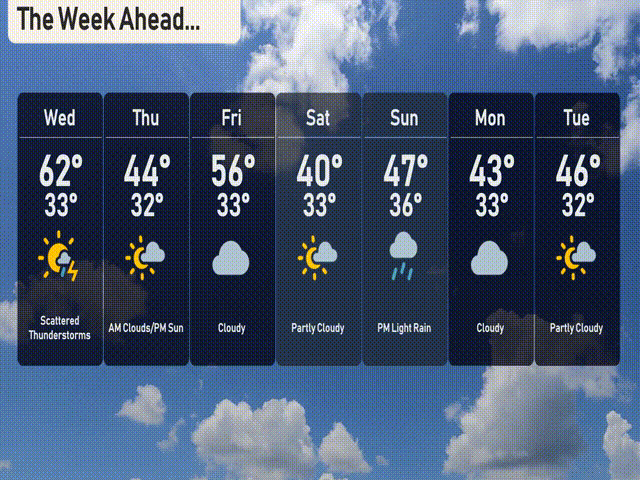
For the 7-day forecast in Chicago:
Wednesday: Scattered thunderstorms with a high of 62 degrees and a low of 33.
Thursday: Morning clouds clearing by afternoon, cooling down to a high of 44 degrees and a low of 32.
Friday: Cloudy skies with temperatures reaching a high of 56 degrees and a low near 33.
Saturday: Sunshine peeking through with partly cloudy conditions, a high of 40 degrees and a low of 33.
Sunday: Expect evening light rain with a high of 47 degrees and a low around 36.
Monday: Cloudy with a high of 43 degrees, and temperatures dropping to 33 at night.
Tuesday: Partly cloudy with daytime highs of 46 degrees and nighttime lows of 32.