Meteorologist Amy Freeze guides you through the serene Chicago evening and prepares you for the upcoming stormy weather in the Midwest. Stay informed and safe with detailed forecasts and weather tips.
Explore a calm evening in Chicago before the storm hits the Midwest! Meteorologist Amy Freeze provides essential updates for the upcoming week. Stay ahead of the weather.
Meteorologist Amy Freeze here from Chicago with your Midwest Forecast update. Severe storms are brewing across the region while Chicago enjoys a peaceful evening. We cover everything from temperature dips, gusty winds, and storm forecasts, ensuring you’re prepared for any weather event. Check daily for more updates and useful tips to handle unexpected weather changes.
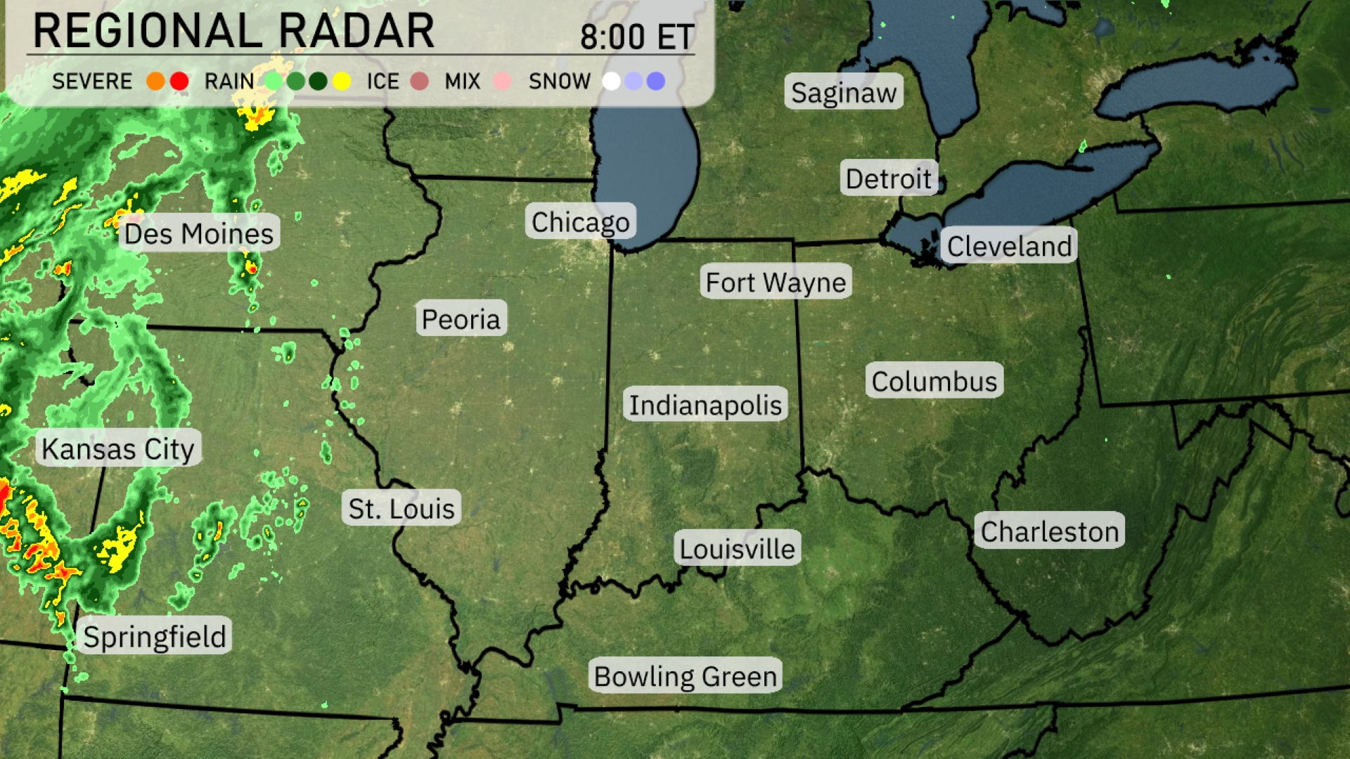
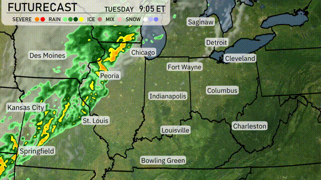
Stormy weather is unfolding in the Midwest, with a line of severe storms advancing from Kansas City towards Des Moines. Rain and thunder are spreading into Springfield, bringing gusty winds and downpours. Fort Wayne and Indianapolis are seeing increasing cloud cover as the system moves eastward. Chicago remains just north of the action, experiencing cloudy skies without precipitation. Conditions are calm in Columbus and Cleveland, offering a brief reprieve from the approaching weather system.
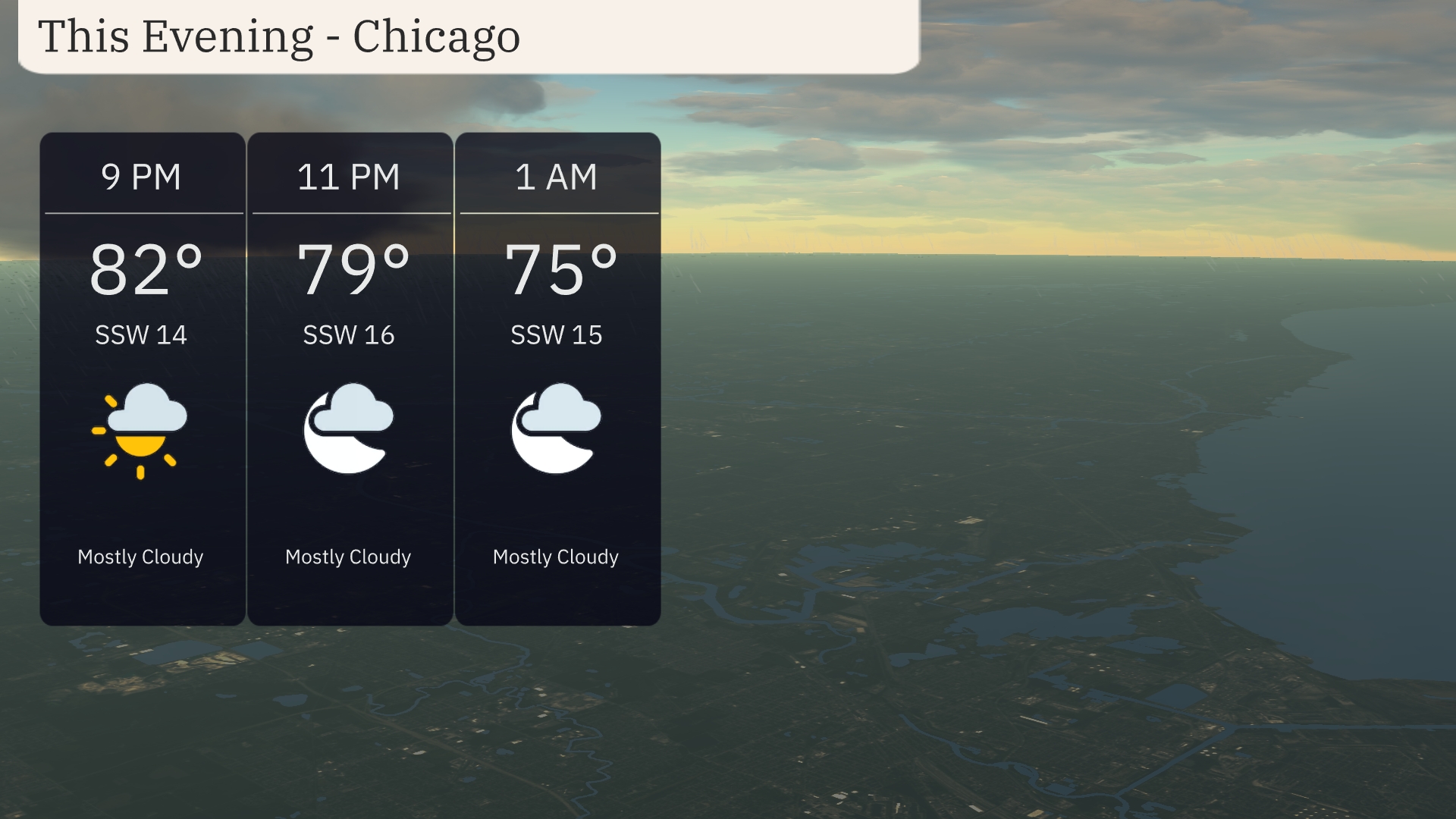
For this evening in Chicago, temperatures will be in the low 80s at 9 PM, gradually cooling down to 79 degrees by 11 PM and reaching 75 degrees at 1 AM. Expect mostly cloudy skies throughout the evening. Winds will be coming from the south-southwest with speeds ranging from 14 to 16 miles per hour, providing a gentle but consistent breeze.
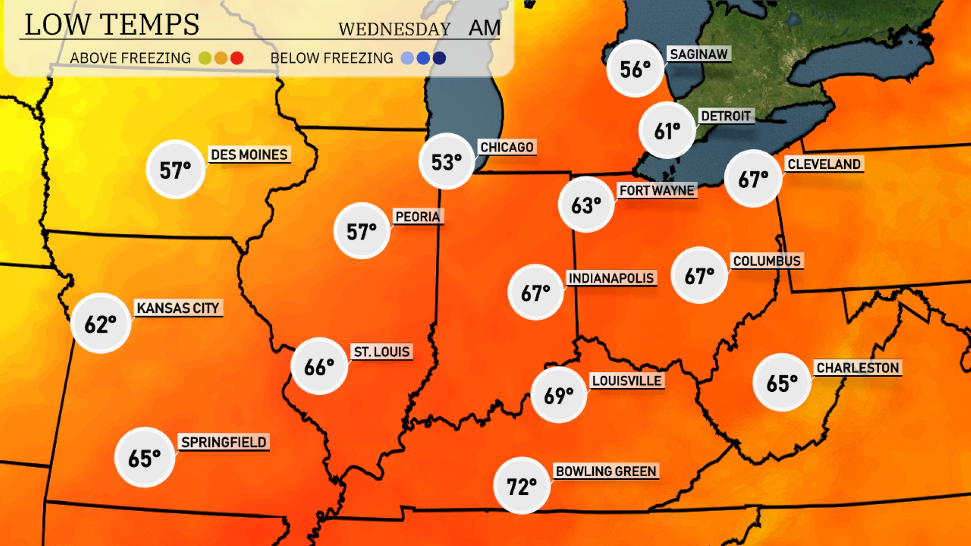
Tonight Chicago will cool down to 53 degrees, while Peoria drops to 57. Indianapolis is set for a low of 67, with Louisville not far behind at 69. St. Louis will remain relatively mild at 66 degrees. Expect a cooler night with lows around 62 in Kansas City.
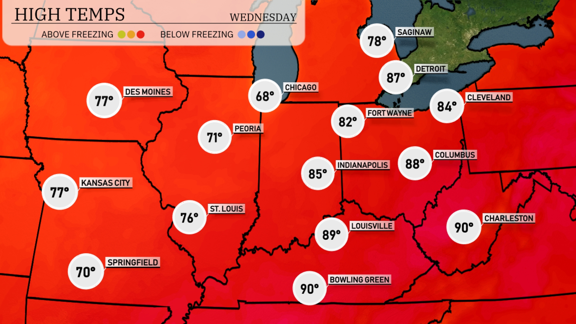
Tomorrow Indianapolis is projected to reach 85 degrees, while Louisville could see an even warmer 89 degrees. Bowling Green and Charleston approach the 90-degree mark, indicating a hot day ahead. Chicago will be relatively cooler at 68 degrees, but still higher than season norms.
Rain develops in the Midwest, moving east from Kansas City towards Chicago and Detroit. Heavy showers with occasional thunderstorms could cause brief flooding in low-lying areas. Plan for gusty winds and possible hail, particularly in the afternoon. As the rain system shifts eastward, temperatures will drop slightly, providing a cool and windy day on Wednesday.
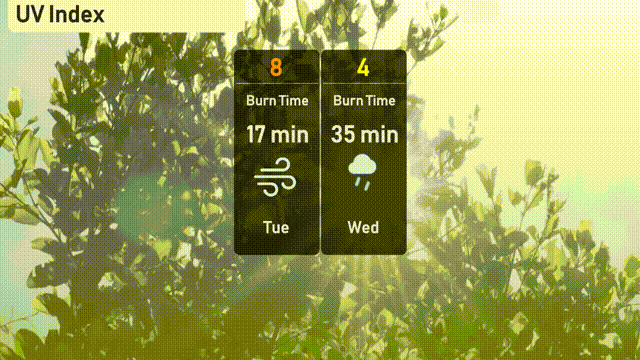
The UV index in Chicago on Tuesday will reach a high of 8, with a burn time of just 17 minutes, so be sure to wear sunscreen and protective clothing. However, by Wednesday, cloud cover will significantly reduce UV exposure, dropping the index to a more moderate 4 with a longer burn time of 35 minutes.
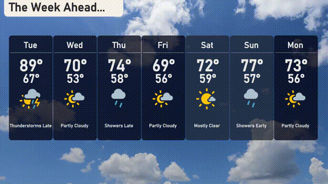
Tuesday: Thunderstorms late in the day with a high of 89 degrees and a low of 67.
Wednesday: Partly cloudy skies and a cooler high of 70 degrees, dropping to 53 at night.
Thursday: Showers move in late with a high of 74 degrees and a low of 58.
Friday: Expect partly cloudy conditions, a high reaching 69 degrees, and a nighttime low of 56.
Saturday: Mostly clear with temperatures warming to 72 degrees during the day, cooling to 59 at night.
Sunday: Showers expected early with a high of 77 degrees and a low around 57.
Monday: Look for partly cloudy skies with temperatures peaking at 73 degrees and dipping to 56 overnight.