Chicago and the Midwest: A Forecast of Sun, Storms, and Surprises
By
Amy Freeze
Stay ahead of the weather with our detailed forecast for Chicago and the Midwest region. From sunny days to stormy nights, know what's coming!
Predicting the Unpredictable: Catch Your Chicago & Midwest Weather Update!
This weekend in the Midwest heralds a blend of clear skies and storm warnings. Whether you’re in Chicago or across Missouri, here’s everything you need to know about the upcoming weather fluctuations. We’ve got info on the UV index, late-night temperature dips, and much more. For a detailed analysis, read our full article.
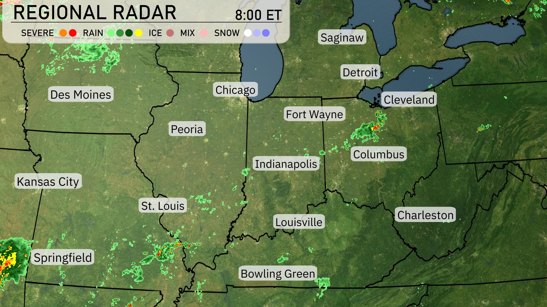
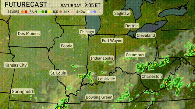
A cluster of showers is advancing northeastward across Springfield, bringing significant rainfall to central Missouri. Isolated thunderstorms are popping up near St. Louis and are tracking towards Indianapolis, potentially reaching Fort Wayne later today. Columbus and Cleveland are experiencing light rain, with storms gradually moving towards the eastern Great Lakes region. Detroit and Bowling Green enjoy clear skies with minimal cloud cover.
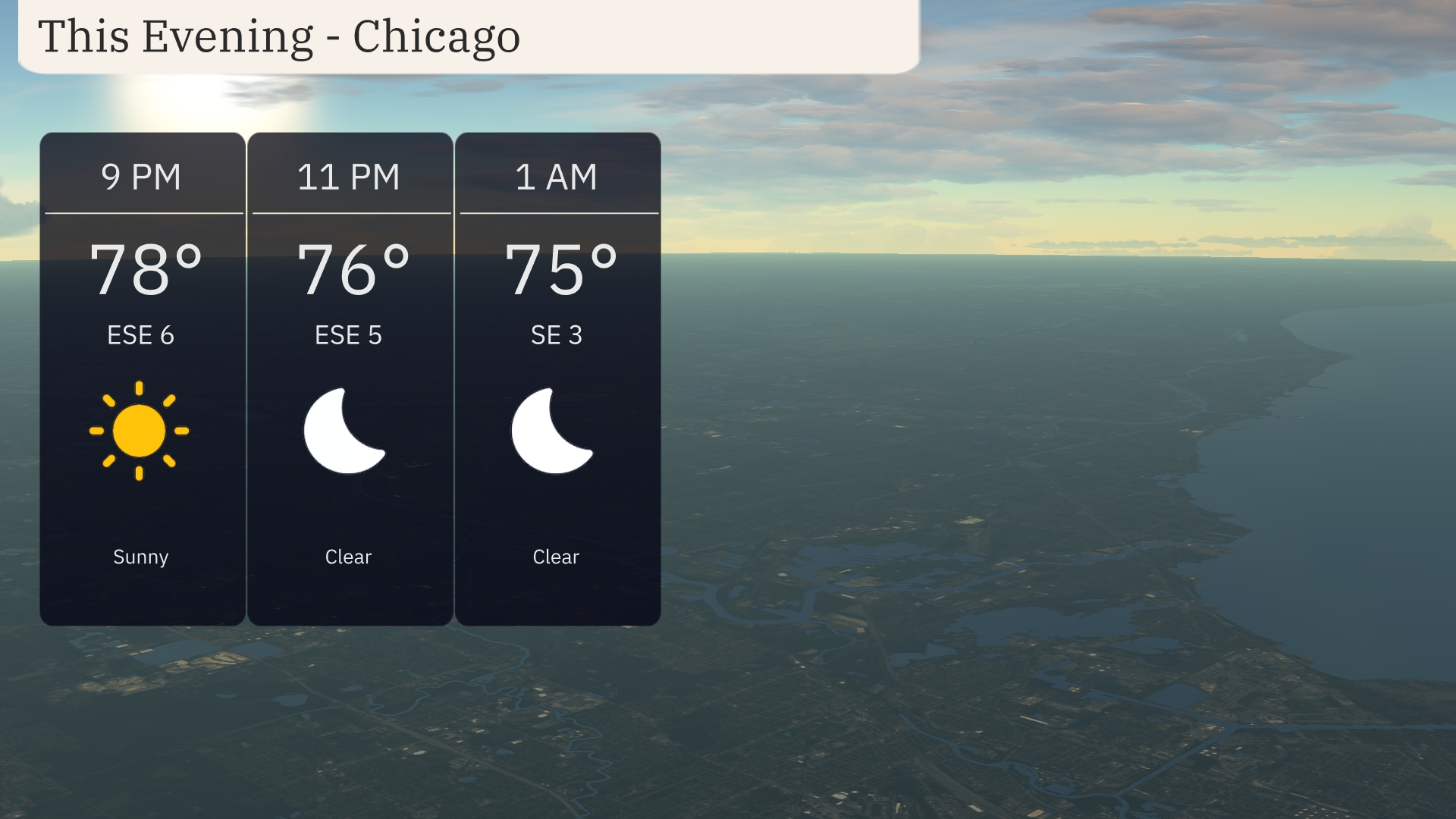
For this evening in Chicago, temperatures will start at a warm 78 degrees at 9 PM, gradually cooling to 75 degrees by 1 AM. Expect clear skies throughout the night, perfect for outdoor activities or stargazing. Winds will be gentle, coming from the east-southeast at 6 miles per hour early on, calming slightly as the evening progresses.
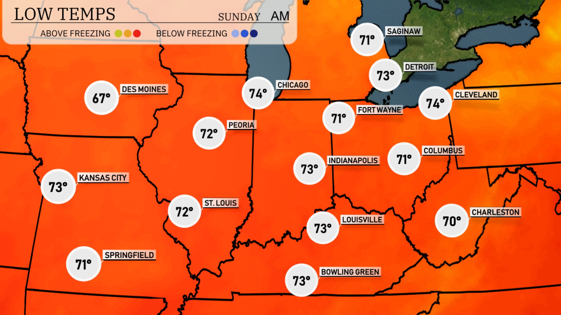
Tonight, Chicago will see a low of 74 degrees, while Peoria cools down to 72. Indianapolis will experience a mild night at 73 degrees, with Fort Wayne dropping slightly to 71. Expect Kansas City to settle at 73 degrees, and Louisville will match that at 73 as well.
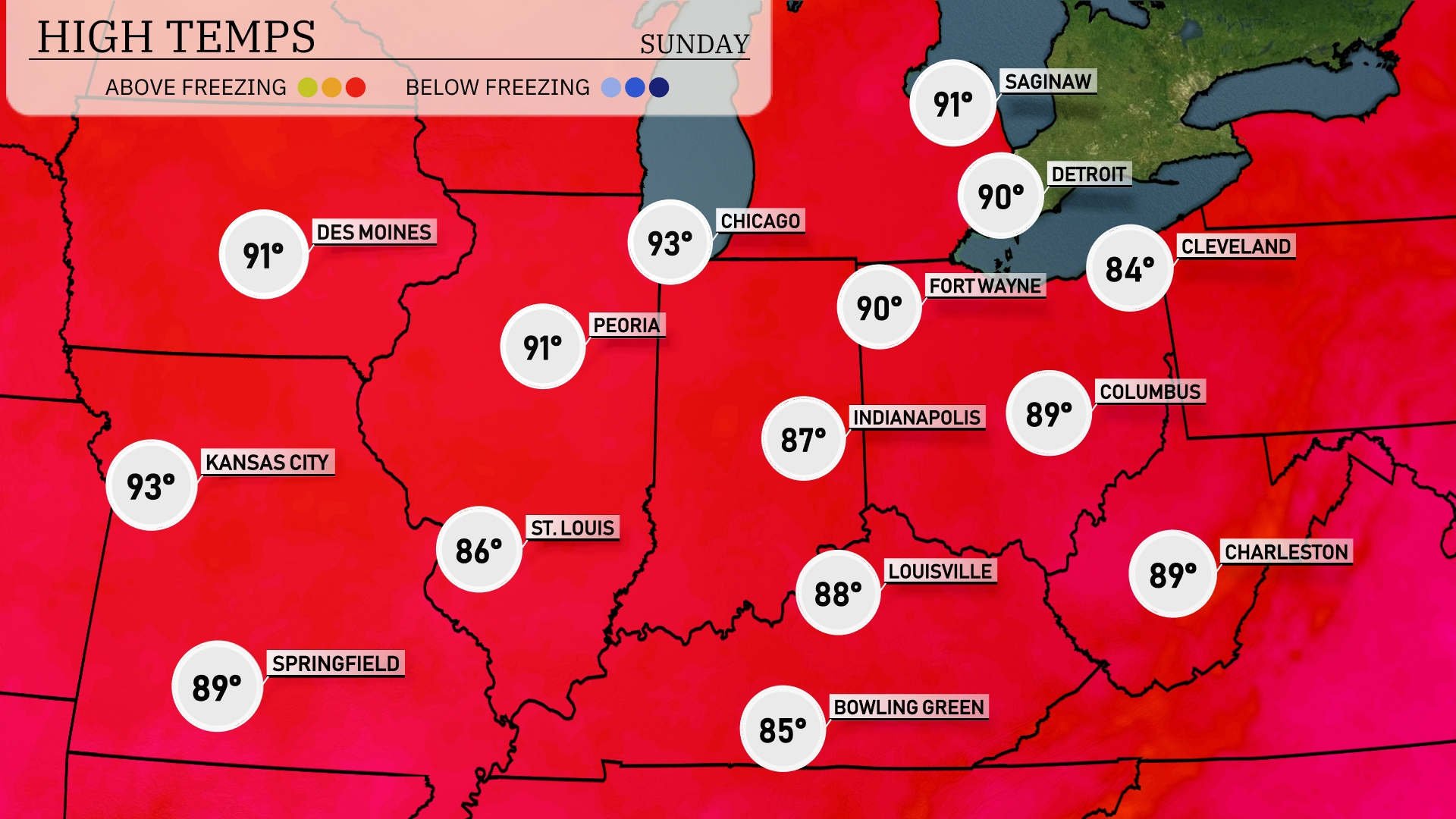
Tomorrow, high temperatures in the Midwest will be notably warm, with Kansas City reaching 93 degrees. Chicago is also expected to see a high of 93, while Peoria will hit 91. Indianapolis will be slightly cooler at 87 degrees, and St. Louis will reach 86. These temperatures are generally above average for this time of year, influenced by a strong high-pressure system lingering over the region, keeping conditions dry and sunny.
A series of storms will pass through the Midwest this weekend, starting overnight and intensifying into Saturday. Strong thunderstorms are expected primarily in southern Indiana and northern Kentucky, with localized heavy rain. Expect scattered showers extending into Chicago and Detroit. The cold front behind these storms will bring much cooler temperatures by Sunday, with potential wind gusts adding to brisk conditions. Stay alert for possible severe weather warnings, particularly in areas from Indianapolis to Bowling Green.
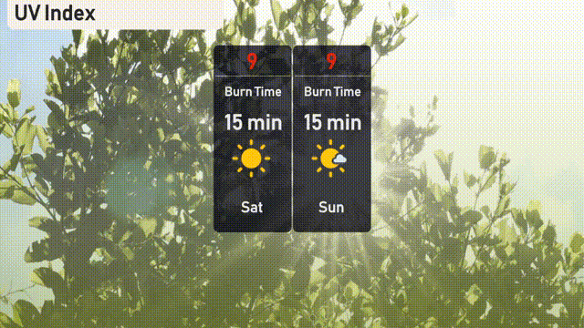
The UV index in Chicago is expected to reach very high levels of 9 both today and tomorrow, with a burn time in direct sunlight of just 15 minutes.
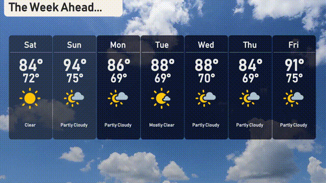
Saturday: Clear skies with the temperature climbing to a high of 84 degrees, cooling down to 72 degrees at night.
Sunday: Partly cloudy conditions with a high of 94 degrees and a low of 75 degrees.
Monday: Mostly sunny with a high of 86 degrees and the temperature dipping to 69 degrees overnight.
Tuesday: Look forward to a mostly clear day, peaking at 88 degrees with the low staying around 69 degrees.
Wednesday: Another partly cloudy day with temperatures hitting 88 degrees, and overnight lows at 70 degrees.
Thursday: The clouds linger, bringing in slightly cooler weather at 84 degrees for the high, with the low at 69 degrees.
Friday: Partly cloudy, warming up into the weekend with a high of 91 degrees and a low of 75 degrees.