July 2025: A Clear Gaze into Chicago and Midwest’s Summer Weather
By
Amy Freeze
Explore the active weather patterns shaping up across Chicago and the Midwest, from sunny skies to impending storms, in our comprehensive July 2025 forecast.
July brings dynamic changes to the Midwest’s weather, offering a mix of warmth, thunderstorms, and clear nights. Here’s what to expect in your city!
This month, we observe a significant variation in Midwest weather conditions. From high temperatures in Kansas City to showers spreading across Springfield and St. Louis, stay tuned for evening-to-evening updates and tips for handling sudden weather shifts. Also, remember to pay attention to UV safety as indexes soar up to 9 points!
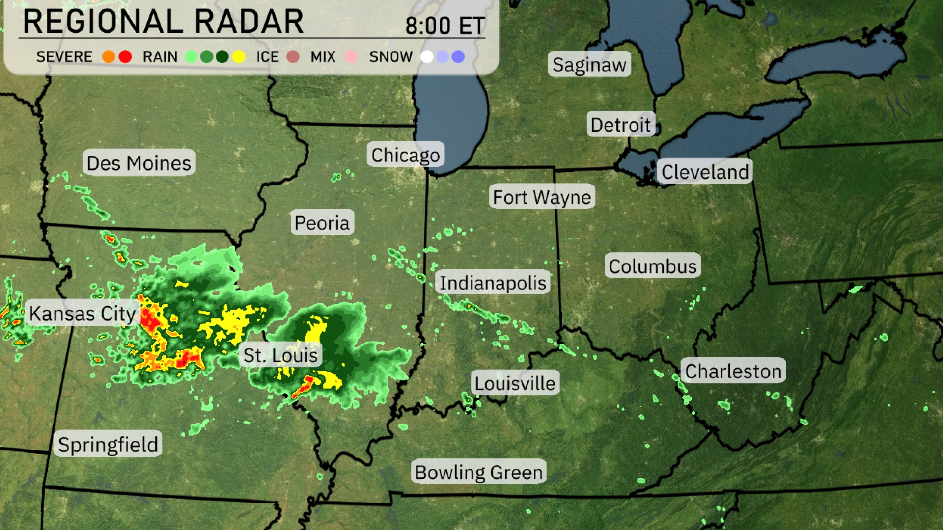
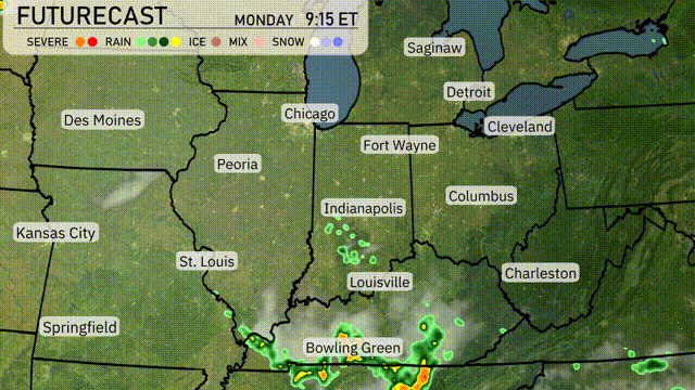
The Midwest region is seeing an active weather pattern today. Severe storms are developing near Kansas City, moving eastward toward St. Louis, with heavy rain and thunderstorms expected. Showers extend from St. Louis and reach into Springfield, while light rain is spreading toward Des Moines. Areas like Fort Wayne and Indianapolis are currently experiencing clear conditions under a blanket of clouds, with less precipitation in sight.
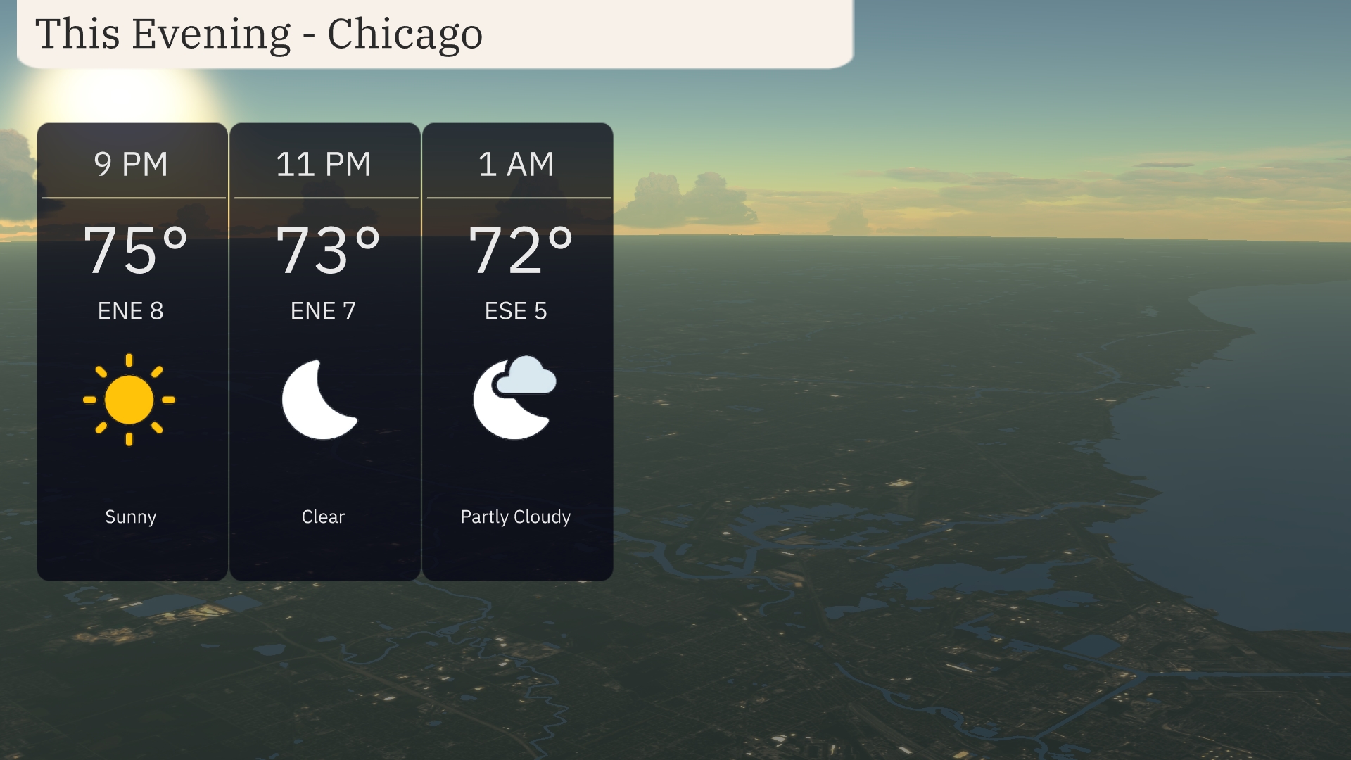
This evening in Chicago, enjoy a sunny start with temperatures at 75 degrees around 9 PM. As the night progresses, expect clear skies with temperatures slightly cooling to 73 degrees by 11 PM, accompanied by a gentle east-northeast wind around 7 mph. By 1 AM, skies become partly cloudy with temperatures reaching 72 degrees and winds from the east-southeast at 5 mph.
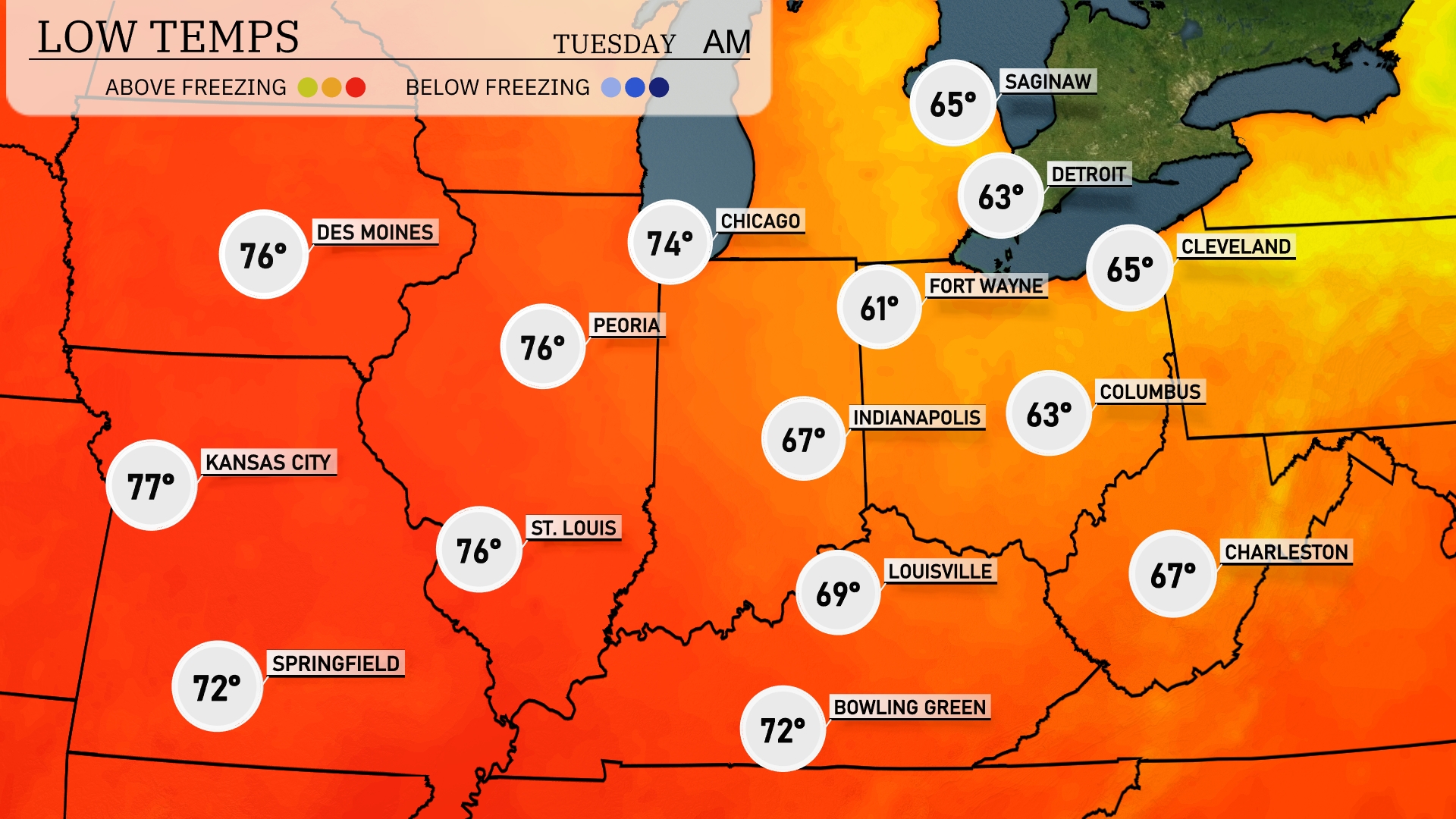
Tonight in the Midwest, expect low temperatures to dip significantly. Chicago will cool down to 74 degrees, while Indianapolis is forecasted to reach 67. Des Moines and Peoria will also see lows of 76 degrees, and Louisville is dropping to 69. Fort Wayne will be cooler at 61 degrees, marking a noticeable temperature shift for the region.
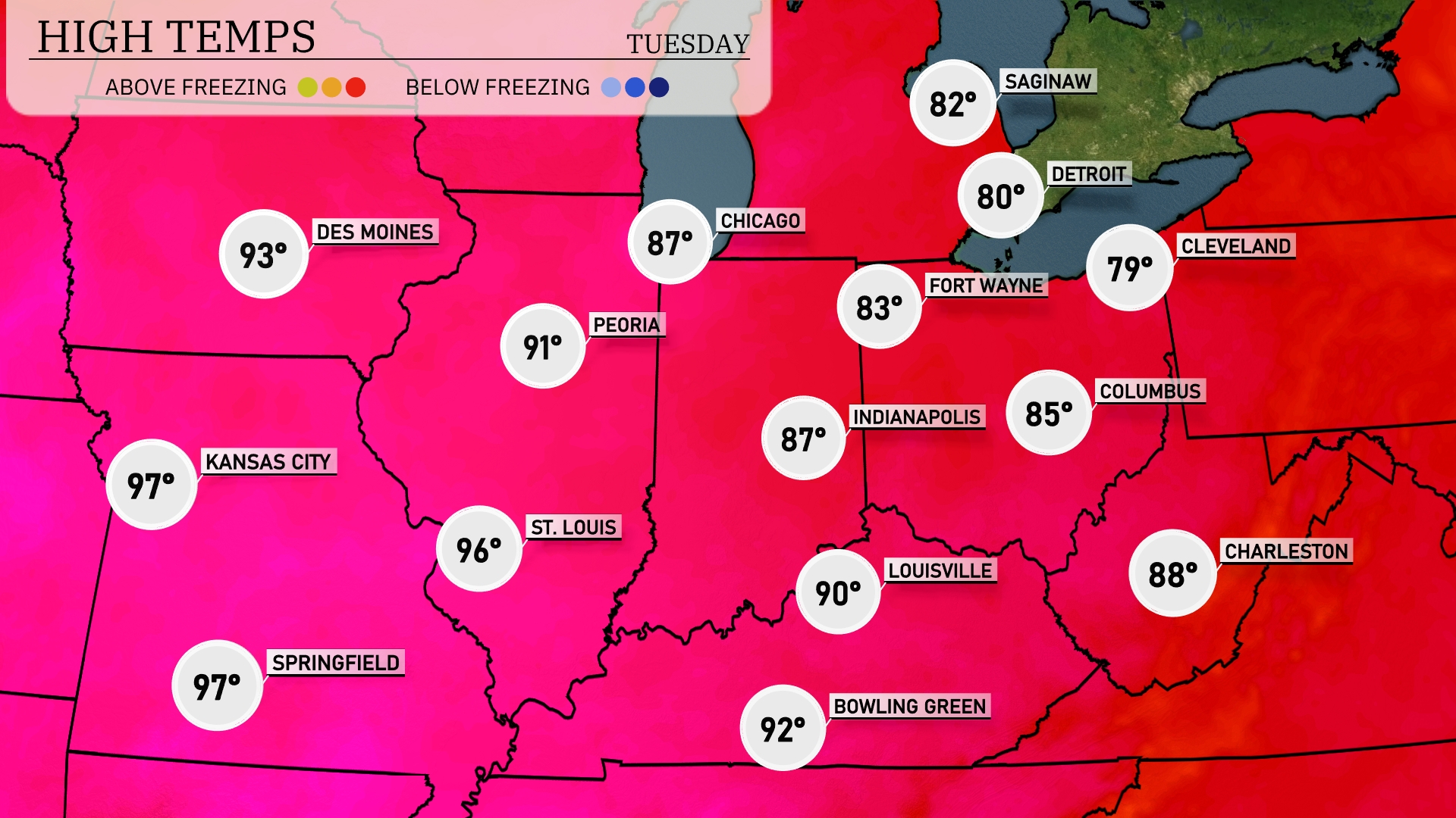
Tomorrow in the Midwest, Kansas City and Springfield will sizzle with highs reaching 97 degrees, well above average for this time of year. Peoria is expected to hit 91, while St. Louis warms up to 96 degrees. Chicago will see a pleasant high of 87, and Indianapolis is forecast to reach 87 as well.
A low-pressure system will move through the Midwest tomorrow, bringing scattered thunderstorms from St. Louis to Indianapolis. Expect heavy rain, particularly around Bowling Green, with the potential for localized flooding. Temperatures will remain in the low to mid-80s across the region. The risk of severe storms, including strong winds and hail, persists, especially in southern Indiana and western Kentucky. A cold front will pass late Tuesday, clearing skies and dropping temperatures slightly.
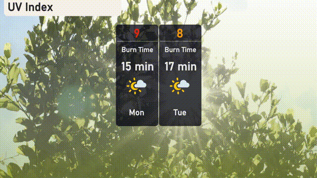
The UV index in Chicago will be very high today, reaching a value of 9, with a quick burn time of 15 minutes. Make sure to apply sunscreen and limit sun exposure to protect your skin. For tomorrow, the UV index remains high at 8, with a burn time of 17 minutes.
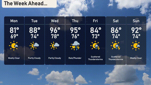
For the 7-day forecast in Chicago:
Monday: Mostly clear skies with a high of 81 degrees and a low of 69 degrees.
Tuesday: Enjoy partly cloudy conditions with temperatures reaching up to 88 degrees and a low of 74 degrees.
Wednesday: Partly cloudy once again, peaking at 86 degrees during the day, cooling to 74 degrees at night.
Thursday: Expect rain and thunder with a high of 95 degrees and a low of 76 degrees.
Friday: Prepare for scattered thunderstorms with temperatures reaching a high of 84 degrees and a low of 73 degrees.
Saturday: More scattered thunderstorms are expected, with a high of 86 degrees and the low staying around 74 degrees.
Sunday: The skies clear up a bit, offering mostly clear conditions and a warmer day, reaching up to 92 degrees with a low of 74 degrees.