Chicago Morning Glow to Afternoon Thunder: Weather Insights Across the Midwest
By
Amy Freeze
Explore a comprehensive overview of the varied weather patterns impacting Chicago and the Midwest, from delightful sunny mornings to unexpected stormy afternoons.
Expect a sunny start in Chicago with skies gradually clouding over. Detailed insights into the Midwest’s weather patterns as storms move eastward!
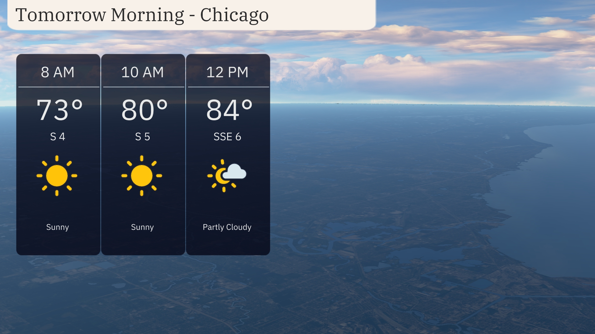
The city of Chicago is set to enjoy a sunny morning with temperatures beginning at a pleasant 73°F, climbing to 84°F by noon with partly cloudy conditions setting in. Moving beyond the city, the Midwest predicts tumultuous weather, including strong thunderstorms toward Des Moines and soothing rains over Cleveland. Dive into our full analysis of temperatures and weather trends throughout the region, and learn how to navigate the shifting skies from one day to the next.
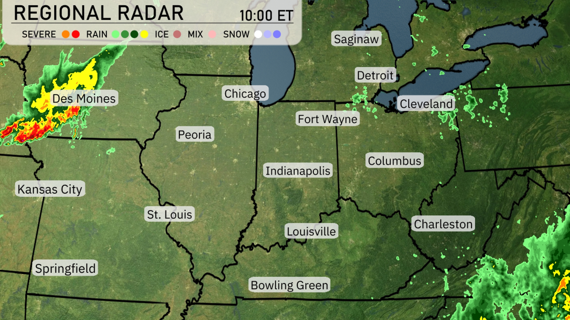
Strong thunderstorms are developing near Des Moines, moving eastward into central Iowa, indicating a wet afternoon ahead for the region. Rain showers are scattered across Cleveland, bringing some moisture that extends toward Detroit. Peoria and Indianapolis remain under cloudy conditions with minimal precipitation expected for now. Bowling Green is experiencing clear skies with no immediate weather threats.
Expect a sunny start to tomorrow morning in Chicago with temperatures beginning at 73 degrees by 8 AM. As the morning progresses, the temperature will rise to 80 degrees by 10 AM with continued sunshine. Winds will be steady, coming from the south at 5 miles per hour. By late morning around 12 PM, anticipate partly cloudy skies with temperatures reaching 84 degrees and a south-southeast wind at 6 miles per hour.
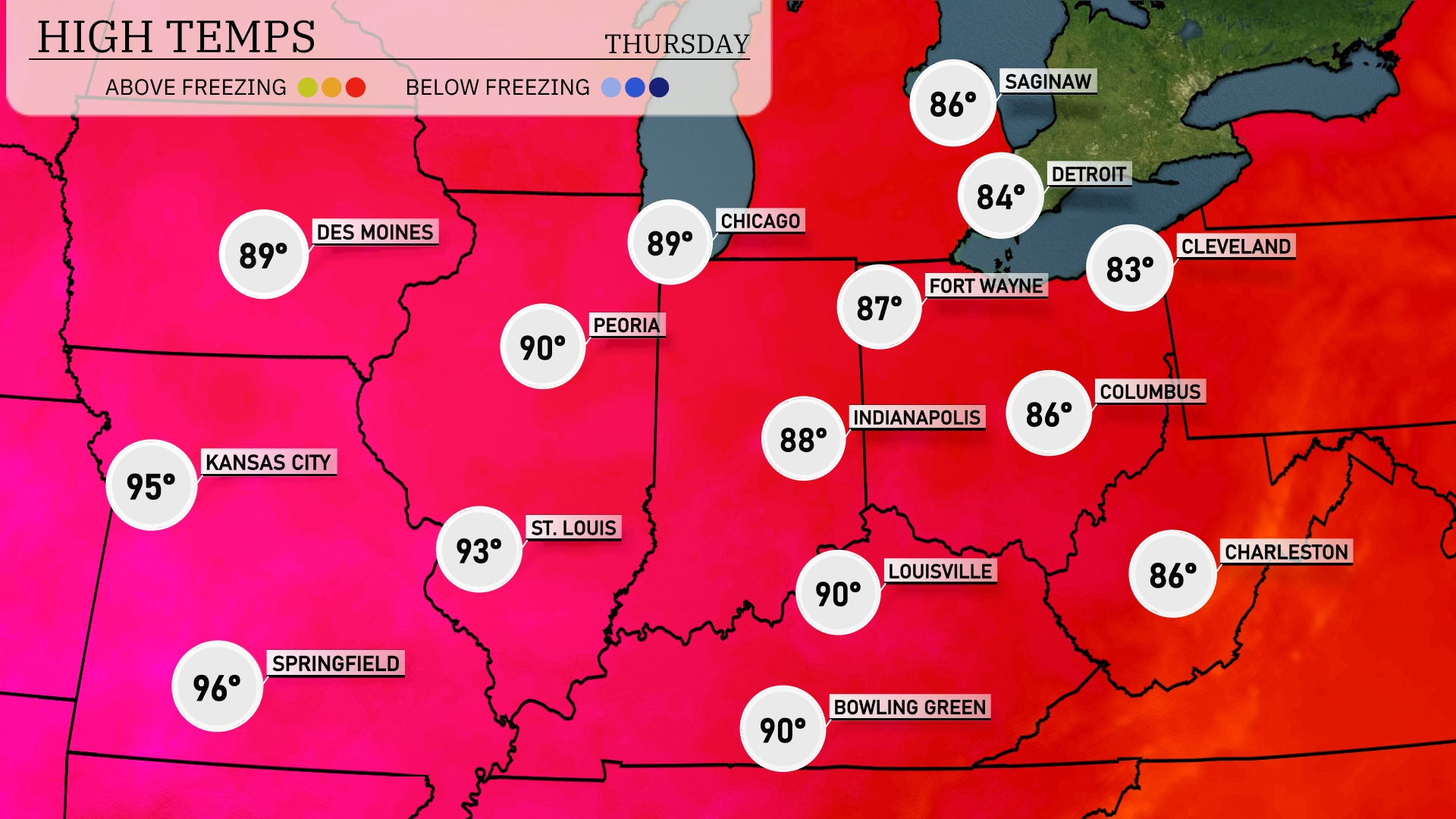
Tomorrow, Kansas City will see a high of 95 degrees, while St. Louis reaches up to 93. Peoria will be warm at 90 degrees, and Indianapolis can expect a high of 88. In the northern part of the region, Chicago and Des Moines will experience highs of 89 degrees.
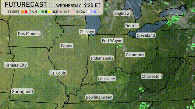
A low-pressure system moves across the Midwest, bringing widespread showers and thunderstorms, particularly from Des Moines to Fort Wayne, through Wednesday evening. Expect localized heavy rainfall in Indianapolis and Columbus, which could lead to minor flooding in low-lying areas. Temperatures range from the mid-70s in Chicago to the low 80s further south in cities like St. Louis and Louisville, with a cooler and drier air mass arriving by Thursday. A cold front pushes through boosting winds and causing some instability, which might trigger isolated severe storms specifically in areas like Fort Wayne and Peoria.
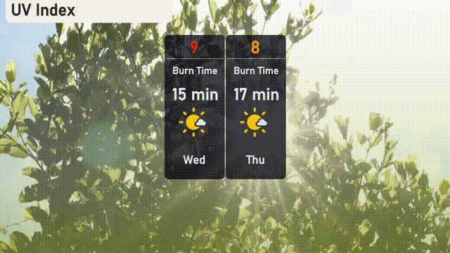
Chicago’s UV index will reach a high of 9 on Wednesday, providing a strong sun exposure with a burn time of about 15 minutes in direct sunlight. Moving into Thursday, the index lowers slightly to 8, with a burn time extending to 17 minutes.
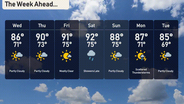
For the 7-day forecast in Chicago:
Wednesday: Expect partly cloudy skies with a high of 86 degrees and a low of 71 degrees.
Thursday: Warm temperatures continue with partly cloudy conditions, reaching a high of 90 degrees and cooling to a low of 73 degrees.
Friday: Mostly clear with a high of 91 degrees and a low of 75 degrees.
Saturday: Showers are likely late in the day, with temperatures peaking at 92 degrees and dropping to 75 degrees.
Sunday: Partly cloudy on Sunday with a high of 88 degrees and a low of 75 degrees.
Monday: Watch for scattered thunderstorms, with highs around 87 degrees and lows of 71 degrees.
Tuesday: The week wraps up with partly cloudy skies and a high of 85 degrees, dropping to a low of 69 degrees.