Riding the Midwest Weather Wave: From Chicago Sunrise to Stormy Nights
By
Amy Freeze
Explore the fluctuating conditions of the Midwest's weather from tranquil mornings in Chicago to a tempestuous evening across the region. Dive into our comprehensive guide for the next 7 days.
Take a quick look at Chicago’s morning forecast and the wider Midwest weather trends, including severe storm potential and significant temperature changes. Stay informed!
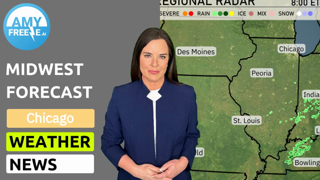
Join Meteorologist Amy Freeze as she guides through Chicago’s morning conditions and highlights significant weather trends across the Midwest. From heavy rain in Bowling Green to clear skies in Chicago, understand what to expect and how to prepare for temperature drops and potential thunderstorms. All the details for the next 7 days, straight from your trusted weather expert!
The Midwest region is seeing a combination of rain and severe weather activity, especially around Bowling Green with storms pushing northeast. Louisville is under persistent rain, while Indianapolis experiences overcast, damp conditions. Fort Wayne and Columbus also have significant cloud cover with light precipitation. Detroit and Cleveland should prepare for scattered showers moving eastward. Clear conditions are present near St. Louis and Chicago as they enjoy a respite from the rain, offering a brighter start to the day.
In Chicago tomorrow morning, expect cloudy skies with temperatures starting at 55 degrees at 8 AM. Winds will be coming from the west-southwest at around 14 miles per hour. By 10 AM, the temperature will rise slightly to 56 degrees with winds increasing to 18 miles per hour from the west. By noon, temperatures will reach 58 degrees with winds maintaining a steady pace at 19 miles per hour.
High temperatures for the Midwest tomorrow will show a warming trend, with many areas experiencing readings well above average. Kansas City and St. Louis both reach 77 degrees, while Springfield warms up even more to 81 degrees. Indianapolis is expected to see a high of 69 degrees, slightly below the seasonal average. Louisville also matches Kansas City at 77 degrees, and Bowling Green stands out with a notable high of 85 degrees.
A cold front is set to sweep across the Midwest from Des Moines to Louisville late Friday evening, bringing with it a band of thunderstorms, heavy rain, and potentially damaging winds. Keep an eye on the possibility of localized flooding due to the intense rainfall expected overnight. By Saturday, the storm system will shift eastward, affecting cities from Chicago to Indianapolis with lingering showers. Temperatures will take a dip post-front, with notably cooler conditions settling in for the weekend.
In Chicago on Friday, the UV index will be high at 8, with a quick burn time of just 17 minutes. On Saturday, the UV index decreases to 5, with sunburn possible in about 27 minutes. Remember to take sun precautions on bright days!
For the 7-day forecast in Chicago:
Friday: Cloudy with a high of 87 degrees and a low of 54.
Saturday: Partly cloudy, cooling down to a high of 67 degrees and a low of 50.
Sunday: More sunny intervals with a high of 59 degrees and lows around 45.
Monday: Showers are expected later, with a high of 53 and a nighttime low of 48.
Tuesday: Continuation of rain showers, the high remains at 54 degrees with lows also at 48.
Wednesday: Mostly cloudy skies, the high is 52 degrees and the low is 46.
Thursday: Partly cloudy, warming slightly to a high of 58 degrees and a low of 47.