Chicago and the Midwest: A Week of Weather Wonders
By
Amy Freeze
Discover how Chicago's weather will balance sun and showers this week, with exclusive insights by meteorologist Amy Freeze.
Meteorologist Amy Freeze reports on the upcoming week’s weather in Chicago and the Midwest. Expect a mix of sun, clouds, and occasional rain. Read on for a day-by-day forecast!
In this comprehensive update, Amy Freeze guides you through a week of varied weather patterns across Chicago and the Midwest. From partly cloudy skies to cooler evenings and unexpected showers, each day brings something new. Dive into our detailed forecast to efficiently plan your week with predictions from a trusted meteorologist.
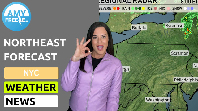
On the regional radar, the Midwest is currently witnessing a prominent line of rain showers stretching from Columbus through Fort Wayne and reaching up to Saginaw. This rain band also touches Detroit and is moving towards the eastern parts of the region, with occasional bursts of heavier rain indicated near Columbus. Cleveland is under light to moderate rain, with sections of the city experiencing brief increases in intensity. Meanwhile, cities like Chicago, Springfield, and St. Louis are enjoying clear and calm weather conditions, showing no significant precipitation or cloud cover at this time.
Chicago this afternoon will see temperatures holding steady, around 70 degrees at 4 PM, dipping slightly to 66 degrees by 8 PM. Expect mostly sunny skies turning partly cloudy as the afternoon progresses. Winds will be light, shifting from northwest at 8 mph to northeast at 4 mph by the evening.
Today’s regional high temperatures in the Midwest show a mix of warmth and cooler spots. In Des Moines, enjoy a pleasant high of 77 degrees. St. Louis and Peoria are also warm, hitting 72 and 75 degrees, respectively. Meanwhile, Indianapolis and Columbus are on the cooler side, with highs only reaching 58 degrees. Chicago sits comfortably at 72 degrees, aligning with the warm conditions in Kansas City at 76 degrees. The cooler air lingers towards the north, particularly in Fort Wayne with a high of 64 degrees.
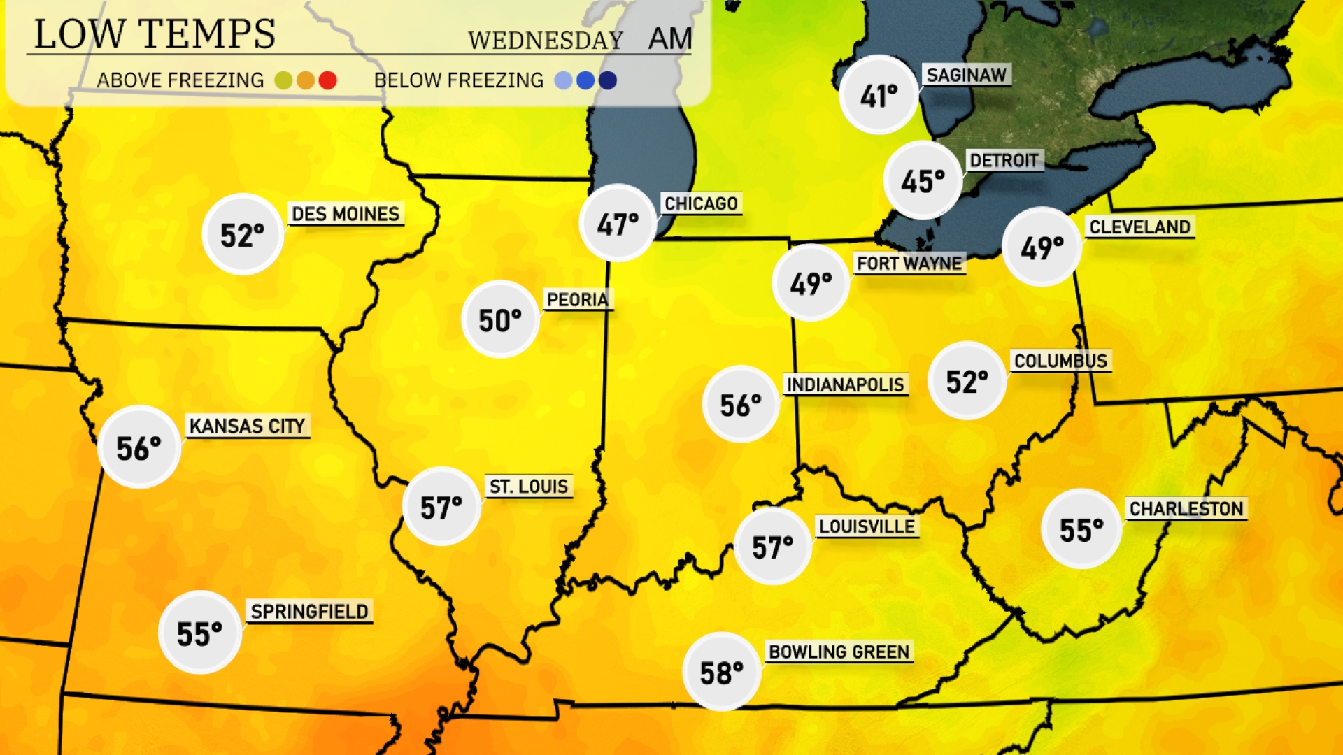
Tonight in the Midwest, temperatures will dip significantly, with Chicago falling to 47 degrees. Indianapolis is expected to reach a low of 56 degrees, while Fort Wayne will see a cooler temperature of 49. In the northern part of the region, Saginaw is looking at a chilly low of 41 degrees. Expect Louisville to stay relatively mild at 57 degrees, and Kansas City will wrap up the day with a low of 56.
Expect noticeably warm temperatures in the Midwest tomorrow, with many cities experiencing highs above the seasonal average. Chicago will see a high of 67 degrees, while Peoria reaches a striking 80 degrees. Indianapolis and Louisville are set to enjoy highs of 79 and 77 degrees, respectively. Kansas City’s temperature will be cooler at 67 degrees, and Cleveland lags behind at just 63 degrees. These temperatures reflect a trend of above-average warmth across the region, driven by high pressure moving in.
A cold front sweeps through the Midwest tomorrow, bringing widespread rain showers from St. Louis to Columbus by daybreak. Expect thunderstorms, especially across Indiana and Ohio, with isolated instances of strong winds. High temperatures will hover in the upper 60s to low 70s, but cooler air follows behind the front pushing into the low 60s by evening. The weather system clears out by late Wednesday, leaving drier conditions but staying vigilant for any updates regarding potential severe weather threats, particularly in Fort Wayne and Louisville.
The UV index in Chicago is at 0 for both days due to cloud cover. Sun exposure risks are minimal, and no significant UV rays will pose a threat. Enjoy the day without the usual sun protection measures!