Chicago’s Contrast: Sun Kissed Days and Stormy Nights
By
Amy Freeze
Explore the highs and lows of Chicago's weather this week—from balmy afternoons to chilly nights and unexpected thunderstorms. Tap in for daily updates!
This week in Chicago, find yourself under partly sunny skies with a tapestry of impending thunderstorms. From temperatures soaring up to 90 degrees to diving into cool nights, we’ve got it all covered!
The vibrant city of Chicago offers a dynamic weather pattern this week. Experience warm afternoons with temperatures reaching the high 80s and prepare as the evening brings cooler temperatures and the chance of isolated thunderstorms. Our detailed guide provides a day-by-day analysis, ensuring you’re prepared whether you’re planning an outing or staying cozy indoors. Follow along for live updates and expert forecasts right here.
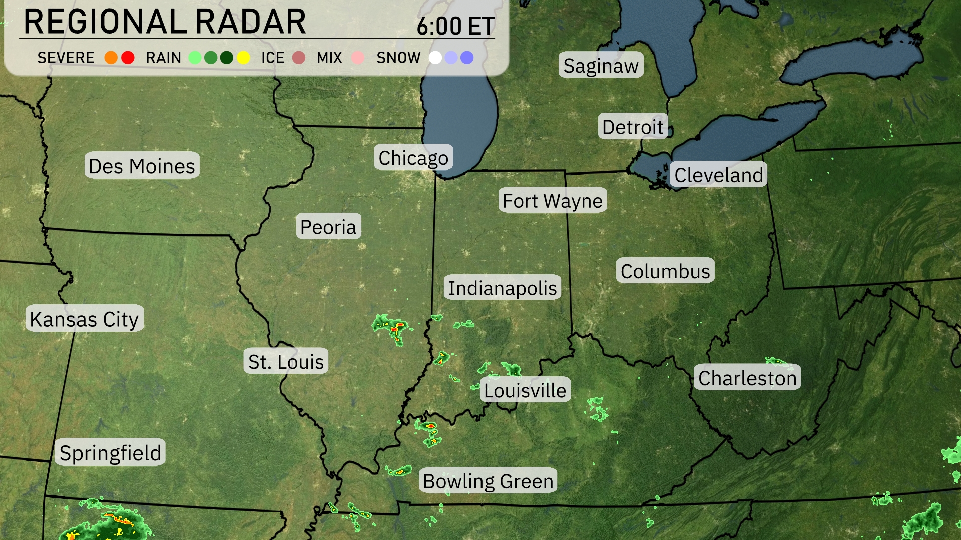
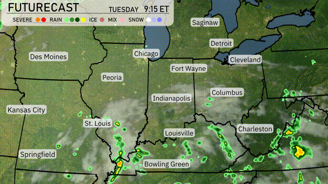
Showers are currently forming near St. Louis and moving eastward toward Indianapolis, bringing periods of moderate to heavy rain. Lighter rain showers are just north of Bowling Green, while scattered showers are also developing over parts of Cincinnati. Fort Wayne remains dry, but clouds are building. Clear conditions are prevailing for much of Chicago and Des Moines, offering a break from any precipitation.
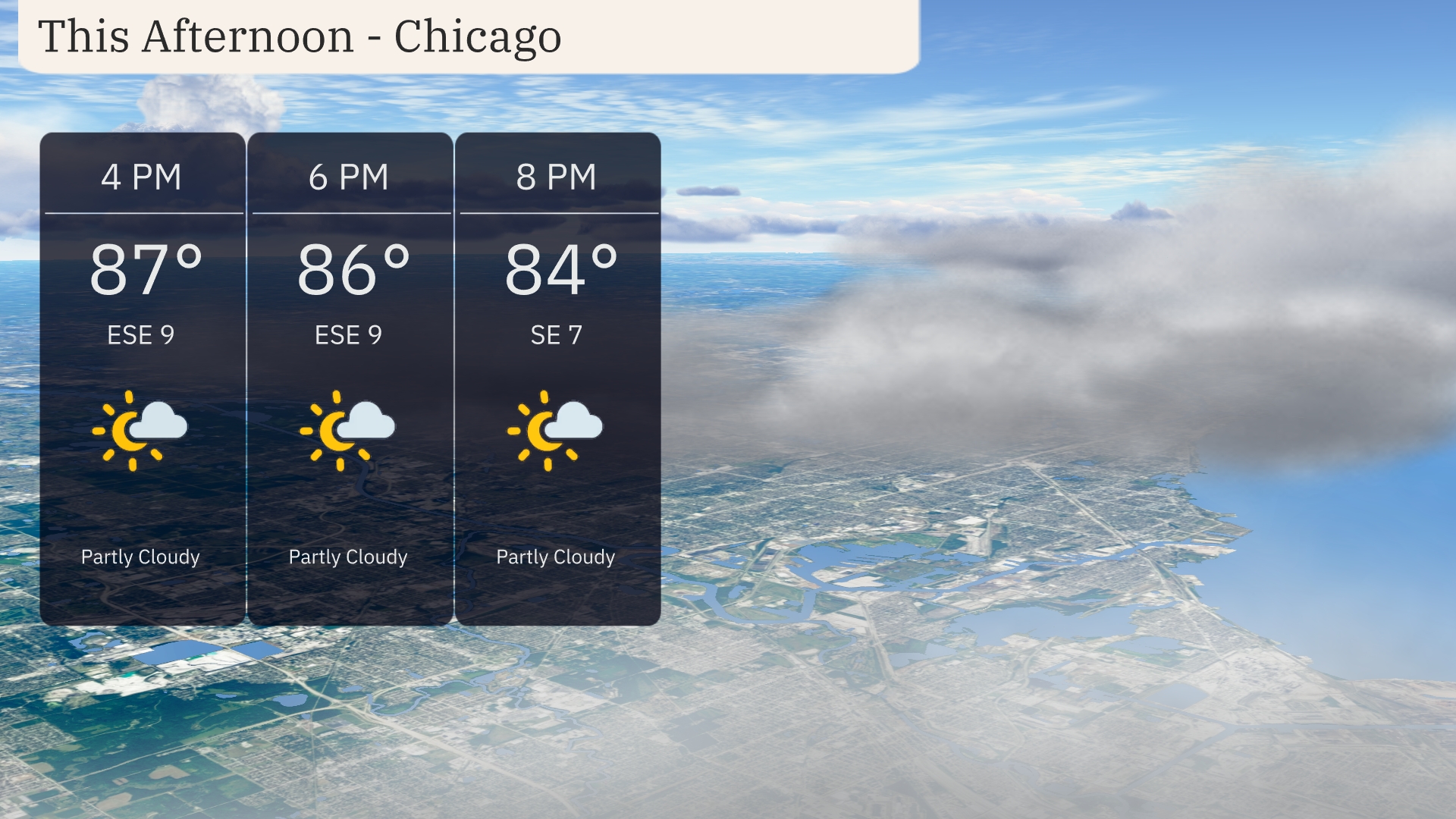
This afternoon in Chicago, temperatures will be warm, reaching 87 degrees by 4 PM with a light east-southeast wind around 9 miles per hour. Expect partly cloudy skies to continue through the evening. By 6 PM, the temperature slightly dips to 86 degrees, maintaining the gentle breeze. As you head into the evening, temperatures remain comfortable at 84 degrees by 8 PM with skies staying partly cloudy.
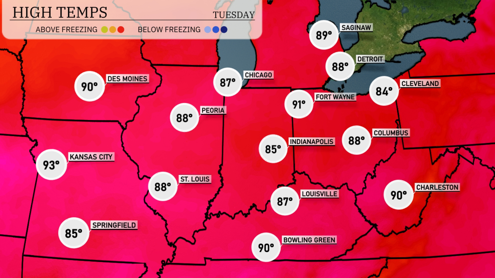
In the Midwest today, temperatures are reaching into the upper 80s to low 90s. Kansas City is leading the pack with a high of 93 degrees, while St. Louis will see a warm afternoon at 88. Indianapolis remains on the cooler side at 85, but Fort Wayne is not far behind at 91. Chicago enjoys a pleasant day with a high of 87, and Peoria rounds it out at 88 degrees.
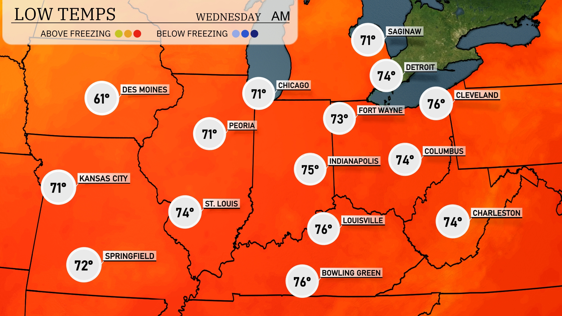
Tonight in the Midwest, temperatures are expected to dip significantly. Chicago will see a low of 61 degrees, while Des Moines is set to cool down to 61 as well. Indianapolis will experience a low of 63 degrees, with St. Louis not far behind at 64 degrees. Expect a chilly night in Kansas City with a low of 61 degrees.
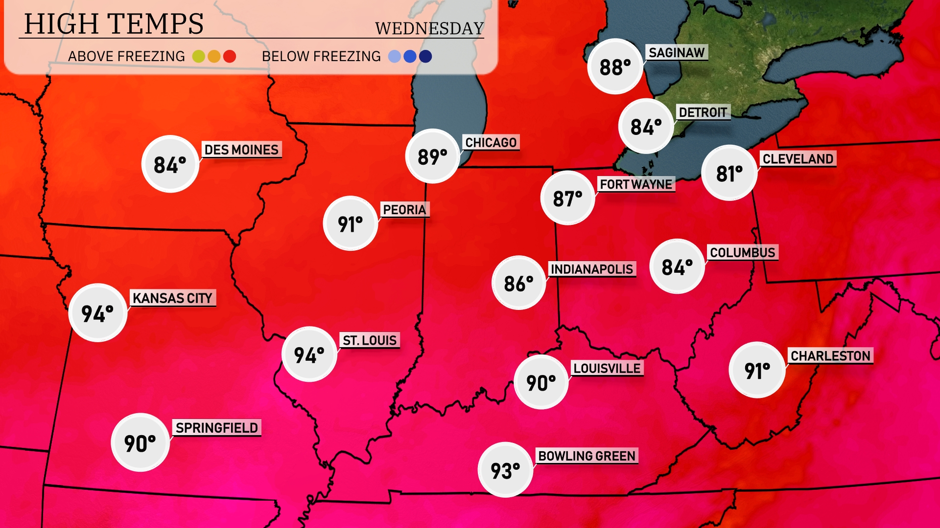
Tomorrow in Kansas City, expect a sizzling high of 94 degrees, matching temperatures in St. Louis. Springfield will reach a warm 90 degrees, while Peoria is slightly warmer at 91 degrees. In Indianapolis, temperatures will hit 86 degrees, bringing a touch of summer heat to the Midwest. Notably, Chicago will see highs around 89 degrees, indicating above-average readings throughout the region as warm air continues to push northward.
A cold front moving through the Midwest tomorrow brings scattered thunderstorms, especially across Indiana, Kentucky, and into Ohio. Expect locally heavy rains with potential for gusty winds, primarily in the afternoon and evening. Temperatures will dip slightly behind the front, but most areas will remain warm, with highs in the upper 80s. While severe storms are not expected to be widespread, stay weather-ready for isolated cases of strong storms or brief flooding due to intense downpours. Clear skies return into Wednesday, followed by another round of showers by Thursday afternoon.
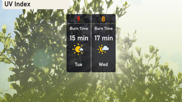
Chicago’s UV index today is a high 9, with a burn time of just 15 minutes under direct sunlight. On Wednesday, the index slightly decreases to 8, extending the burn time to 17 minutes.