From Sun to Storms: Chicago’s Dynamic Weather Week Ahead
By
Amy Freeze
Explore an in-depth forecast of Chicago’s weather, ranging from sunny days to impending thunderstorms, with insights from meteorologist Amy Freeze.
Check out the full update on Chicago’s week in weather from sunny skies to stormy evenings with tips on how to stay safe during severe weather conditions.
Greetings, Chicagoans and Midwest residents! Meteorologist Amy Freeze here with your detailed weekly weather forecast. This week in Chicago, expect a mix of sunny days and stormy evenings. Keep an eye out for Thursday’s partly cloudy conditions and brace for potential severe weather heading our way by the weekend. Get all the insights right here and learn how to prepare for sudden weather shifts!
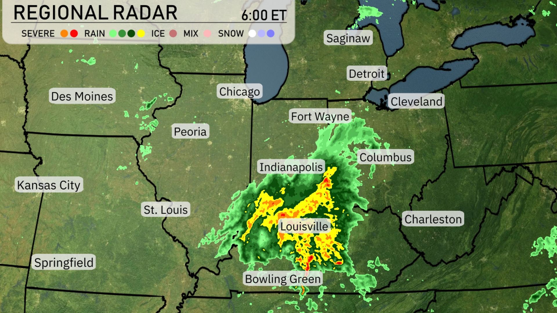
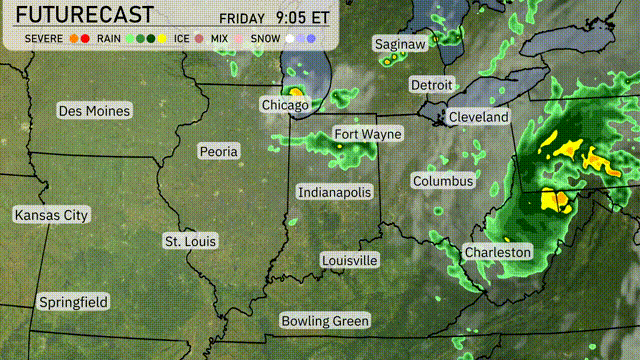
The regional radar shows Midwest rain, particularly affecting areas from Indianapolis to Louisville. Louisville is currently under intense rain, with a line of showers extending northeast through Fort Wayne. Cleveland’s skies are turning gray as rain approaches from the southwest. Light rain is reaching southern Detroit, while Chicago remains dry with cloud cover moving in. Springfield is seeing clear skies, away from the precipitation-heavy zone centered over Indiana and western Ohio.
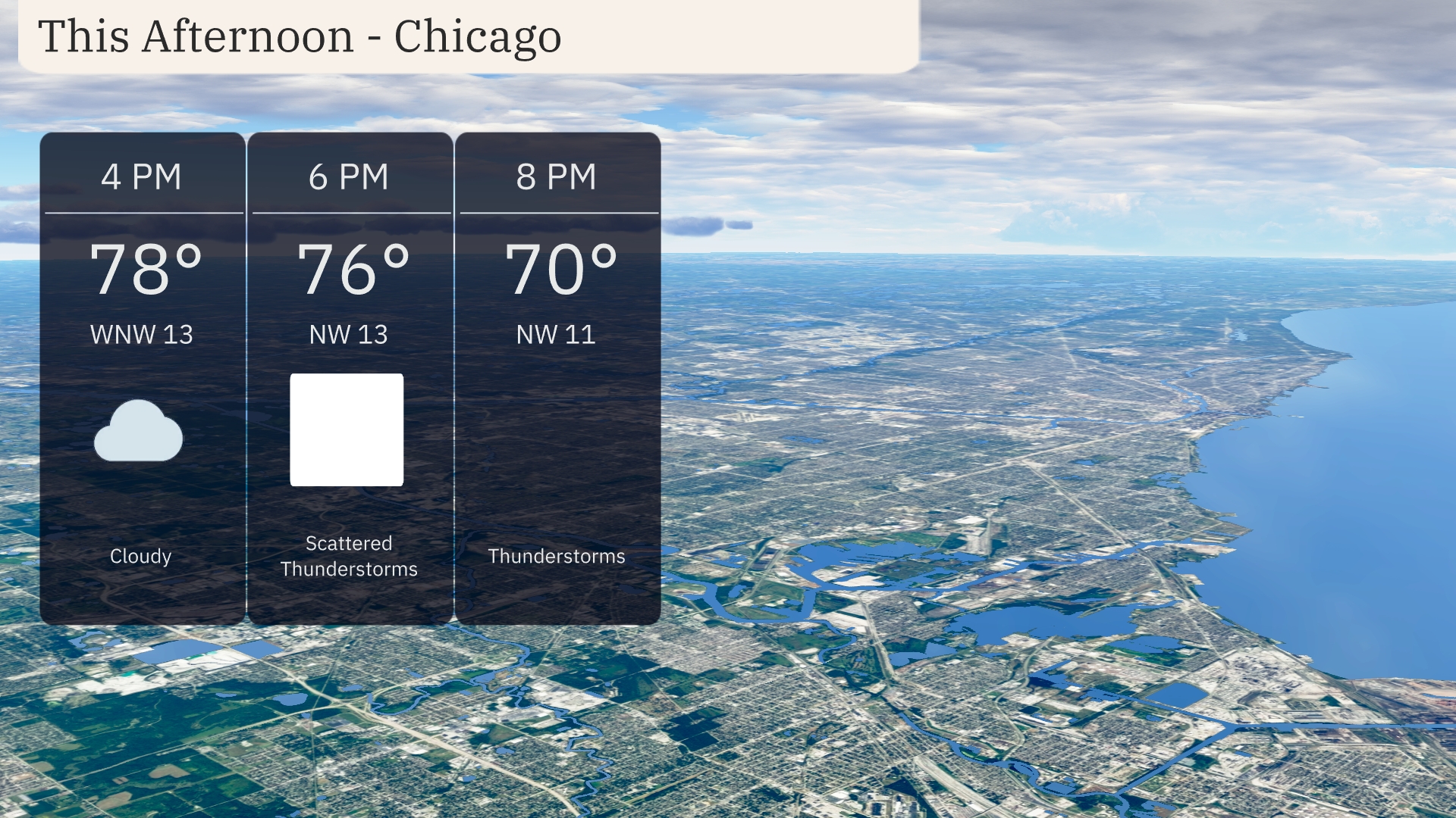
In Chicago this afternoon, the temperature will be around 78 degrees under cloudy skies with a west-northwest wind at 13 miles per hour. By 6 PM, scattered thunderstorms are expected as temperatures slightly drop to 76 degrees, with the wind maintaining its westerly pattern. Thunderstorms will continue into the evening, and temperatures will fall to 70 degrees by 8 PM, as the wind shifts to 11 miles per hour.
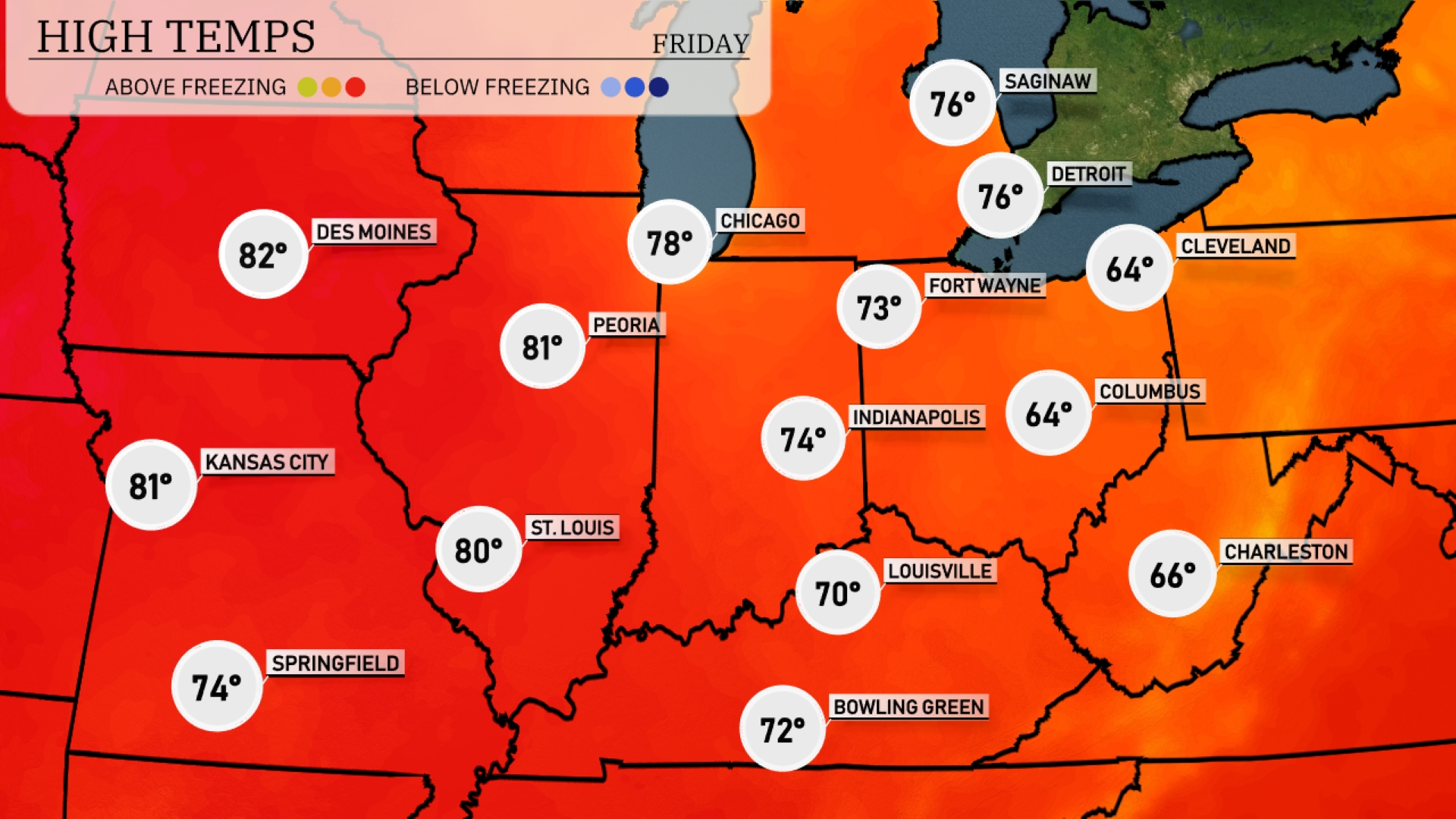
In the Midwest today, temperatures are running warm. St. Louis leads the pack with a high of 80 degrees, while nearby in Kansas City, expect a high of 81. Chicago is slightly cooler at 78 degrees, and Peoria matches that warmth with another high of 81. Indianapolis will reach 74 degrees, creating a comfortable afternoon. In stark contrast, Cleveland remains quite cool with a high of only 64.
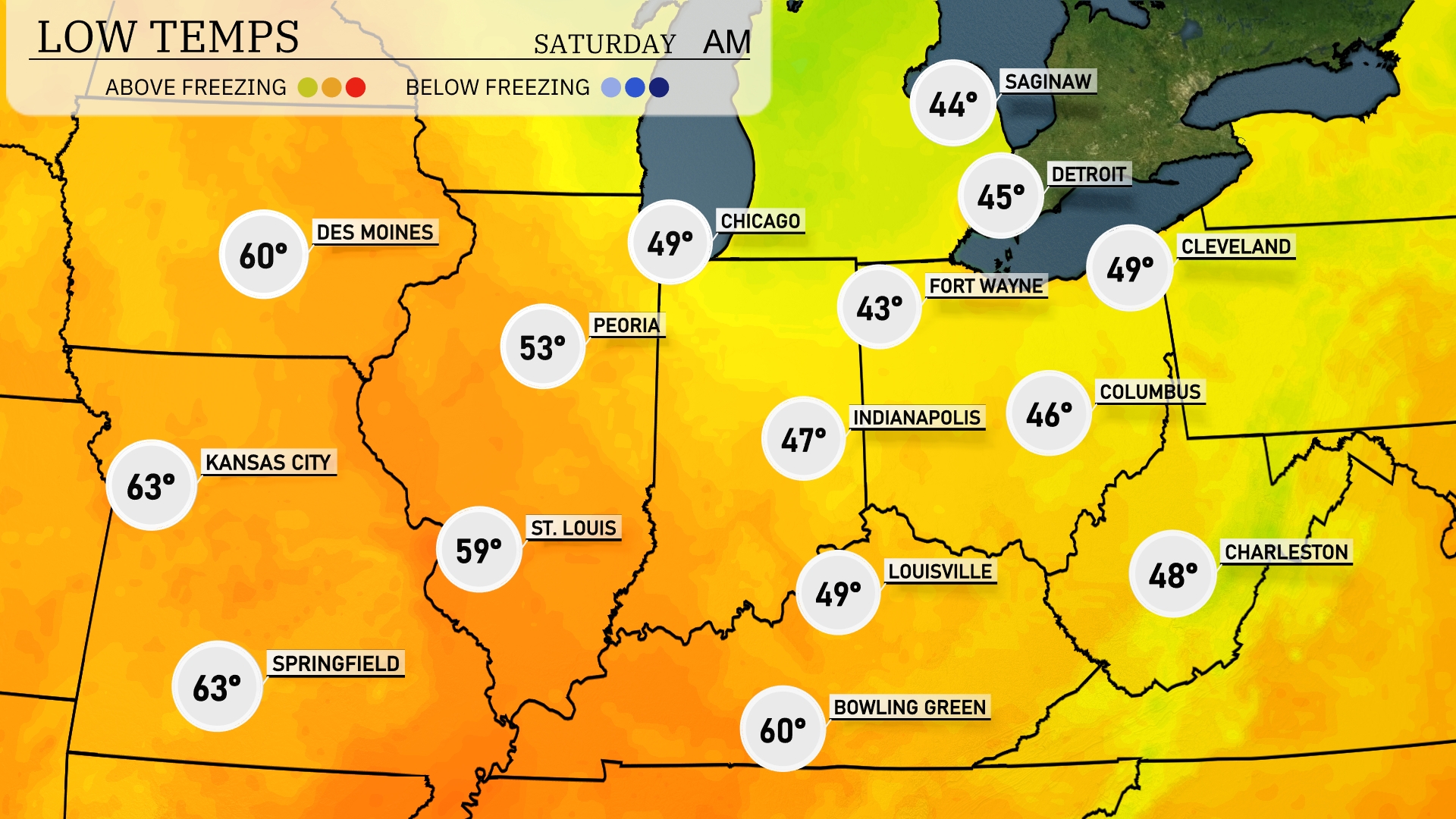
Tonight Chicago will see a low of 49 degrees, while Indianapolis will cool down to 47. Notably, Fort Wayne is forecasted to drop to 43, making it one of the cooler spots. Cleveland will record a low of 49 degrees.
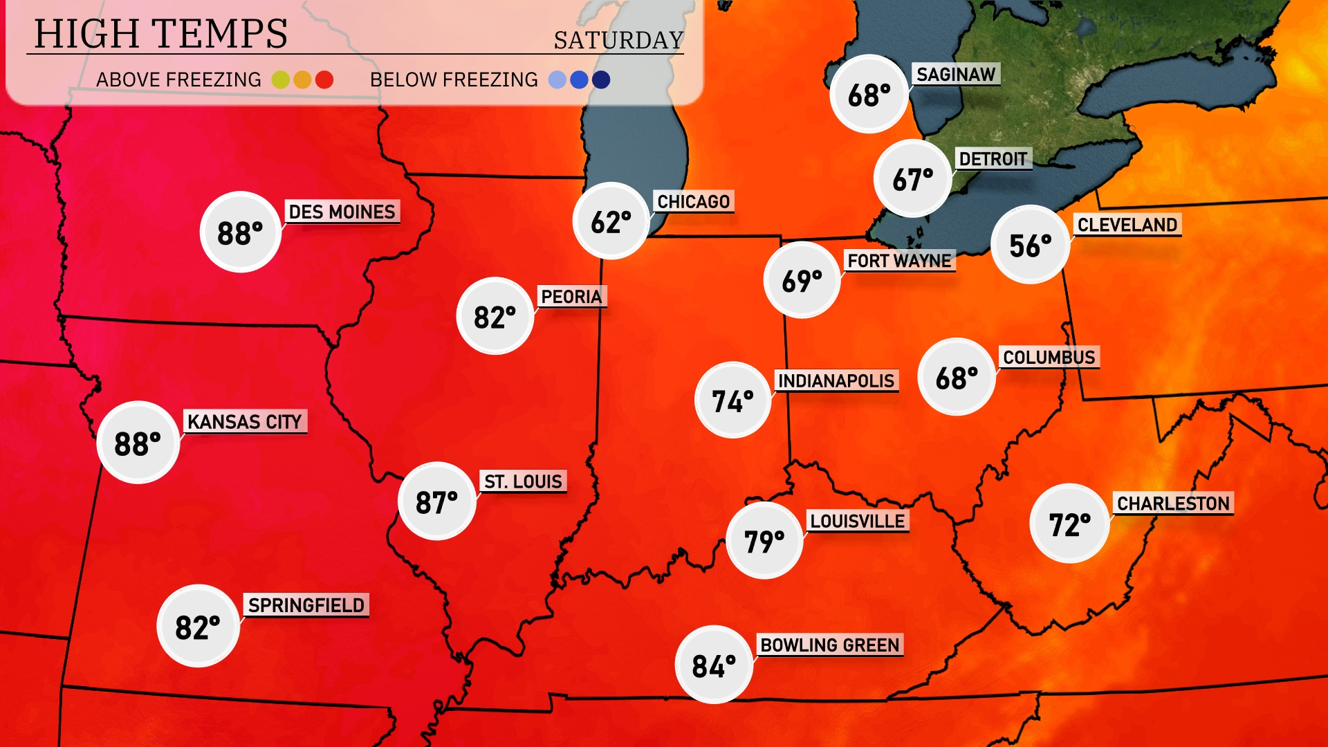
Tomorrow Kansas City will see a high of 88 degrees, while St. Louis isn’t far behind at 87. Chicago is cooler, hitting 62 degrees, with Indianapolis reaching 74. Further south, Louisville will warm up to 79 degrees, and Bowling Green will enjoy a high of 84.
A cold front is set to move through the Midwest tomorrow, bringing scattered thunderstorms from Kansas City to Detroit, mostly in the evening hours. Expect heavy rainfall along with isolated severe storms, particularly near Chicago and Indianapolis. While temperatures will drop slightly behind the front, prepare for local flooding in low-lying areas due to potential downpours. The front progresses eastward, leaving clear skies towards St. Louis and Louisville by late Friday.
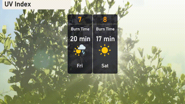
The UV index in Chicago on Friday will reach a high of 7, with a burn time around 20 minutes in exposure, indicative of a strong sun. Despite Saturday’s cloudy skies, the UV index climbs to 8, reducing the burn time to just 17 minutes.