Chicago’s Meteorological Rollercoaster: High Heat Followed by Stormy Relief
By
Amy Freeze
Explore the swift weather transitions from clear, sunny skies to storm-filled evenings in Chicago. A complete breakdown of what to expect this week in the Midwest.
Chicago and the wider Midwest are experiencing a week of extreme weather fluctuations. From scorching heat above 90 degrees to late evening thunderstorms, understand how these conditions affect your daily plans.
In this detailed blog post, we delve into the nuanced weather patterns impacting Chicago and the Midwest. Learn about the specific forecasts from partly cloudy skies and severe storms in northern Illinois to tranquil conditions in the Ohio Valley. Plus, find out the best safety practices during these extreme weather shifts, from dealing with high UV indexes to preparing for potential flooding.
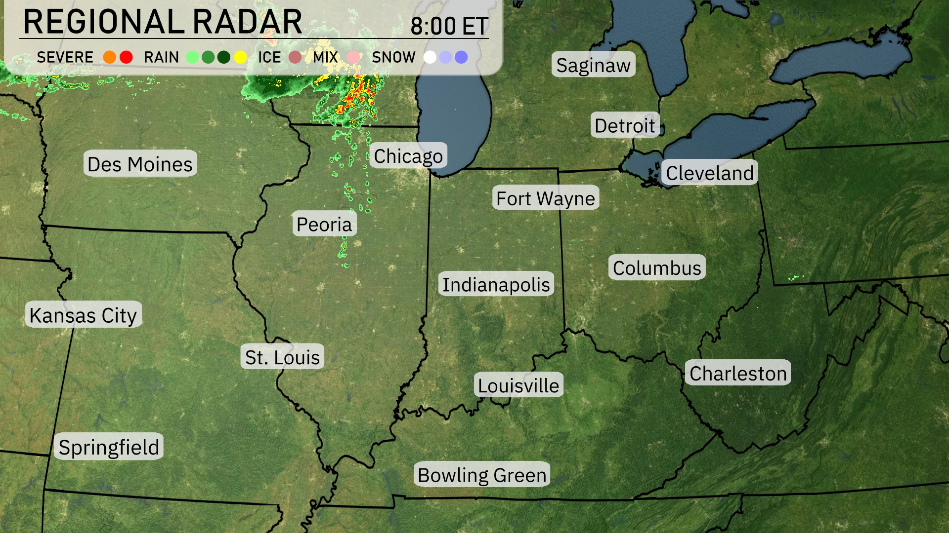
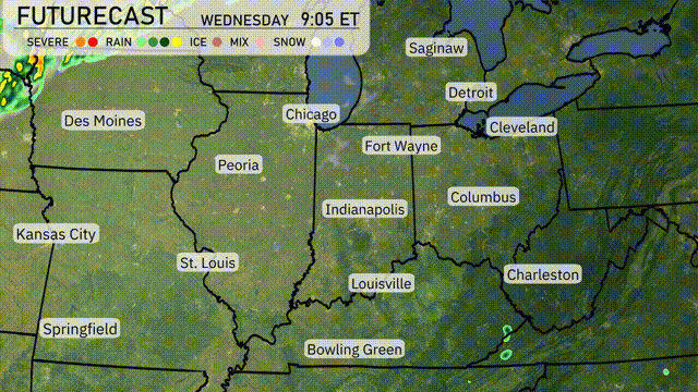
A cluster of severe storms is sweeping over northern Illinois, with heavy rainfall moving across areas like Chicago and Peoria. Parts of eastern Iowa, including Des Moines, are experiencing light rain showers pushing eastward. Meanwhile, Indianapolis and Fort Wayne are enjoying clear skies as the rain lingers west of the region. The Ohio Valley, covering areas like Cleveland and Detroit, remains tranquil with no immediate signs of precipitation.
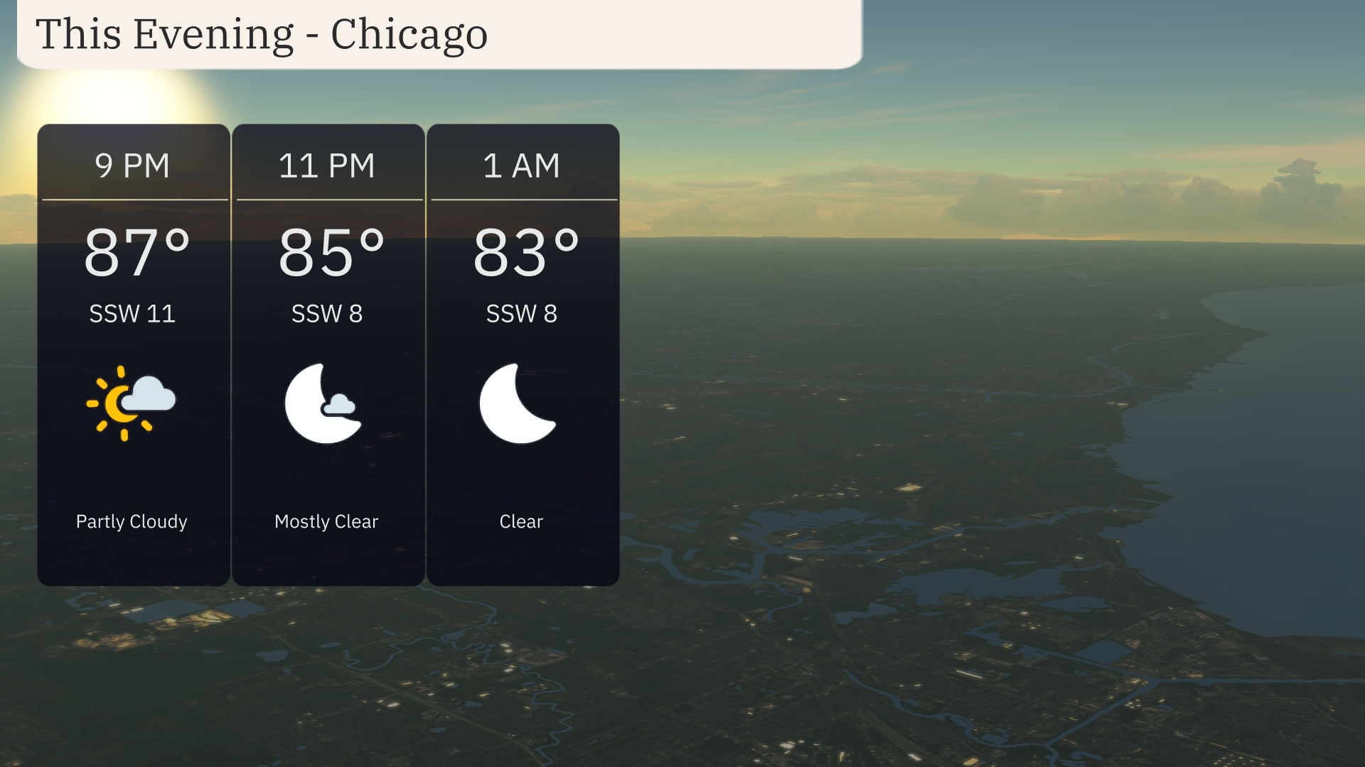
This evening in Chicago, expect partly cloudy skies at 9 PM with temperatures around 87 degrees. Winds will be from the south-southwest at 11 miles per hour. By 11 PM, conditions become mostly clear as temperatures dip to 85 degrees with calmer winds at 8 miles per hour. Clear skies will continue at 1 AM as temperatures slightly drop further to 83 degrees.
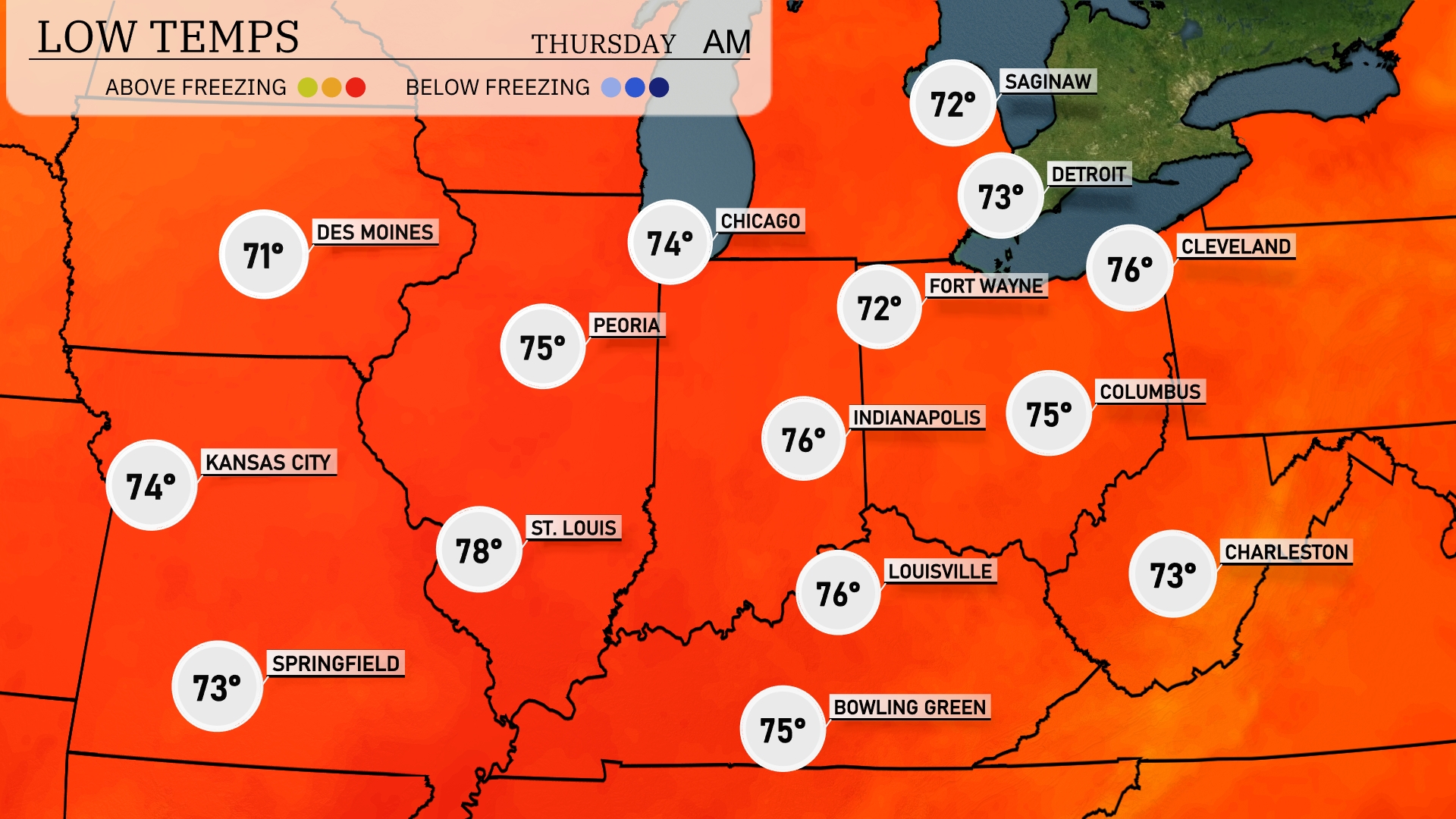
Tonight, Kansas City will see a low of 74 degrees, while Des Moines cools down to 71. Expect 75 degrees in Indianapolis and 76 in Louisville. Cleveland will drop to 76 degrees, and Chicago will have a comfortable low of 74.
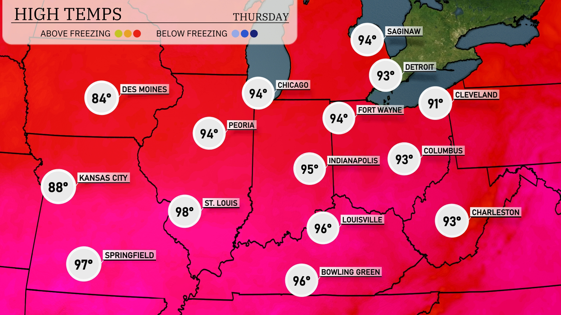
Tomorrow, we’re looking at sizzling temperatures across the Midwest. Chicago and Peoria will both hit a high of 94 degrees, while Indianapolis is slightly warmer at 95. St. Louis is forecasted to soar to 98, marking it as one of the hottest spots in the region. Kansas City will also feel the heat, reaching up to 88 degrees. Expect a mix of sunshine and humidity, driving these readings well above seasonal averages.
A dynamic weather shift is on the horizon for the Midwest. Expect a cold front sweeping through by late Wednesday, sparking storms from Kansas City to Chicago. These storms bring potential for heavy rain and gusty winds, especially impacting areas near Fort Wayne and Indianapolis during evening hours. Higher rainfall rates may lead to localized flooding concerns. Post-front, cooler and drier conditions move in by Thursday, offering a respite from the stormy weather.
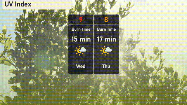
Expect the UV index in Chicago to be very high on Wednesday with a value of 9, posing a risk of sunburn in about 15 minutes if you’re in direct sunlight. By Thursday, the UV index slightly decreases to 8, with a burn time of 17 minutes, so remember to lather up on sunscreen and seek shade frequently!
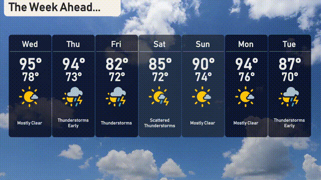
For the 7-day forecast in Chicago:
Wednesday: Expect mostly clear skies with a high of 95 degrees, dipping to 78 degrees at night.
Thursday: Thunderstorms are predicted early with a high reaching 94 degrees and a low of 73 degrees.
Friday: Look out for thunderstorms throughout the day, with temperatures peaking at 82 degrees and a low of 72 degrees.
Saturday: Scattered thunderstorms with afternoon temperatures around 85 degrees, cooling to 72 degrees overnight.
Sunday: Mostly clear skies return, as temperatures soar to 90 degrees during the day and 74 degrees at night.
Monday: Enjoy more clear weather with daytime highs of 94 degrees and nighttime lows of 76 degrees.
Tuesday: Thunderstorms are expected again, with a daytime high of 87 degrees and a low of 70 degrees.
Hope that helps, and stay weather-ready!