Heat Waves and Thunder Rolls: Navigating Chicago’s Dynamic Summer Weather
By
Amy Freeze
Experience the fluctuating climates of Chicago, from sweltering heat to thunderous skies. Get insights on navigating this fascinating weather pattern.
Get ready for a wild weather day in the Midwest! From sunny highs to stormy lows, see what’s brewing over Chicago and surrounding areas.
Join us as we delve into the ever-changing climate of the Midwest on June 17, 2025. Discover how temperatures soar and storms threaten to reshape the day. From Chicago’s peak temperatures reaching the late 80s to showers and thunderstorms creating dramatic scenes, our detailed forecast has everything covered to help you prepare and enjoy your day effectively. Plus, learn how to stay safe under the high UV index this summer!
The Midwest is experiencing dynamic weather conditions on the radar today. Heavy rain showers are sweeping through Indianapolis, extending toward Fort Wayne and moving eastward toward Columbus. Kansas City can expect some incoming rain from the west, while St. Louis remains mostly clear for now, with some clouds building nearby. Meanwhile, light patches of rain are seen developing around Bowling Green, moving toward Louisville, as a storm system begins to form in the region.
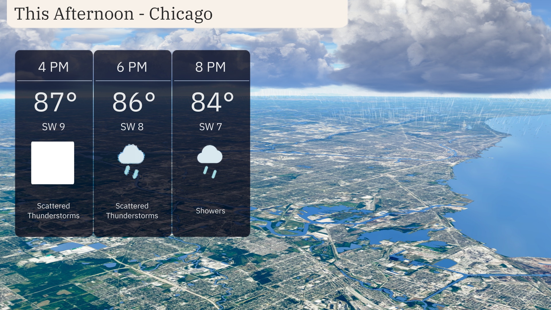
Afternoon in Chicago will see temperatures peaking at 87 degrees around 4 PM, with southwesterly winds at 9 miles per hour. Scattered thunderstorms are expected as temperatures slightly dip to 86 degrees by 6 PM. The evening continues with a drop to 84 degrees and showers likely at 8 PM as winds ease to 7 miles per hour.
Today’s high temperatures in the Midwest are impressively warm. In Chicago, expect a high of 89 degrees, while Peoria will also reach 89. St. Louis is heating up to 90, making it one of the hottest spots today. Indianapolis will see a high of 82 degrees, providing a slight contrast to the surrounding areas. Meanwhile, Fort Wayne is forecasted to hit 85 degrees, rounding out a warm day for the region.
Tonight, temperatures across the Midwest will dip significantly, with Chicago hitting a low of 64 degrees. Indianapolis is expected to cool down to 67 degrees, while St. Louis will see a minimum of 68 degrees. Expect a slightly warmer night in Louisville, where temperatures will settle around 70 degrees, and further south in Bowling Green, it will be 72 degrees.
Tomorrow in the Midwest, expect warm temperatures across the region with highs reaching 88 degrees in Louisville. Indianapolis will see a high of 86 degrees, while Columbus warms up to 84 degrees. St. Louis is looking at 85 degrees, and Kansas City will be slightly cooler at 82 degrees. Most areas are experiencing above-average temperatures, thanks to a high-pressure system positioning itself over the region, keeping the skies clear and allowing for warmer air to flow in. Chicago will also enjoy 79 degrees, marking a comfortable afternoon for the Windy City.
A strong line of thunderstorms will stretch from Des Moines to Chicago, bringing heavy rain and gusty winds. These storms are expected to move eastward through the day, impacting areas such as Fort Wayne and Indianapolis by late afternoon. Flooding rains may occur in some localized areas north of Indianapolis. In the evening, a cold front will arrive, causing temperatures to drop across the Midwest, providing relief from the recent warm spell. Despite the rain, high temperatures in the 80s will persist until the front passes.
In Chicago, the UV index will be high at 8 on Tuesday, with sunburn possible in about 17 minutes. On Wednesday, a moderate UV index of 6 suggests a burn time of around 23 minutes. Be sun-smart by wearing sunscreen and seeking shade, especially during midday.