Chicago’s Weather Ballet: Graceful Mornings and Stormy Nights
By
Amy Freeze
Unwind the curtain of clouds with Amy Freeze as we explore how a mix of sun and storms paints the Midwest's weather canvas. From serene beginnings to gusty evenings, every detail matters in the heartland's atmospheric dance.
Meteorologist Amy Freeze forecasts a mix of sun and clouds for Chicago, with storms intensifying towards evening. Dive into detailed updates and stay prepared!
From partly cloudy mornings to storm-laced evenings, Chicago’s weather is as dynamic as the city itself. Join Amy Freeze as she provides expert meteorological insights into the fluctuating conditions expected across the Midwest. Whether it’s the serene skies over Charleston or the storm alerts for Detroit, each provides a unique thread in our climatic fabric. Prepare and stay informed with detailed forecasts and safety tips tailored for every condition the weather brings.
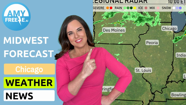
In the Midwest, our regional radar reveals a dynamic weather picture. A strong line of storms is marching across Illinois, sweeping from west to east with notable intensity from Peoria towards Chicago. These storms are expected to bring heavy rain and gusty winds as they continue their eastward journey.
Farther east, the scene shifts to the Great Lakes region where Detroit and Cleveland are experiencing powerful storms with a mix of rain, ice, and even snow, generating challenging conditions. These areas should prepare for varying precipitation types as the system pushes through.
Meanwhile, as we look towards the Ohio Valley, Fort Wayne and Columbus are dealing with significant rainfall, creating slick roads and reduced visibility. Indianapolis and Louisville are also seeing rain, with showers stretching down into Bowling Green, maintaining a wet and soggy day across these locations.
On a brighter note, farther south in Charleston, skies remain mostly dry and clear, offering a welcome contrast to the more turbulent weather to the north. As the weather system progresses, keep an eye on conditions, especially in areas currently under severe weather alerts, to ensure safety and preparedness.
Tomorrow morning in Chicago starts off mostly sunny, with temperatures around 48 degrees at 7 AM. As the morning progresses, expect temperatures to reach 49 degrees by 9 AM with a southwest wind at 15 miles per hour. By 11 AM, the clouds increase, leading to mostly cloudy skies with temperatures rising to 51 degrees.
Tomorrow, the Midwest region will see a range of high temperatures, continuing a trend of slightly above-average readings for early April.
In Chicago, expect a high of 56 degrees, while Peoria will reach 58 degrees. St. Louis is slightly warmer, with a high of 57 degrees. Indianapolis anticipates a comfortable 64 degrees, and just south in Louisville, temperatures rise to 66 degrees.
Heading east, Columbus could hit a high of 69 degrees, while Cleveland is forecasted to reach 66 degrees. The warmest spot will be Charleston, West Virginia, soaring to 75 degrees.
Expect a robust line of storms to make their way through the Midwest, spanning from St. Louis to Cleveland, with heavy rain and potential for damaging winds tomorrow. This active weather pattern is aligned with a cold front that will advance eastward, bringing thunderstorms from Indianapolis to Detroit into Wednesday evening. A heightened risk for isolated severe storms is present, so stay vigilant for any weather alerts in these areas. As the front progresses, areas like Fort Wayne can anticipate rainfall accumulations that may lead to localized flooding. In the wake of this system, temperatures are expected to drop slightly, offering a more mild atmosphere by the weekend.
The UV index in Chicago is low on Wednesday with a value of 2, largely due to cloud cover and storm activity reducing sun exposure. By Thursday, it edges up to a moderate 4, with a burn time of about 35 minutes in direct sunlight.
For the 7-day outlook in Chicago:
Thursday: Clouds early with clearing later on, expect a high of 56 degrees and a low of 40.
Friday: Mostly cloudy skies, with temperatures reaching a high of 49 degrees and a low of 41.
Saturday: Rain moves in, bringing a chill with a high of 47 degrees and a low of 37.
Sunday: Overcast conditions will persist with a high near 48 degrees and a low of 35.
Monday: Partly cloudy skies with temperatures dipping to a brisk 39 degrees high and cooling down to 28 at night.
Tuesday: Enjoy partly cloudy skies with a daytime high of 44 degrees and a nighttime low of 33.
Wednesday: The sun peeks out more with partly cloudy weather, highs reaching 57 degrees and lows around 45.