Chicago’s Sizzling Summer: From Heatwaves to Thunderstorms
By
Amy Freeze
Explore the dynamic shifts in the Midwest weather, from today's scorching heat to potential storm warnings, and what that means for your week ahead.
Today in Chicago: scorching heat with a top of 95°F, but don’t put your umbrellas away yet—storms are on the horizon! Stay tuned for more updates.
This week, Chicago is a showcase of meteorological extremes. We’ve seen temperatures pushing the mid-90s, and now, a strong cold front is set to bring showers, thunderstorms, and a welcoming drop in the mercury. With potential severe weather warnings and safety tips included, our detailed forecast helps you prepare for every weather scenario the Midwest might throw your way. Check out our full report at https://amyfreeze.ai/
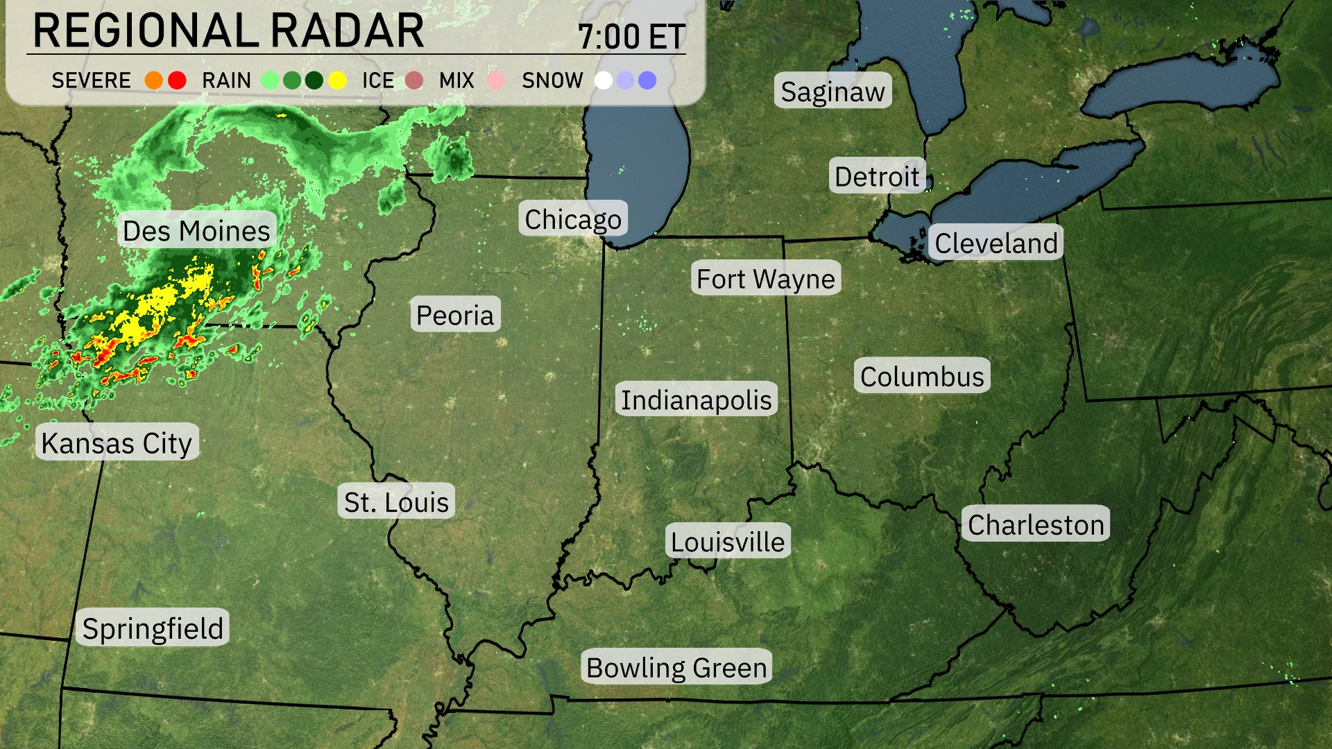
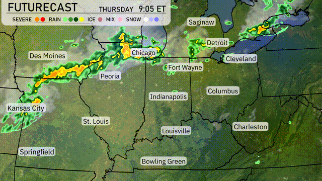
A line of rain showers is advancing across the Midwest, moving from Des Moines towards Peoria. Chicago and Springfield can expect increasing cloud cover as these showers approach. The rest of the region, including Kansas City and Indianapolis, remains mostly clear, but clouds are starting to build. Meanwhile, areas like Fort Wayne and Louisville enjoy dry conditions under partly cloudy skies.
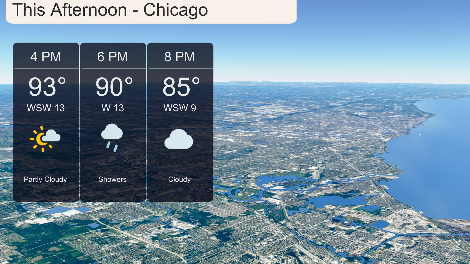
Afternoon temperatures in Chicago peak at 93 degrees, accompanied by a west-southwest wind of 13 miles per hour. Expect partly cloudy skies early in the afternoon, transitioning to showers by 6 PM as temperatures drop to 90 degrees. The evening will see temperatures decrease to 85 degrees with the wind shifting to the west-southwest at 9 miles per hour, under cloudy conditions.
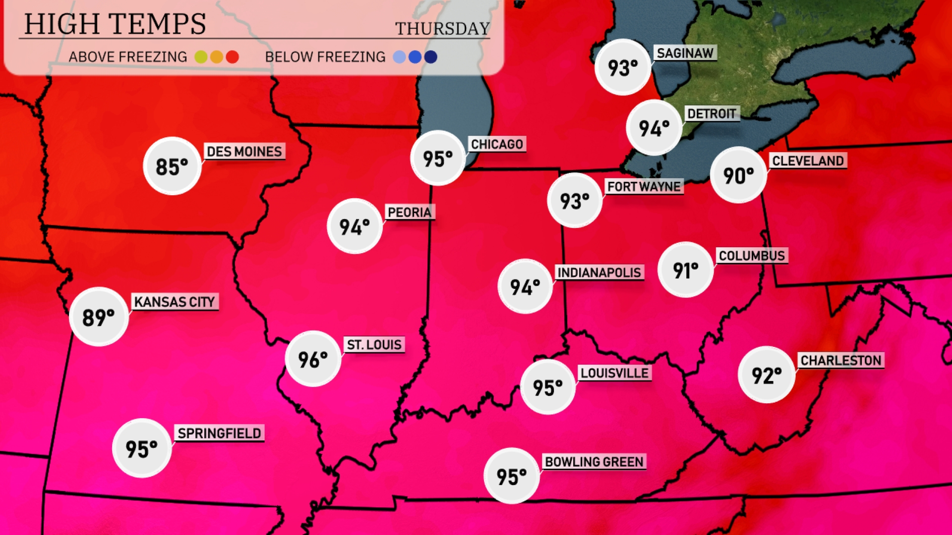
Today, the Midwest is heating up with some impressive high temperatures. Chicago is sweltering at 95 degrees, while Peoria follows closely behind at 94. To the south, St. Louis will hit 96 degrees, making it one of the warmest spots in the region. Meanwhile, Kansas City sits at a cooler 89 degrees, providing a bit of relief. In Indiana, Indianapolis will reach 94, while Fort Wayne isn’t far behind at 93 degrees, showcasing a classic summer day across the region.
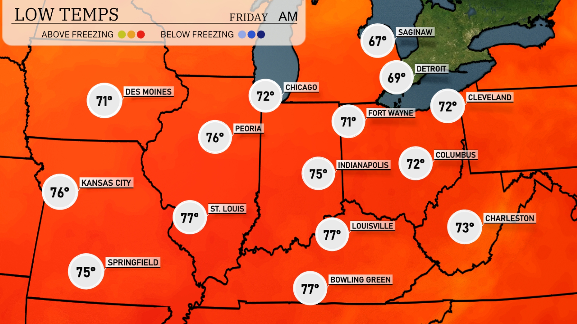
Tonight, lows will be mild across the Midwest with St. Louis dipping to 77 degrees and Indianapolis at 75. Kansas City won’t be far behind at 76, while Chicago sits at a comfortable 72. Expect similar temperatures in Cleveland and Columbus, both forecasted to reach 72 degrees overnight.
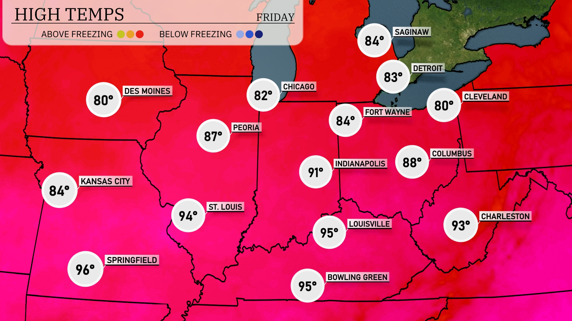
Tomorrow in the Midwest, St. Louis will see a high of 94 degrees, while Kansas City reaches 84. Indianapolis is expected to hit a warm 91 degrees, with Fort Wayne coming in slightly cooler at 84. Peoria will warm up to 87, and Louisville will reach a sweltering 95 degrees.
A strong cold front will sweep across the Midwest overnight, bringing a line of showers and thunderstorms from Kansas City to Cleveland. Expect heavy rain and potentially damaging winds, especially in areas stretching from Des Moines to Indianapolis. Storms could briefly intensify, causing localized flooding, with rainfall amounts surpassing an inch in some spots. By Thursday, the front progresses eastward, ushering in cooler and drier conditions from Chicago to Detroit. Keep an eye out for any Severe Thunderstorm Warnings as the front moves through.
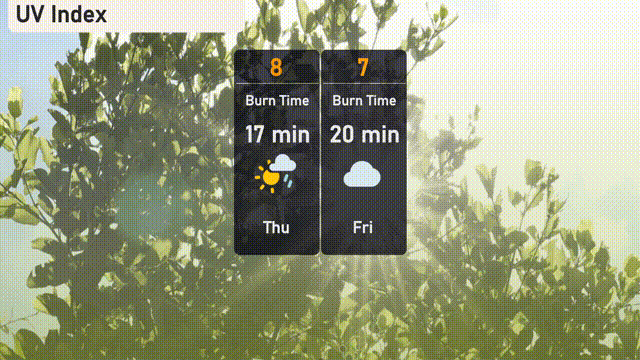
The UV index in Chicago will be high on Thursday, reaching a level of 8, with a burn time of around 17 minutes in direct sunlight. On Friday, the index decreases slightly to 7, with a burn time of about 20 minutes. Remember to apply sunscreen and seek shade when necessary!