From Thunderstorms to Sunshine: Chicago’s Dynamic Weather Week Ahead
By
Amy Freeze
Explore the unpredictable swings from severe thunderstorms to sunny skies in Chicago's weather forecast. Stay prepared with our detailed analysis and tips.
Chicago faces a weather rollercoaster this week with thunderstorms today and sunny skies to follow. Dive into our blog for a sneak peek into what to expect and how to prepare!
In this week’s update, we explore the volatile weather pattern over Chicago, from severe thunderstorms impacting the city tonight to pleasant sunny days that are set to break later this week. We cover each day’s predictions with precision and offer practical advice on navigating these shifts. For a full 7-day forecast and expert weather insights, follow the detailed discussions at our blog linked below. Stay weather-wise with us!
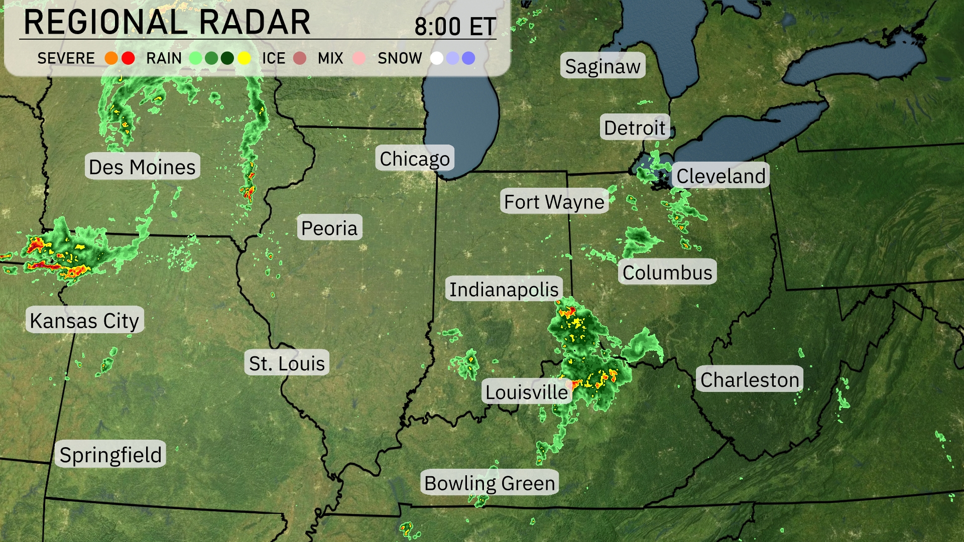
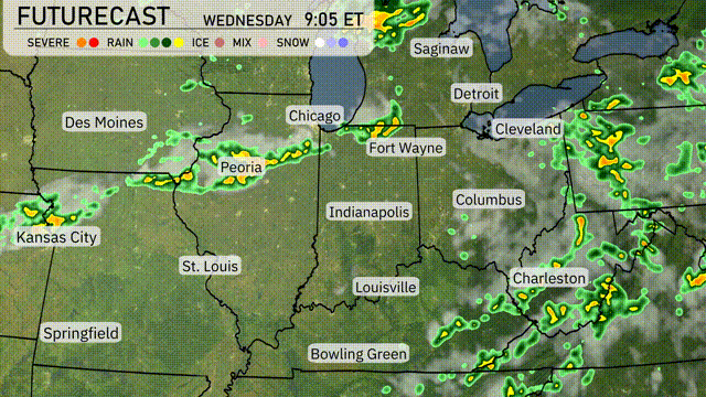
Severe storms are currently east of Kansas City, moving towards Springfield, creating a lively weather day across the Midwest. Indianapolis is experiencing widespread rain, which is now progressing towards Fort Wayne, with Louisville also seeing significant wet weather. Showers are stretching from Columbus down towards Charleston, indicating varied precipitation across these areas. Des Moines and St. Louis remain clear, offering a quieter weather scenario.
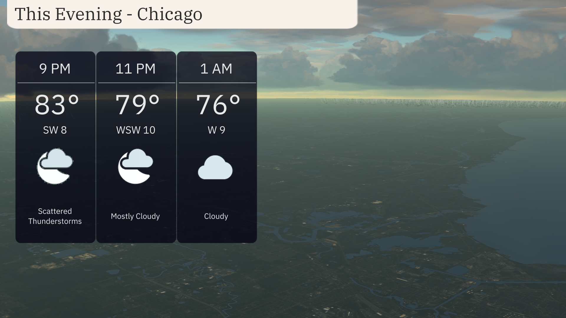
This evening in Chicago, temperatures will dip from 83 degrees at 9 PM to 76 degrees by 1 AM. Expect scattered thunderstorms at 9 PM, transitioning to mostly cloudy skies by 11 PM. Winds will shift from southwest at 8 mph to west-southwest at 10 mph, calming to 9 mph overnight.
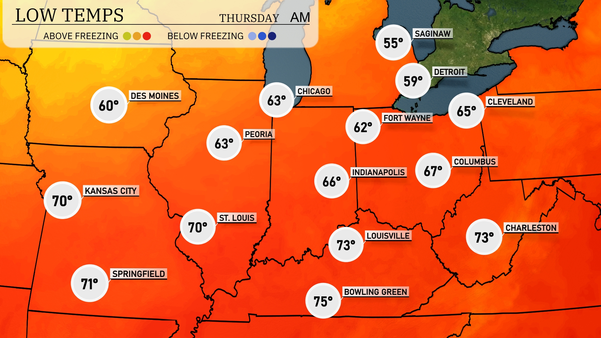
Tonight, Chicago will see a low of 63 degrees, while Des Moines dips to 60 degrees. Indianapolis is expected to cool down to 66, and Fort Wayne will drop to 62 degrees. Detroit will experience a cooler night at 59 degrees, with Saginaw falling to 55.
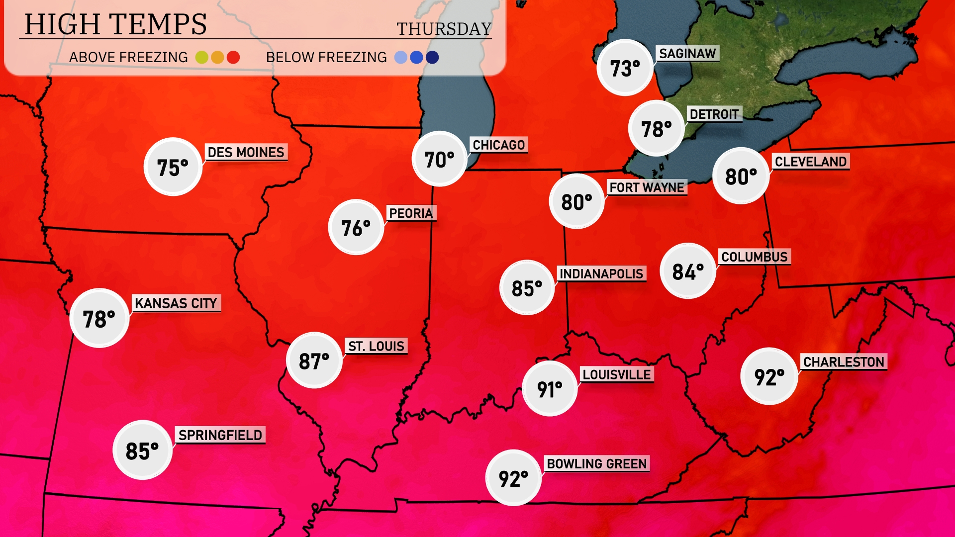
Tomorrow in St. Louis, expect a high of 87 degrees, while Kansas City will see a slightly cooler 78. Chicago will warm up to 70 degrees, but further south, Indianapolis is set to reach 85 degrees. Notably, Louisville is heading for a hot 91 degrees, with Bowling Green hitting 92.
A cold front pushes through the Midwest with thunderstorms bringing heavy rain and possible gusty winds across areas like Chicago and Peoria tonight. Expect showers to linger over Fort Wayne and Indianapolis tomorrow morning before skies begin to clear. Deeper into the Ohio Valley, cities like Louisville will see scattered rain showers, while Columbus takes on intermittent storms. Temperatures behind the front will drop slightly, offering cooler and more comfortable conditions by afternoon. For those in the northern Midwest, areas like Detroit and Saginaw should prepare for rain showers and the potential for localized flooding through the next 24 hours.
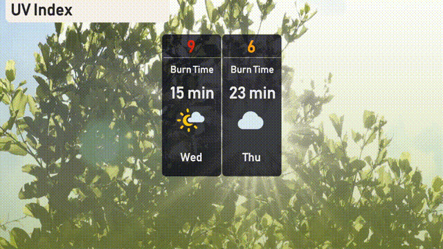
The UV index in Chicago is high today, peaking at 9, with a burn time of just 15 minutes, so make sure to apply sunscreen and seek shade. For tomorrow, there’s a decrease to a moderate level of 6, reducing the burn time to 23 minutes, thanks to some cloud cover.
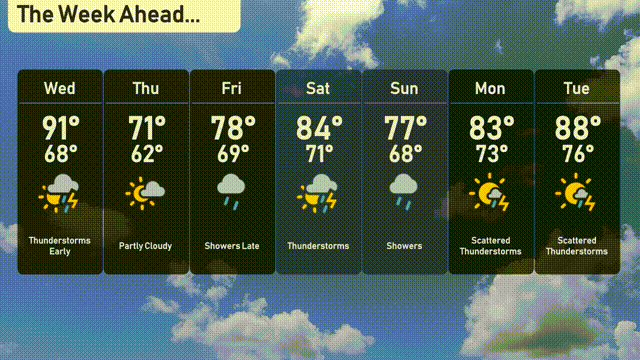
For the 7-day forecast in Chicago:
Wednesday: Thunderstorms in the early morning with temperatures reaching a high of 91 degrees and a low of 68 degrees.
Thursday: Partly cloudy skies with a high near 71 degrees, dipping down to 62 degrees at night.
Friday: Showers are expected to arrive late, with the temperature hitting a high of 78 degrees and a low of 69 degrees.
Saturday: Expect thunderstorms and warmer weather, as the high climbs to 84 degrees and the low stays at 71 degrees.
Sunday: Showers continue with a high of 77 degrees and a nighttime low of 68 degrees.
Monday: Scattered thunderstorms are likely to develop, with a high of 83 degrees and a low around 73 degrees.
Tuesday: Ending the week with thunderstorms and another warm day, with temperatures reaching a high of 88 degrees and a low of 76 degrees.