Swinging Temperatures: A Glimpse into Chicago’s Dynamic Weather Patterns
By
Amy Freeze
Experience the drastic temperature changes and stormy forecasts set to dominate Chicago's weather landscape. Stay ahead with our comprehensive guide.
Chicago sees a weather roller-coaster, from balmy highs to stormy lows. What does this mean for locals and visitors?
This week, Chicago’s weather takes us on a wild ride, from scorching highs reaching 91 degrees down to cooler storm-induced temperatures. With severe weather warnings in place, how should residents prepare? Find out all you need to know about facing these changing skies and staying safe during weather extremes.
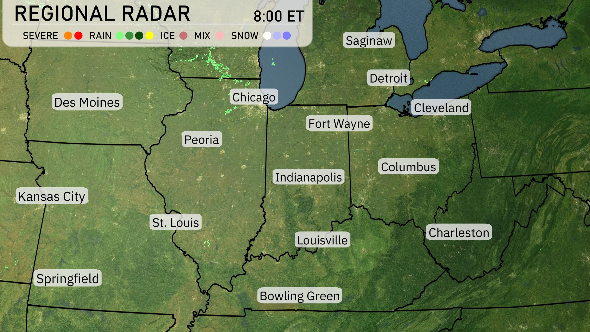
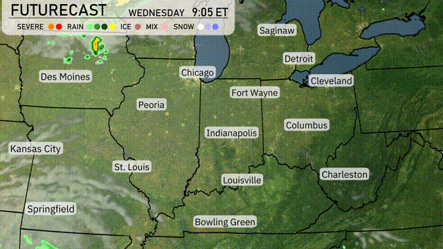
On the Regional Radar, Chicago is witnessing some severe weather activity, with storms moving in from the northwest. Scattered showers are impacting areas around Peoria, while rain is also detected near Springfield. Fort Wayne and Indianapolis are observing a mix of rain and ice, indicating potentially slippery conditions. Elsewhere, cities like Des Moines and Cleveland remain under clear skies.
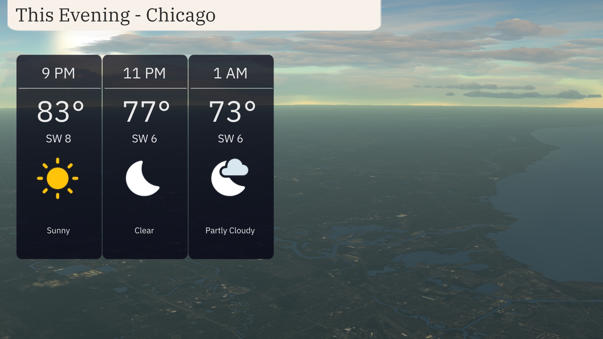
For this evening in Chicago, temperatures will start at 83 degrees at 9 PM with clear skies and a light southwest wind at 8 mph. By 11 PM, the temperature will drop to 77 degrees, accompanied by continued clear conditions and a gentle southwest breeze at 6 mph. As we move into the early morning hours at 1 AM, expect partly cloudy skies with temperatures around 73 degrees and light winds from the southwest.
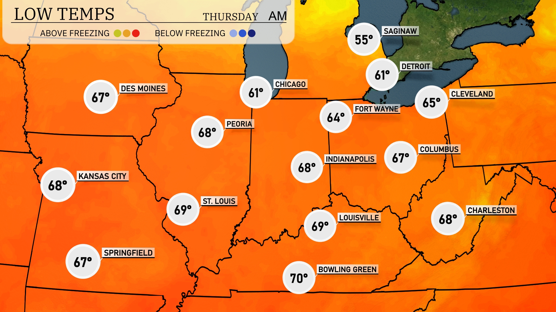
Tonight, Chicago will cool down to 61 degrees, while Fort Wayne dips to 64. Indianapolis is expected to see a low of 68. In contrast, temperatures in cities like Kansas City and Springfield will remain warmer at 68 and 67 degrees respectively.
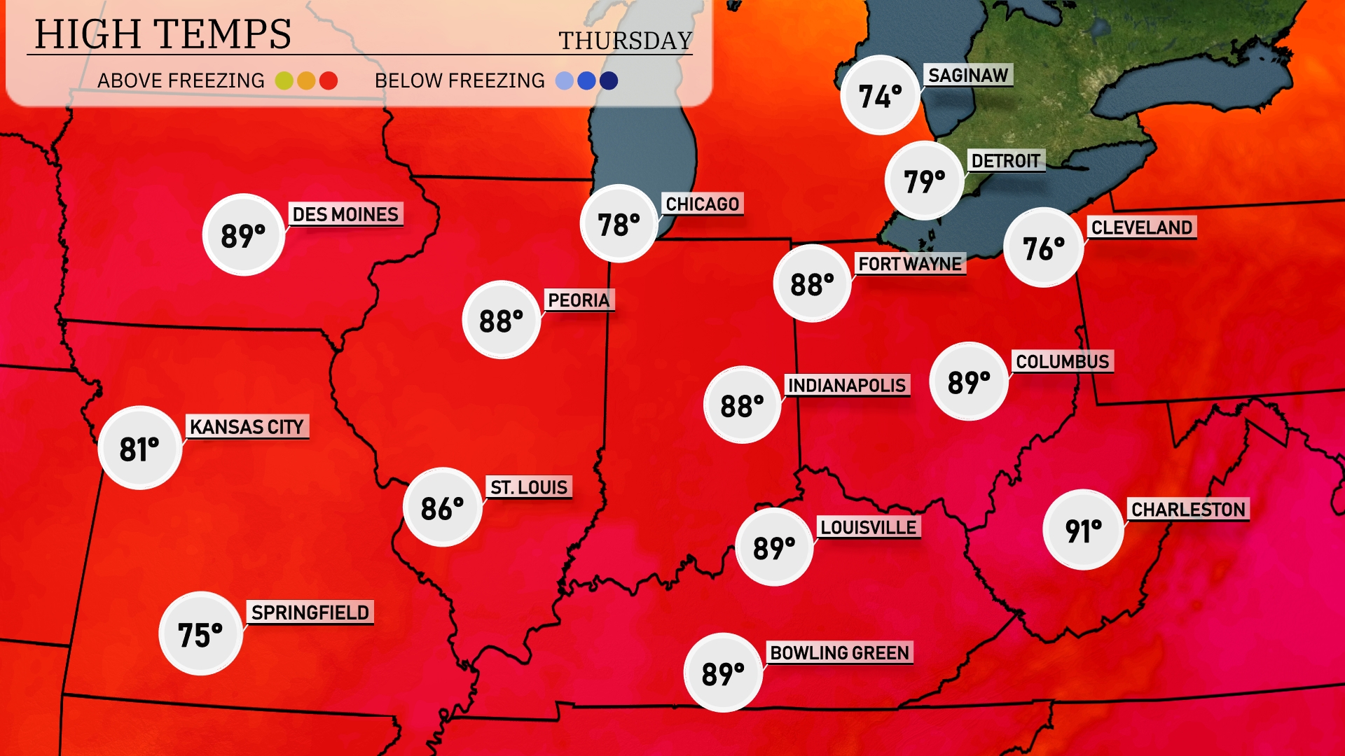
Tomorrow, high temperatures in the Midwest will soar, with Indianapolis and Louisville both reaching a warm 89 degrees. Chicago will see a pleasant high of 78, while Kansas City will warm up to 81. Temperatures are well above average for this time of year, with highs peaking at 91 in Charleston
A cold front is set to move across the Midwest, bringing scattered thunderstorms from Des Moines to Indianapolis by late Wednesday afternoon. Expect heavy rains and potential flash flooding in low-lying areas, particularly around St. Louis. Temperatures will dip a few degrees cooler following the front, offering some relief from the recent warmth. Be cautious of strong winds accompanying storms, which could lead to minor power outages. As the system moves east, expect clearing skies over Cleveland and Detroit into Thursday, along with a brief period of gusty winds.
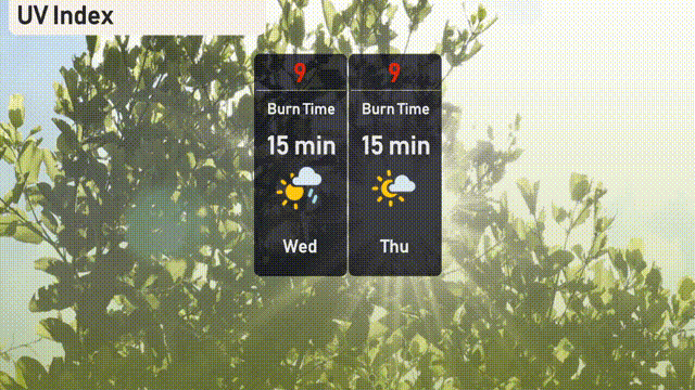
The UV index in Chicago is expected to be very high at 9 on both Wednesday and Thursday, with a burn time of just 15 minutes in direct sunlight.
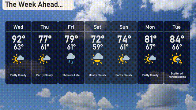
For the 7-day Chicago forecast:
Wednesday: We’re looking at partly cloudy skies with a high of 92 degrees and a low of 63 degrees.
Thursday: Temperatures will cool down to 77 degrees for a high, dropping to 61 degrees at night with partly cloudy conditions.
Friday: Showers are expected to arrive late in the day with the temperature reaching 79 degrees and the low remaining at 61 degrees.
Saturday: The day will be mostly cloudy, with cooler temperatures reaching a high of 72 degrees and a low of 59 degrees.
Sunday: Partly cloudy skies accompany a slight warming, with highs of 74 degrees and lows around 61 degrees.
Monday: Expect partly cloudy skies and a comfortable high of 81 degrees, with temperatures dipping to 67 degrees overnight.
Tuesday: Scattered thunderstorms are likely, as temperatures rise to a high of 84 degrees, with a low of 66 degrees.