Navigating the Climate Carousel: Chicago’s Dynamic Weather Forecast
By
Amy Freeze
From sunny afternoons to stormy evenings, meteorologist Amy Freeze provides an in-depth look at the ever-changing weather patterns over Chicago and the Midwest. Dive into detailed forecasts, temperature variations, and upcoming weather alerts.
Catch the latest on Chicago’s weather as Amy Freeze, renowned meteorologist, shares insights into this week’s climate dynamics, from warm bursts to chilling snowfalls.
In this detailed post, Amy Freeze takes us through a meteorological journey across Chicago and the Midwest. She discusses the varying weather conditions from clear skies in Kansas City to snow showers in Detroit, provides weather predictions for the upcoming days including potential severe weather alerts, and the expected impact of a strong low-pressure system moving through the area. Get ready for a week of weather swings with insights on temperature highs and lows, ensuring you stay prepared.
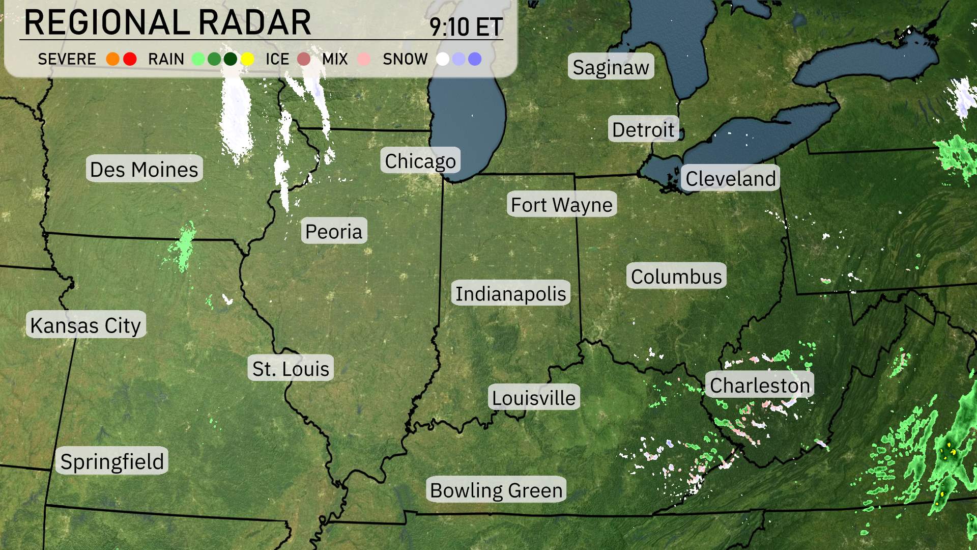
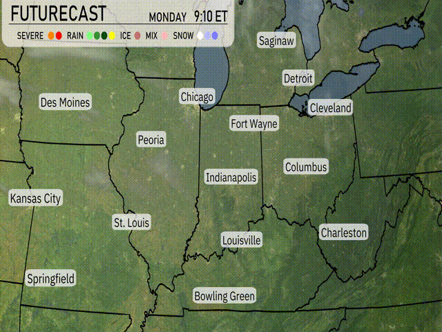
Over the Midwest, the regional radar indicates clear skies for areas such as Kansas City, Des Moines, and Springfield, providing a break from any precipitation. In contrast, a mix of rain and snow is observed in Chicago’s vicinity, creating a potential for slick roads as precipitation continues. Snow is dominating the scene from Des Moines through Fort Wayne, moving eastward. Heading east, Saginaw and Detroit are experiencing light snow showers. Cloud cover is prevalent over Cleveland, with some scattered snow showers in the vicinity. Columbus has overcast conditions, with the potential for intermittent snow flurries. The radar shows clear skies over Bowling Green and Nashville, allowing for a crisp and dry day. Over to the east, Charleston is witnessing scattered rain showers, with areas around experiencing light precipitation, signaling a wet start to the day for some.
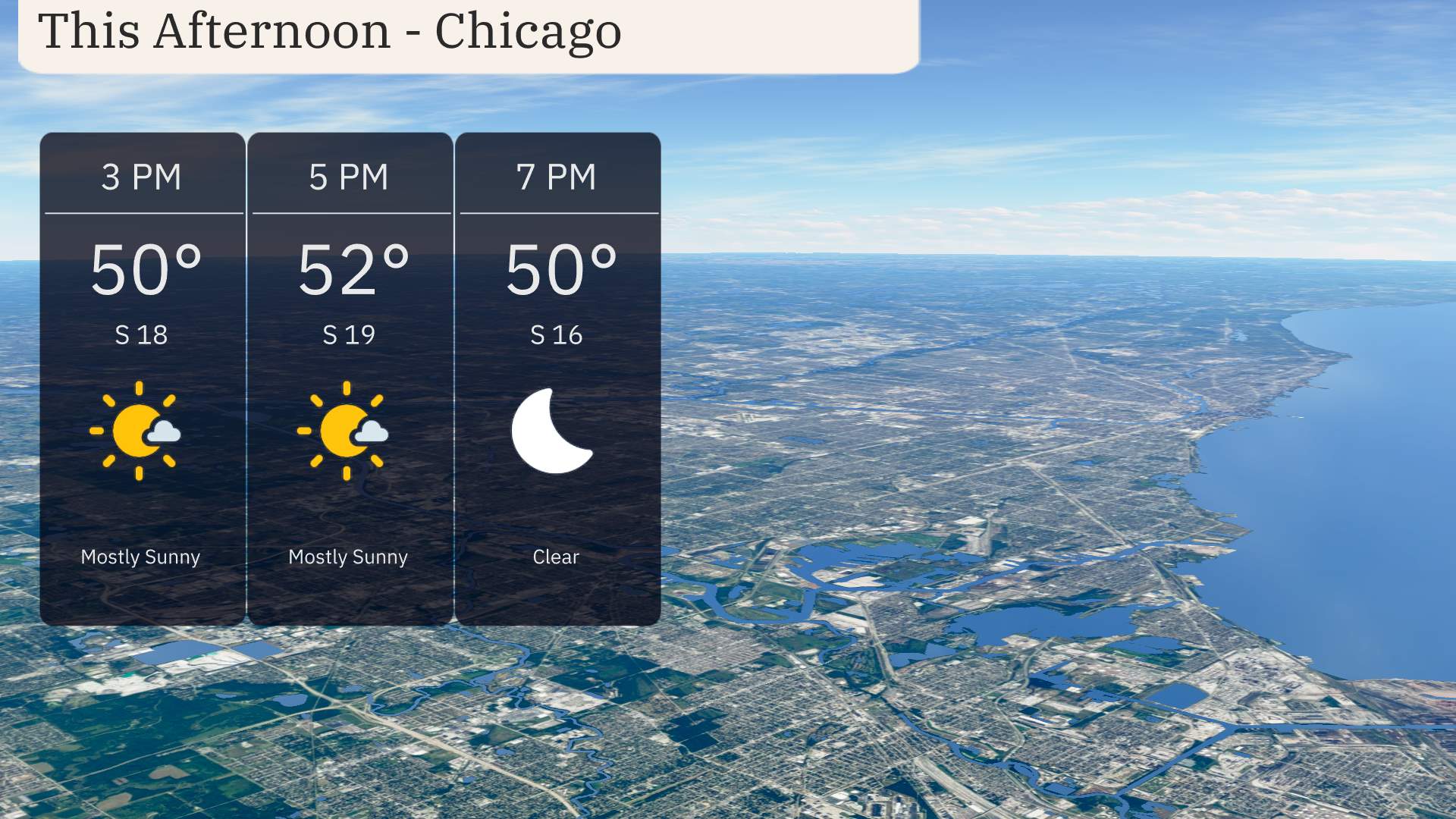
Chicago will experience a breezy afternoon with mostly sunny skies. Temperatures are expected to reach a high of 52 degrees by 5 PM. Winds will be coming from the south at around 18 to 19 miles per hour throughout the afternoon. By 7 PM, the temperature will ease back to 50 degrees under clear skies.
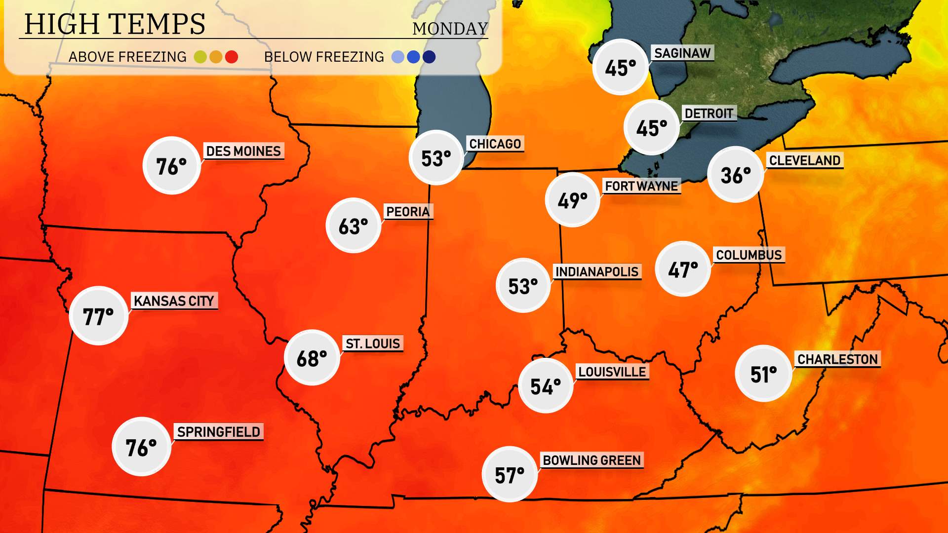
Let’s take a look at the high temperatures across the Midwest today. In Kansas City, it’s a beautiful day with a high reaching 77 degrees, giving residents a taste of early spring. Just to the north, Springfield is also warming up nicely with a high of 76 degrees.
Moving east, Peoria enjoys a pleasant 63 degrees, while in Indiana, Indianapolis lags slightly behind at 53. Heading farther north, Chicago is a bit cooler than its neighbors with a high of only 53 degrees.
The temperatures drop even further in Ohio, where Columbus is only reaching 47 degrees, and Fort Wayne is barely warmer at 49. Cleveland continues to feel the chill with a high of just 36 degrees.
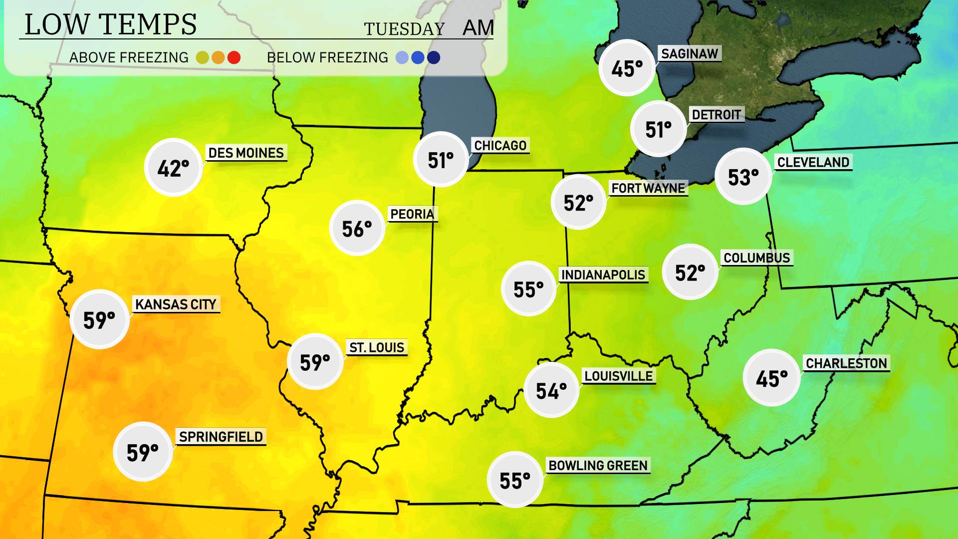
Now for the low temperatures in the Midwest, Chicago will cool down to 42 degrees, with Fort Wayne dropping to 52. Indianapolis is forecasted at 55 degrees, while Peoria will see a low of 56. In St. Louis, temperatures will dip to 59 degrees. Meanwhile, Kansas City will remain a bit warmer at 59 as well.
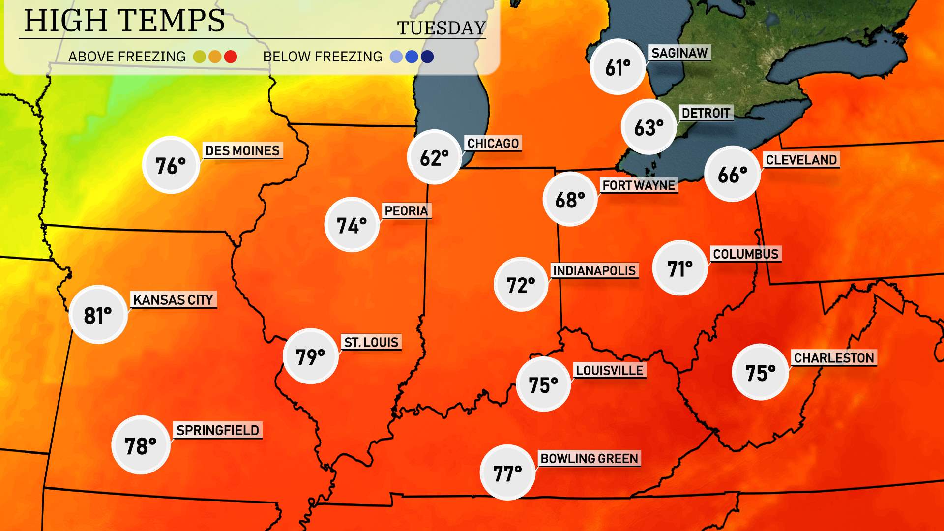
High temperatures across the Midwest tomorrow are expected to be quite warm for this time of year. Kansas City leads the pack with a high of 81 degrees, a noticeable above-average reading. St. Louis will also be warm at 79 degrees, while Springfield follows closely at 78 degrees.
To the north, Peoria sees a high of 74 degrees, with Indianapolis reaching 72 degrees. In contrast, Chicago will remain cooler at 62 degrees, as it feels the influence of some lingering clouds and potential rain.
Farther east, Louisville will enjoy a high of 75 degrees, while in Columbus, temperatures will reach 71 degrees. Overall, a warm air mass is moving through the region, bringing these above-normal temperatures, especially in the southern areas.
“After the warmth builds today, a change is in store for late tomorrow. A strong low-pressure system will move through the Midwest over the next 24 hours. Expect widespread rain, with the heaviest downpours in Chicago and Indianapolis by late afternoon. Thunderstorms are likely, particularly around Detroit, posing a risk for localized flooding. As the system progresses eastward, temperatures will drop by about 10 degrees, bringing a chance of snow flurries in northern parts like Saginaw and Cleveland. Stay alert for any severe storm warnings issued by the Storm Prediction Center as the front approaches.”
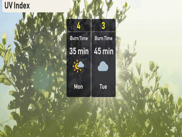
The UV index in Chicago will be moderate today, Monday, with a level of 4, leading to a burn time of about 35 minutes in direct sunlight. On Tuesday, it decreases to a low of 3 due to increased cloud coverage, reducing the risk and potential burn time significantly.