Chicago’s Weather Rollercoaster: Navigating a Week of Dynamic Changes
By
Amy Freeze
From thunderstorms to clear skies, Chicago’s weather is taking us on a wild ride this week. Get the full forecast, tips on handling high UV levels, and what to expect night by night.
Get ready, Chicago! A week of varied weather awaits. From rain and thunderstorms to bright sunny days, know what’s coming with daily insights and safety tips.
This week in Chicago, weather dynamics are spinning a tale of thunderstorms, heavy rains, and sunny breaks. With daily temperatures fluctuating and UV levels peaking, it’s crucial to stay prepared. Our extensive guide covers each day’s forecast, practical weather handling tips, including UV safety measures, and what each change means for you. Navigating this week’s weather in Chicago? We’ve got you covered with day-by-day breakdowns and expert advice.
A wave of showers is traversing the Midwest, with rain currently extending from Des Moines to Indianapolis. Areas like Columbus and Fort Wayne are seeing considerable cloud cover as the rain moves through. In Kansas City and St. Louis, expect breakouts of rain showers throughout the day, especially in the afternoon. Meanwhile, a wedge of showers stretching from Bowling Green to Louisville marks the path of advancing clouds, bringing precipitation to the region.
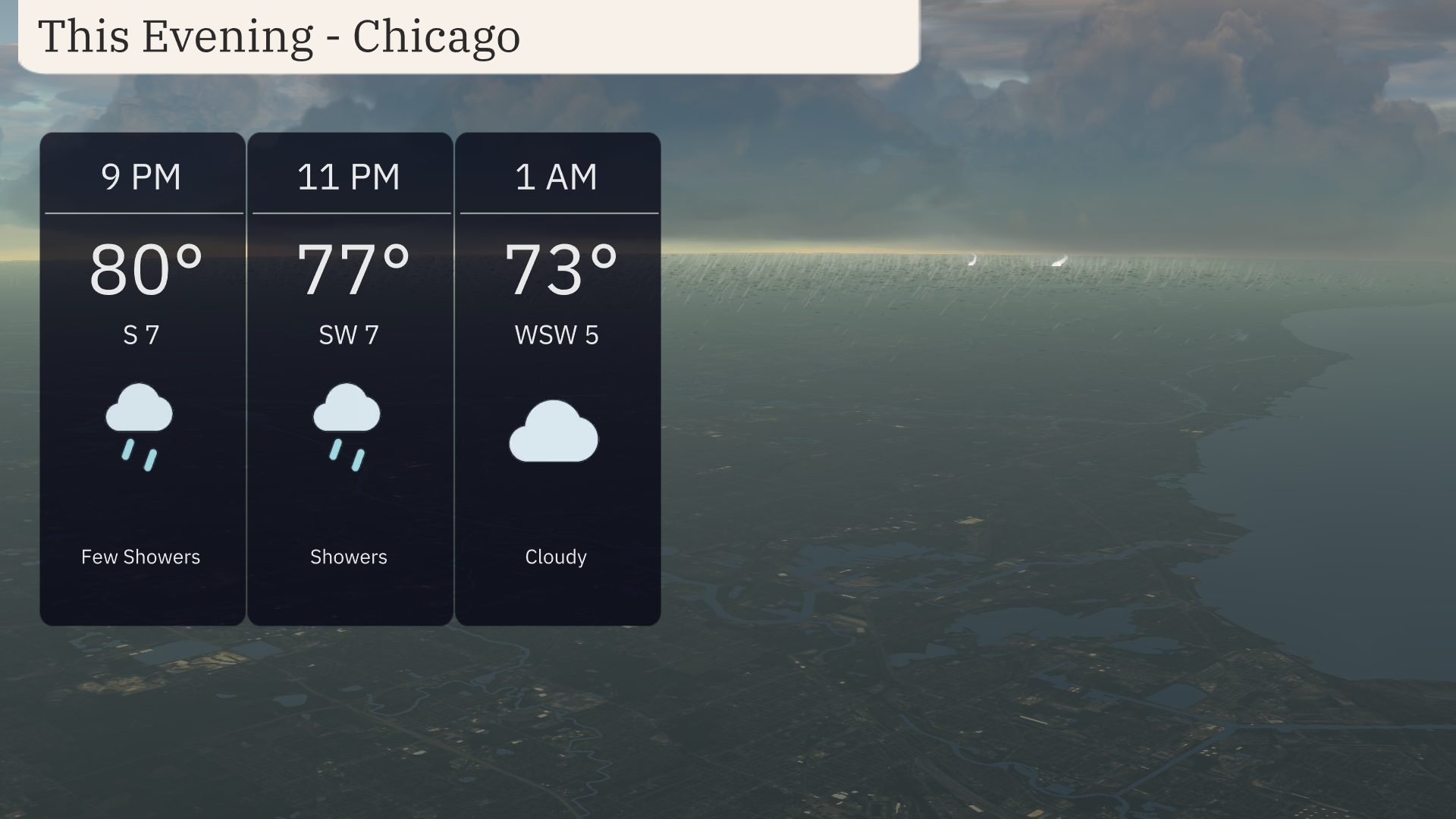
For the evening in Chicago, temperatures will start at 80 degrees at 9 PM, dipping to 77 degrees by 11 PM with showers expected. Winds will transition from south at 7 mph to southwest, maintaining 7 mph through the evening. By 1 AM, temperatures will settle at 73 degrees under cloudy skies, with winds shifting to west-southwest at 5 mph. Keep an umbrella handy for those intermittent showers earlier in the evening.
Tonight, temperatures will dip to around 61 degrees in Des Moines and 64 degrees in Chicago. Kansas City is expected to see a low of 67, while Indianapolis will maintain a similar temperature of 67 degrees as well. Further south, Louisville will stay warmer at 70 degrees, while St. Louis cools just slightly to 68 degrees. The trend shows a relatively mild night across the Midwest, with no significant drops into colder air expected.
Tomorrow in the Midwest, high temperatures are reaching impressive levels with Louisville soaring to 88 degrees. Indianapolis is not far behind, expecting a warm high of 86 degrees. Kansas City will experience a comfortable 82 degrees, while St. Louis is set to reach 85 degrees. Chicago should see a high of 79 degrees, and Detroit is also expected to enjoy a pleasant day with a high of 82 degrees. Overall, temperatures are well above average for this time of year, influenced by a warm air mass moving into the region.
A frontal system is moving through the Midwest, bringing showers and thunderstorms to areas including Chicago, Peoria, and Fort Wayne. Expect periods of heavy rain, with an inch or more possible, which could lead to localized flooding in low-lying areas. The storms may also bring gusty winds, so take caution and secure loose outdoor items. Temperatures will begin to drop behind the front, providing cooler conditions that will persist through midweek. Keep an eye on the forecast for any changes in storm severity as the system progresses.
The UV index in Chicago will be high on Tuesday and Wednesday, both days reaching a level of 7. Expect sun exposure to result in a burn time of around 20 minutes, so wearing sunscreen and protective clothing is important. Keep an eye on the sky as storm clouds could occasionally mitigate UV levels.
For the 7-day forecast in Chicago:
Tuesday: Scattered thunderstorms expected with a high of 91 degrees and a low of 70 degrees.
Wednesday: Partly cloudy skies, cooling down to a high of 78 degrees and a low of 63 degrees.
Thursday: Enjoy mostly clear weather with a high reaching 85 degrees, dipping to 68 degrees at night.
Friday: Mostly clear again as temperatures climb to 89 degrees with an overnight low of 74 degrees.
Saturday: Sunny skies dominate the day, with a high of 95 degrees and a low of 78 degrees.
Sunday: Clear and warm, peaking at 96 degrees during the day, cooling slightly to a low of 78 degrees.
Monday: Another clear day with a high of 96 degrees and a comfortable low of 75 degrees.
Hope that helps! Stay safe and enjoy the weather!