Thunder Rolls and Temperatures Soar: A Closer Look at Chicago’s Week in Weather
By
Amy Freeze
Explore a week of contrasts in Chicago’s weather, from incoming thunderstorms to serene sunny intervals. Your ultimate guide to navigating the Midwest’s unpredictable skies is here!
This week’s weather roundup for Chicago: Expect everything from scorching heatwaves to cooling thunderstorms. Stay updated and prepared with Amy Freeze’s exclusive forecasts!
As the Midwest braces for a week filled with meteorological mood swings, Chicago takes the spotlight with its series of weather transformations. From thunderstorms initiating temperatures rising to 92°F, to breaks of partly cloudy skies at a gentle 80°F, each day brings its own set of challenges and surprises. Discover how these weather patterns will impact your daily plans and learn tips for staying safe and maximizing your enjoyment outdoors through expert insights provided by Amy Freeze.
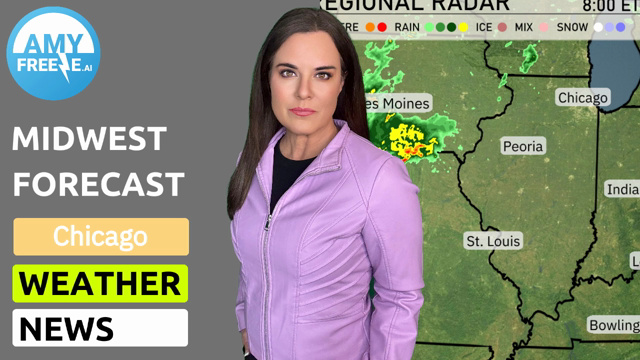
A line of rain showers is moving across western Iowa, heading towards Chicago, with Des Moines experiencing moderate rainfall. This line extends south into northern Missouri, where Kansas City is seeing the onset of rain and possible thunderstorms. St. Louis and Springfield remain dry under clearer skies. The eastern part of the Midwest near areas like Bowling Green and Louisville is still experiencing calm weather conditions ahead of these systems.
In Chicago, the afternoon brings scattered thunderstorms along with temperatures peaking at 87 degrees by 4 PM. Winds will be coming from the west at 8 miles per hour. Expect temperatures to cool slightly, dropping to 81 degrees by 6 PM as winds shift to the north-northeast at 7 miles per hour. By 8 PM, temperatures settle at 79 degrees with a north-east breeze at 6 miles per hour, maintaining the possibility of thunderstorms.
Today’s high temperatures across the Midwest are notably warm. In St. Louis, expect a hot day with a high of 96 degrees, while Kansas City and Springfield will align at a balmy 91. Moving eastward, Indianapolis will see a high of 93 degrees, and Louisville is nearly sizzling at 97. In contrast, Chicago’s temperature reaches 91 degrees, a bit milder compared to the southern cities. Charleston stands out with an eye-catching high of 98 degrees, making it one of the hottest spots in the region today.
Tonight, Chicago will see a low of 69 degrees, while Indianapolis cools down to 75. In Des Moines, temperatures will drop to 73, and Kansas City will settle at a mild 77. Expect Springfield to remain steady at 72 degrees, marking a relatively warm night across the Midwest.
Tomorrow in the Midwest, expect warm highs with Kansas City reaching 95 degrees. St. Louis is slightly warmer at 96, while Peoria will see a high of 91 degrees. Louisville and Bowling Green are set to soar to 96 and 97 degrees respectively, indicating above-average temperatures for this time of year. Indianapolis will experience a high of 92, contributing to the overall warm trend across the region. Cooler readings can be found in Chicago at 77 degrees, influenced by a front moving through.
A low-pressure system is moving across the Midwest tomorrow, bringing widespread showers and thunderstorms, especially from Kansas City through to Fort Wayne. Expect localized heavy rain that could lead to flash flooding in areas like Chicago and Indianapolis. Daytime highs will range from mid-70s in Des Moines to upper 60s in Cleveland due to cloud cover and rain. The intensity of storms could increase by evening, with a marked risk of hail and strong winds, primarily over northern Illinois. Keep an eye on alerts as this weather system tracks eastward, gradually clearing by mid-day Wednesday.
For Chicagoland, the UV index is 7 both today and tomorrow, indicating a high risk of harm from unprotected exposure to the sun with a burn time of about 20 minutes.