Navigating Through Chicago’s Skies: A Comprehensive Weekly Weather Guide
By
Amy Freeze
Explore Chicago’s 7-day weather forecast, from tranquil evenings to turbulent thunderstorms. Get the insight needed to plan your week effectively.
The coming week in Chicago looks varied with temperature changes and stormy skies. Prepare with our detailed weather insights!
This week, Chicago’s weather takes us on a rollercoaster ride of climatic fluctuations. From warm, sunny afternoons to unexpected thunderstorms, our comprehensive guide breaks down what to expect each day. On Tuesday, anticipate hot conditions with a high of 90 degrees but stay prepared for potential showers by Wednesday evening. The remainder of the week promises mixed weather, including cooler temperatures and thunderstorms by the weekend. For detailed forecasts and weather warnings, keep abreast with our updates to make your days in Chicago as unpredictable as its weather.
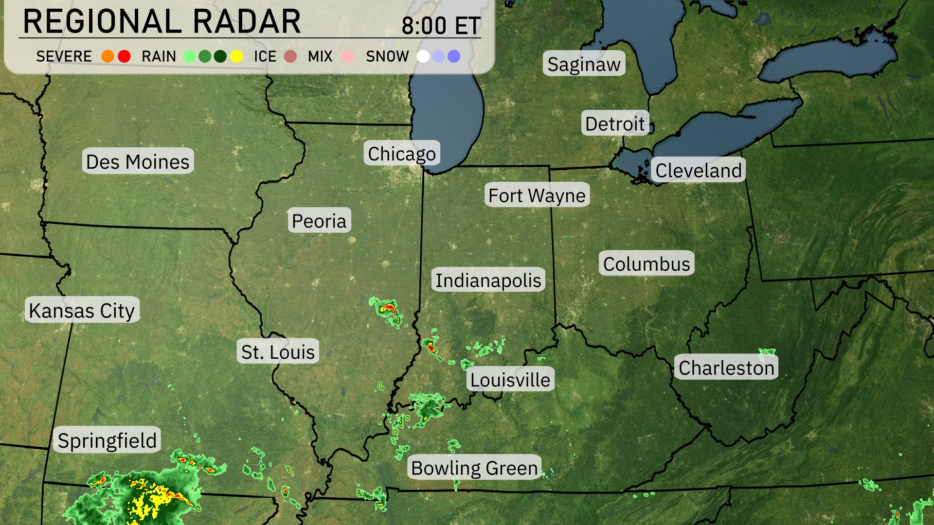
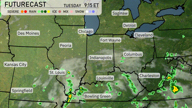
A line of showers is currently moving through central Illinois, extending from Springfield northeast towards Chicago, bringing moderate rain to these areas. Thunderstorms are developing just southeast of Springfield, potentially intensifying as they track eastward. Spotty rain showers are also popping up near Indianapolis and heading towards Fort Wayne. Des Moines to St. Louis enjoys clearer skies with minimal precipitation on the radar.
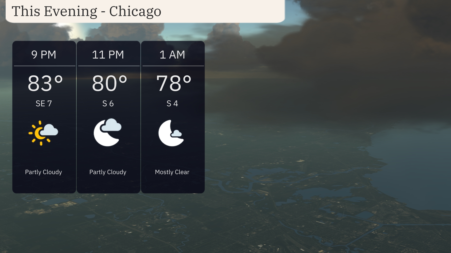
For this evening in Chicago, temperatures will gradually dip from 83 degrees at 9 PM to 78 degrees by 1 AM. Winds will shift from southeast at 7 miles per hour to south at 4 miles per hour as the evening progresses. Expect partly cloudy skies early, transitioning to mostly clear conditions after midnight.
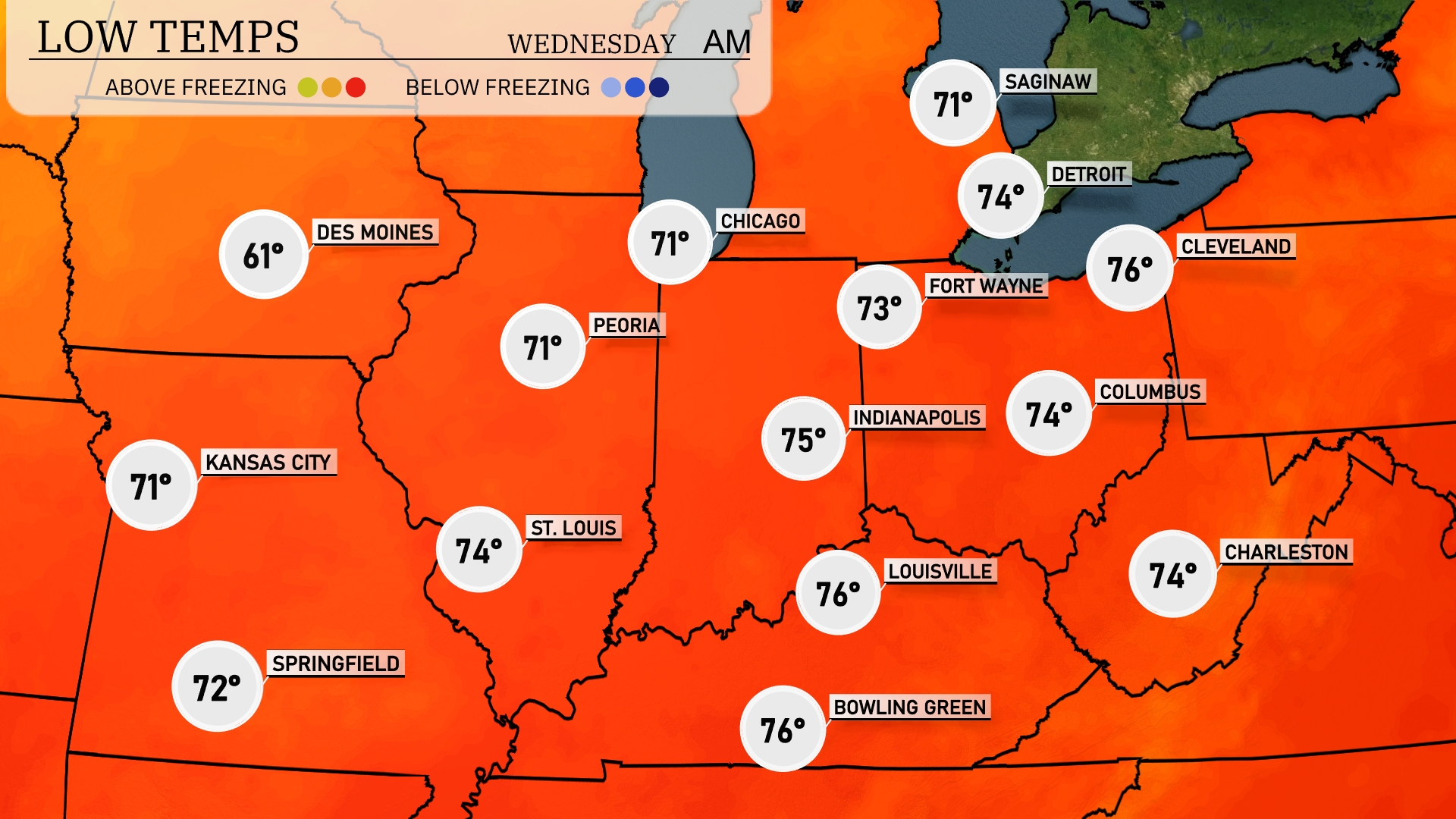
Tonight, low temperatures in the Midwest will hover around the low 60s in several areas. Des Moines will see a low of 61 degrees, while Chicago and Peoria will both drop to 71 degrees. Kansas City should be slightly warmer at 71 degrees, with St. Louis recording 74.
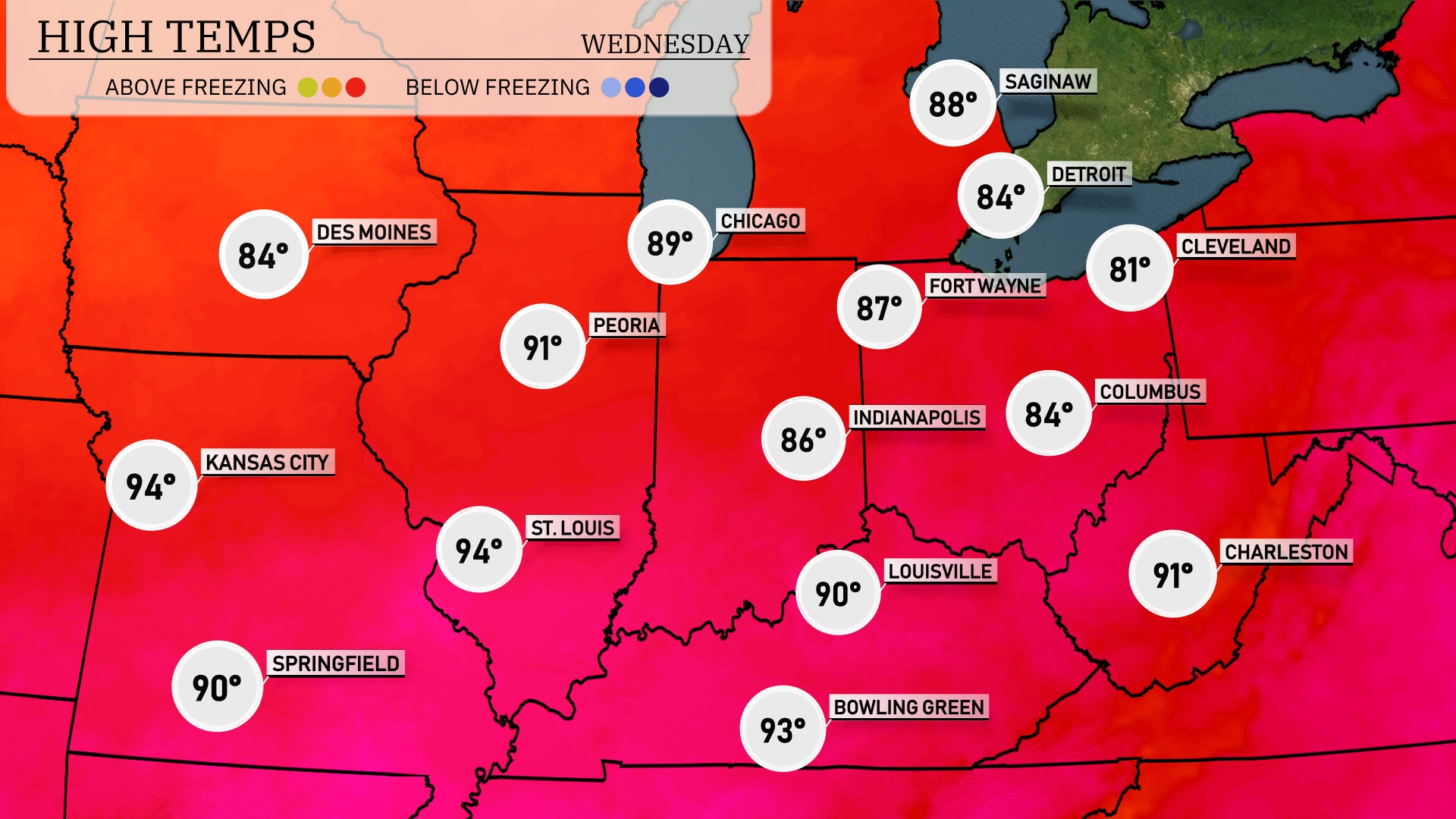
Tomorrow in the Midwest, expect another hot day with temperatures soaring. Kansas City and St. Louis will hit a scorching 94 degrees, while Peoria reaches 91 degrees. Chicago is set to warm up to 89 degrees, and Indianapolis is looking at a high of 86. Temperatures are well above average, influenced by a broad area of high pressure settling in. Residents in the region should prepare for heat, staying hydrated and cool.
A developing low-pressure system will bring scattered thunderstorms to the Midwest tomorrow, particularly from Peoria to Cleveland. Watch for heavy downpours and gusty winds, especially around Indianapolis and Fort Wayne, as these storms roll through. The severe weather threat is marginal, but local downpours could cause brief flooding in low-lying areas. Temperatures will hover in the mid-80s with increased humidity, making it a sticky day.
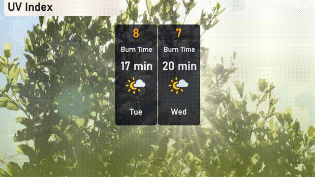
The UV index in Chicago is expected to be very high on Tuesday with a value of 8, resulting in a quick burn time of just 17 minutes in direct sunlight. By Wednesday, the index remains elevated at 7, with a burn time of approximately 20 minutes.
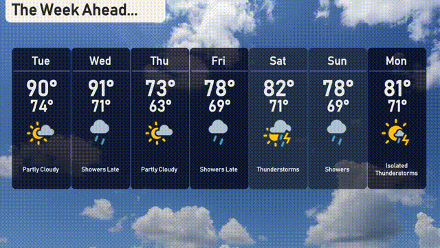
Tuesday: A warm day with partly cloudy skies, expect a high of 90 degrees and a low of 74 degrees.
Wednesday: Showers rolling in late, with temperatures reaching a high of 91 degrees and cooling to 71 degrees.
Thursday: Partly cloudy conditions with a high temperature of 73 degrees and a low of 63 degrees.
Friday: Showers may develop later in the day, with highs around 78 degrees and a low of 69 degrees.
Saturday: Thunderstorms are likely, with a high of 82 degrees and a low of 71 degrees.
Sunday: More showers expected, with the temperature peaking at 78 degrees and a low of 69 degrees.
Monday: Isolated thunderstorms are possible, with a high of 81 degrees and a low of 71 degrees.