Chicago’s Weather Rollercoaster: From Serene Sunsets to Stormy Nights
By
Amy Freeze
Experience the dynamic shifts in Chicago's weather with insights from Meteorologist Amy Freeze. Perfect sunsets give way to stormy forecasts.
Meteorologist Amy Freeze guides you through an array of weather changes in Chicago, from calm evenings to looming storm fronts.
In this detailed blog post, Amy Freeze, your trusted meteorologist, outlines the fascinating shifts in Chicago’s weather. Clear evenings with stunning sunsets swiftly change as significant rain systems move across the Midwest. Learn what these changes mean for your week, from temperature fluctuations to storm warnings.
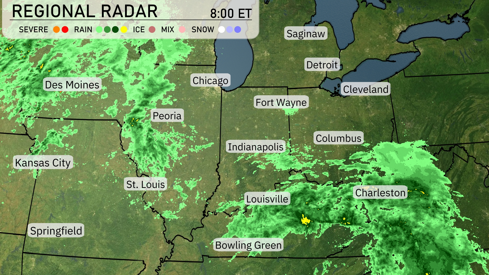
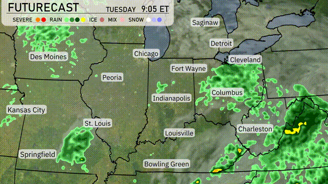
A widespread rain system is impacting much of the Midwest with significant cloud cover and precipitation. Heavy rain stretches from Des Moines across into Peoria, with areas farther east like Chicago experiencing light rain showers. Indianapolis and Louisville are now under steady rain, which is extending northeast toward Columbus. The rain is also moving into more southern areas, including Bowling Green, bringing moderate rainfall. Cleveland and Detroit are seeing lighter, patchy rain, with more intense weather expected as the system advances.
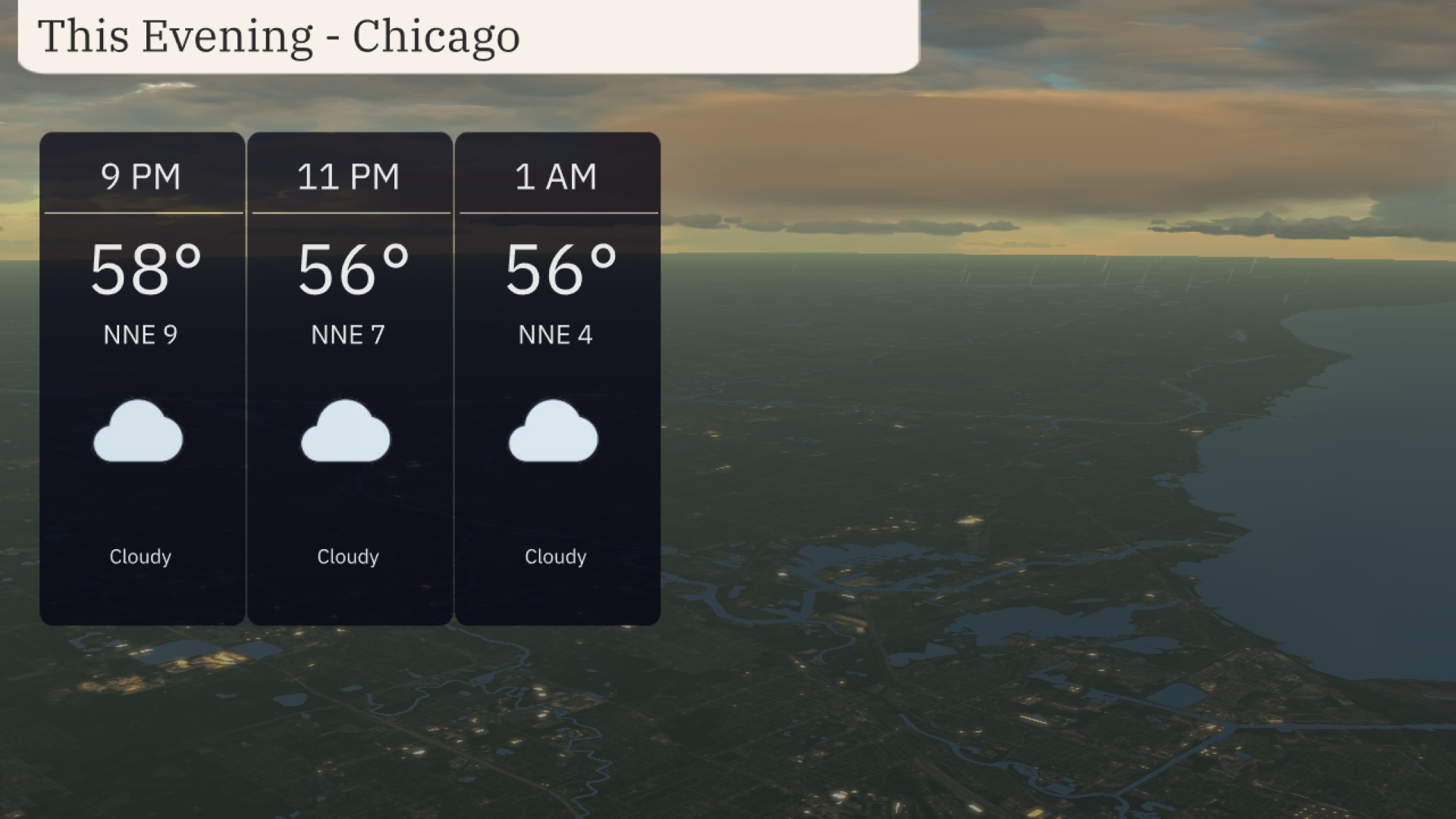
In Chicago this evening, temperatures will hover around 58 degrees at 9 PM, dipping slightly to 56 degrees by 11 PM and holding steady through the early morning hours. Expect consistent cloud cover throughout the night. Winds will be light, coming from the north-northeast at speeds decreasing from 9 to 4 miles per hour.
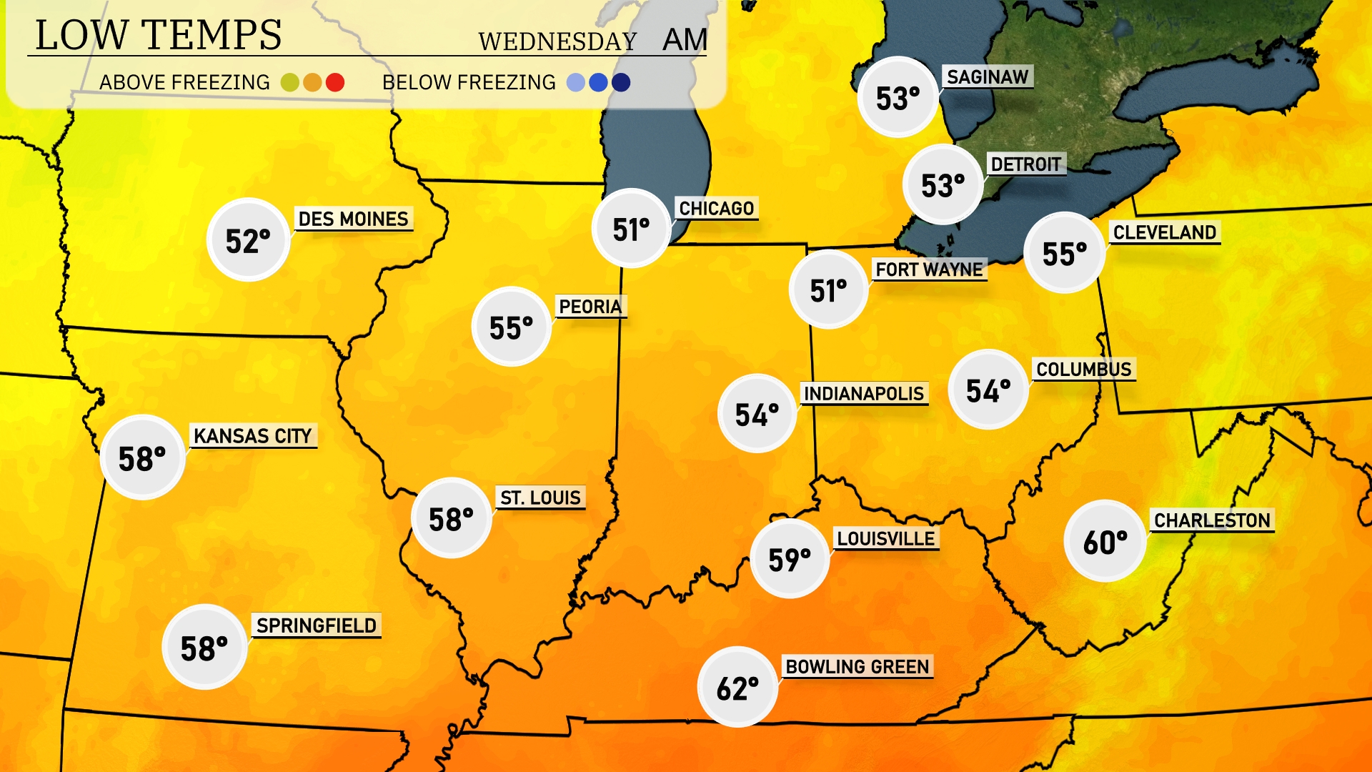
Low temperatures tonight across the Midwest will be quite chilly. Chicago will see a low of 51 degrees, while Indianapolis is expected to drop to 54. Detroit and Fort Wayne are not far behind, settling at 53 degrees. Kansas City will experience a mild night at 58 degrees, along with Springfield. Expect lows in Peoria and St. Louis both around 55 degrees.
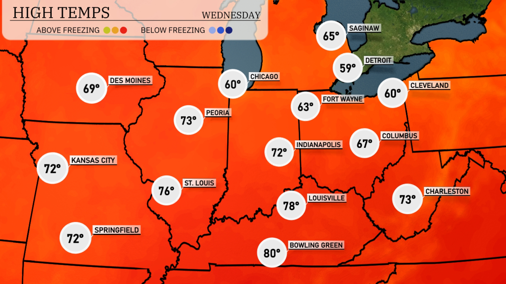
High temperatures tomorrow in the Midwest are trending above average as warm air dominates the region. Louisville is set to reach a high of 78 degrees, while Bowling Green could see a peak of 80. Indianapolis and Kansas City will be warm as well, with highs around 72 degrees. Chicago is slightly cooler at 60 degrees, impacted by lingering cloud cover.
A complex weather system is poised to impact the Midwest tomorrow. Showers and thunderstorms are expected from St. Louis to Columbus, with Indianapolis likely experiencing periods of heavy rain, causing possible localized flooding. A cold front will arrive late Tuesday night, bringing cooler temperatures. Watch for the potential of isolated strong storms from Peoria to Chicago, especially in the late afternoon and evening.
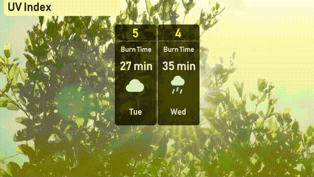
Chicago’s UV index on Tuesday will be moderate at 5, leading to a burn time of about 27 minutes under clear skies. On Wednesday, cloud cover from rain will reduce the UV index to 4, extending the burn time to 35 minutes.
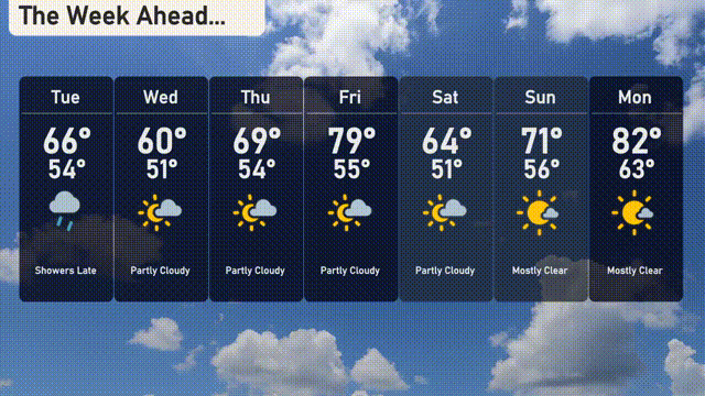
Tuesday: Showers late with a high of 66 degrees, cooling down to 54 at night.
Wednesday: Partly cloudy skies, expecting a high of 60 degrees and a low of 51.
Thursday: Some sun breaking through with a high of 69 degrees, dipping to 54 overnight.
Friday: Partly cloudy conditions, as temperatures rise to 79 degrees by day, with a low of 55.
Saturday: More sun and clouds mixed, reaching a high of 64 degrees with lows of 51.
Sunday: Mostly clear and pleasant, enjoy a high of 71 degrees, cooling to 56 overnight.
Monday: Mostly clear skies to start the week, with temperatures soaring up to 82 degrees and a low of 63.