Chicago’s Weekly Weather Forecast: Sun, Showers, and Surprises!
By
Amy Freeze
Explore the ups and downs of Chicago’s weather this week, from pleasant sunny days to incoming thunderstorms. Get all the insights to stay prepared!
Read our latest blog post for a detailed account of Chicago’s weather this week, featuring sunny days, mild nights, and potential storms. Stay weather-aware with our expert insights!
This week, Chicago and the surrounding Midwest region are riding a weather rollercoaster, featuring partly cloudy skies, scattered thunderstorms, and rising temperatures. As we navigate from temperate sunny days to stormy nights, it’s crucial to stay prepared. From high UV indices warning of quick sunburns to pleasant evenings perfect for outdoor activities, our comprehensive post breaks down what you need to expect and how to make the most of your week, weather-wise. Don’t miss out on our safety tips and day-by-day forecast to keep you ahead of the weather game!
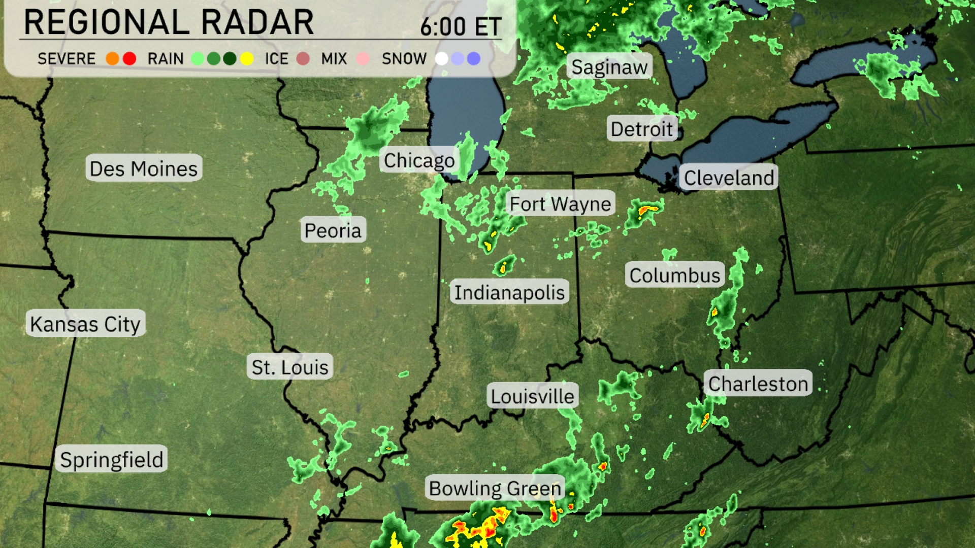
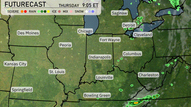
A line of showers and thunderstorms is extending from Bowling Green moving toward Louisville and Indianapolis. More isolated showers and storms are seen around Fort Wayne, descending southeast toward Columbus. Chicago and Des Moines are enjoying dry conditions, while rain is diminishing around the Detroit area. Light to moderate rain showers are spreading over Cleveland, heading eastward.
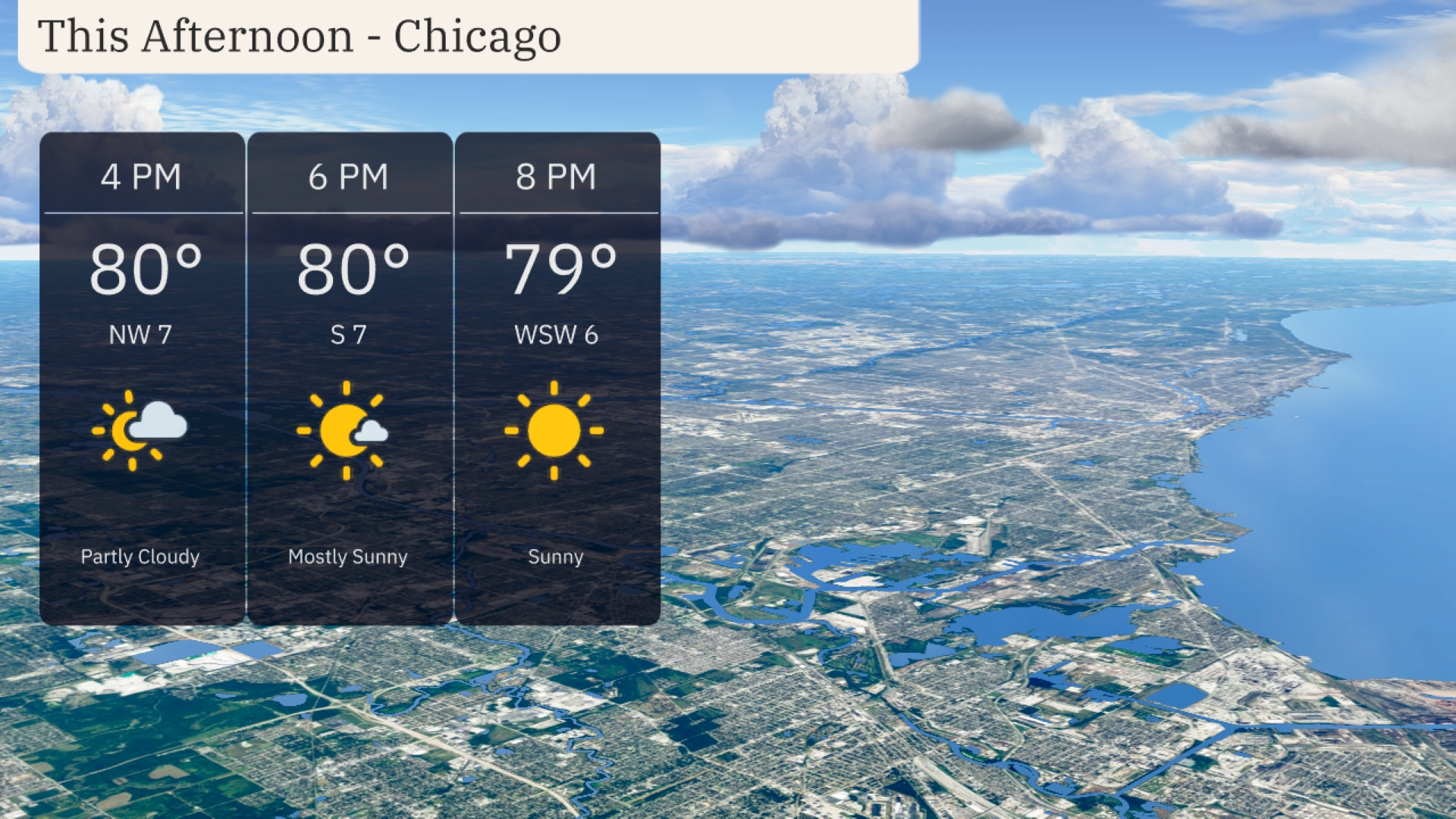
Afternoon temperatures in Chicago remain steady at 80 degrees with mostly sunny skies. Wind shifts from the northwest at 7 miles per hour to the south at 7 miles per hour by 6 PM, bringing comfortable breezy conditions. As the evening approaches, expect temperatures to slightly dip to 79 degrees with clear skies continuing. Enjoy the sunnier weather with light winds from the west-southwest at 6 miles per hour.
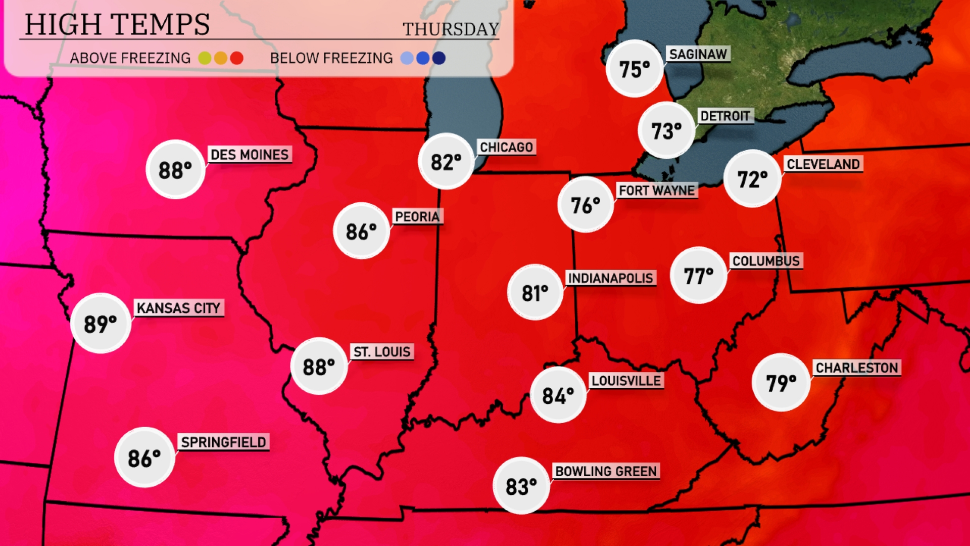
Today, temperatures are warming up nicely across the Midwest. Kansas City is leading the charge with a high of 89 degrees, closely followed by Des Moines at 88. St. Louis will also see a warm day with temperatures reaching 88 degrees, while Peoria checks in at a comfortable 86. Over in Indiana, Indianapolis hits a high of 81, which is a stark contrast to the cooler 72 degrees in Fort Wayne. Farther southeast, Louisville enjoys a pleasant 84 degrees, making for a beautiful day ahead.
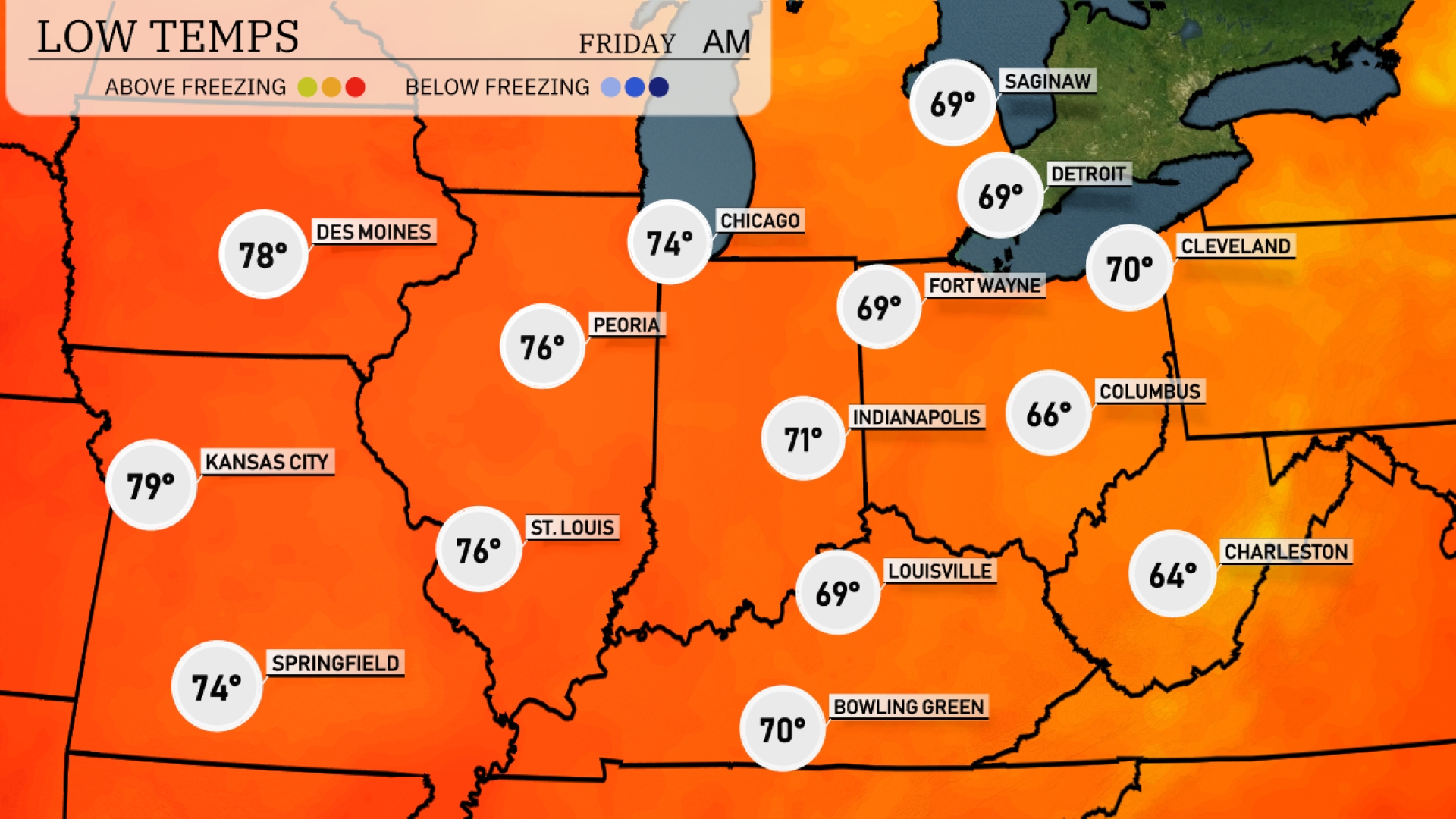
Tonight, temperatures will dip into the upper 60s across much of the Midwest. Chicago will see a low of 69 degrees, while Indianapolis is expected to cool down to 66. Further south, Louisville will rest at 69 degrees, and Columbus will drop to 66. Expect a milder night in St. Louis with a low of 76, well above the regional average.
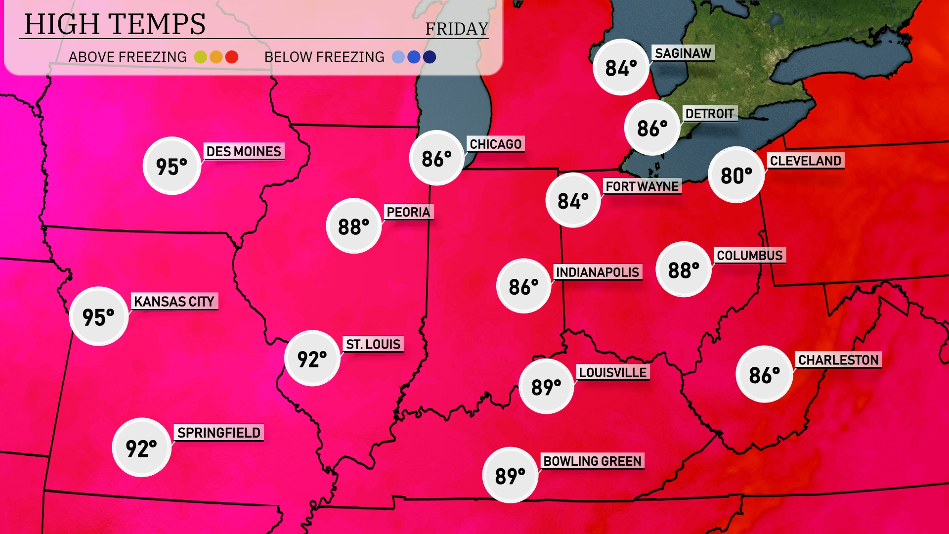
Tomorrow in the Midwest, Kansas City and Des Moines are both expected to reach a sizzling 95 degrees, marking above-average temperatures for this time of year. St. Louis will see highs near 92 degrees, while Peoria and Indianapolis will warm up to 88 degrees. Chicago is forecasted for a pleasant 86 degrees, and cooler temps will hit Fort Wayne and Detroit at 84 degrees.
A cold front is set to push through the Midwest, bringing scattered thunderstorms and heavy rain, particularly from Des Moines to Louisville. Temperatures will dip slightly behind the front, offering cooler, more comfortable conditions by Thursday afternoon. Chicago and Indianapolis could see localized flooding with intense rainfall over brief periods, so remain weather-aware. Thunderstorms will clear out by late Thursday, leading to a dry and pleasant weekend across the region.
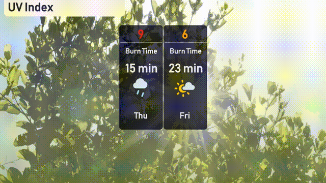
Chicago’s UV index is expected to hit a high of 9 on Thursday, warning of a burn time of just 15 minutes under direct sunlight. Friday sees a moderate UV level of 6, with a longer burn time of 23 minutes.