Dynamic Weather Patterns Sweep the Southwest: A Detailed Look with Amy Freeze
By
Amy Freeze
Explore the diverse weather landscape across the Southwest with expert insights from Meteorologist Amy Freeze, featuring temperature shifts, clear skies, and regional forecasts.
Meteorologist Amy Freeze provides a snapshot of the unfolding weather scenarios across the Southwest: From partly cloudy skies in Salt Lake City to rain showers in northern Nevada and Arizona’s potential thunderstorms.
In this detailed article, Amy Freeze delves into the Southwest’s current atmospheric conditions and upcoming weather patterns. From the mild temperatures in Las Vegas to sudden showers in Cedar City and the chance of severe storms in Arizona and New Mexico, get prepared with essential insights to navigate the fluctuating southwest weather.
A dynamic weather scenario is unfolding in the Southwest! On the regional radar, rain showers are making their way across northern Nevada, with Ely experiencing precipitation. Cedar City in Utah is under rain as well. Flagstaff is seeing some light showers, and surrounding areas in Arizona are witnessing cloud cover. In the vicinity of San Francisco and Fresno, skies are mostly clear, providing welcome dry conditions.
For this afternoon in Salt Lake City, temperatures will start at 71 degrees and slightly drop to 66 degrees by evening. Winds will shift from the southeast at 8 mph to the west up to 12 mph.
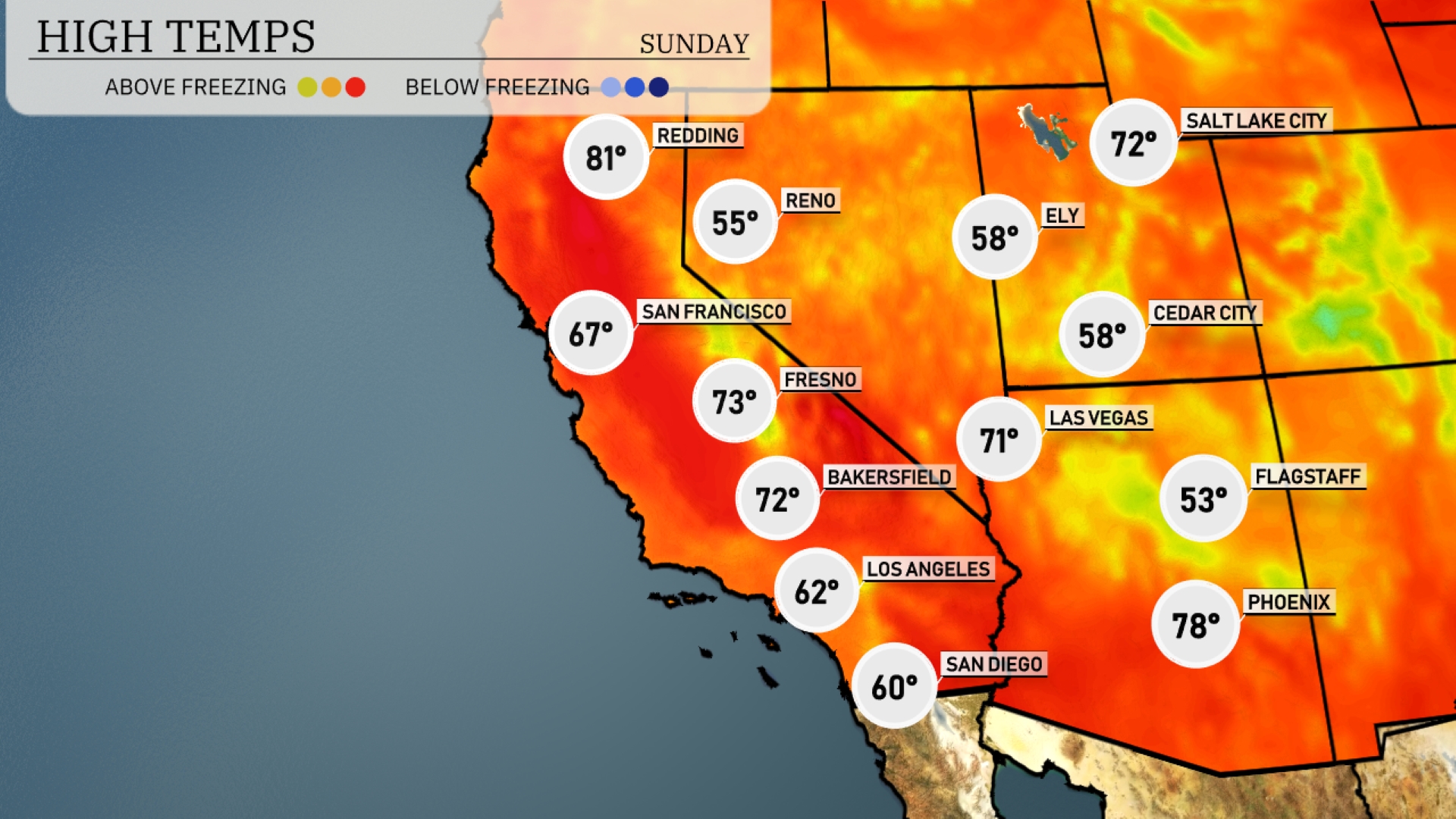
In the Southwest today, temperatures are warming up nicely. Phoenix will see a high of 78 degrees, while Las Vegas isn’t far behind at 71. Bakersfield is looking at a pleasant 72, and Fresno reaches 73 degrees. Meanwhile, San Diego stays cool at 60. Flagstaff will only hit 53 degrees, showcasing a significant contrast with the warmer low deserts. Ely and Cedar City are also on the cooler side, both expected to see highs around 58 degrees.
Flagstaff is looking at a chilly low of 32 degrees, while Ely is expected to dip to a frigid 30 degrees. Las Vegas will see a low of 59, remaining relatively mild compared to northern cities. In Los Angeles, the forecast shows a low of 55 degrees, and San Diego will cool down to 54. Phoenix is expected to start the day at a warmer 60 degrees.
High temperatures in the Southwest are expected to be warm and above average tomorrow. Las Vegas will reach a comfortable 66 degrees, while Phoenix enjoys a high of 71. San Diego is set to have a mild day with temperatures peaking at 65 degrees. Further inland, Fresno will experience warmer conditions, hitting 82 degrees, and Bakersfield is looking at a high of 84 degrees.
The Southwest is set for an active weather pattern tomorrow with thunderstorms developing primarily in Arizona and New Mexico. Expect showers from Tucson to Albuquerque as moisture continues to move eastward. Temperature trends remain consistent, with highs in the upper 70s and low 80s, cooling down slightly post-rain. Northern Arizona might see heavy downpours, raising concerns for flash flooding in lower-lying areas. Be aware as isolated severe storms with gusty winds are possible, particularly in the mountain regions.
The UV index in Salt Lake City will be moderate with a value of 5 on Sunday, posing a burn time of approximately 27 minutes under clear skies. On Monday, expect the UV index to slightly increase to 6, bringing a quicker burn time of about 23 minutes.