Sunny Days and Crisp Nights: Navigating LA’s April Weather Wonders
By
Amy Freeze
Explore how Los Angeles's weather adapts from sunny afternoons to chilly nights and what it means for your week ahead.
Meteorologist Amy Freeze brings you the latest on Los Angeles’s varied weather patterns, from clear skies in the Southwest to unexpected rain and snow showers. Stay prepared and informed!
Dive into the detailed weather forecast for Los Angeles and surrounding areas as Amy Freeze gives a day-by-day breakdown. From temperature trends to UV index warnings, find out how to best prepare for potential weather shifts and enjoy the clear days ahead. Read more about the region-specific forecasts including precipitation chances and temperature dives in the blog.
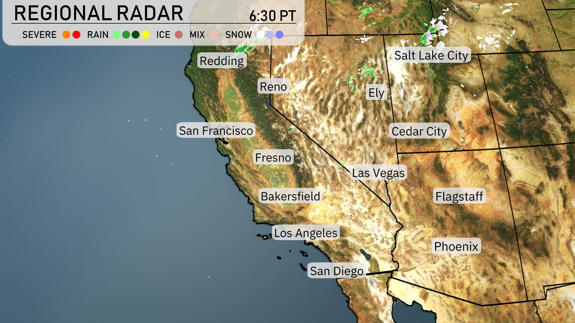
On the regional radar, a mix of rain and snow showers is visible primarily over Reno, while the higher elevations near Salt Lake City are experiencing snow. Cedar City and Ely are witnessing some scattered rain showers moving eastward. The skies remain clear and dry across most of California, including San Francisco, Los Angeles, and San Diego. In the Southwest, Las Vegas and Phoenix are enjoying a break from precipitation, with clear skies dominating the scene. Flagstaff is experiencing overcast conditions with the potential for light showers.
This afternoon in Los Angeles, temperatures will hover in the low 60s, peaking at 63 degrees around 5 PM with a gentle breeze from the SSW at 8 miles per hour. Expect the skies to shift from mostly cloudy to partly cloudy as the afternoon progresses, eventually leading to mostly sunny conditions by 7 PM.
Afternoon high temperatures in the Southwest are on the rise today. In Las Vegas, expect a sizzling high of 87 degrees. Phoenix is even warmer at 91 degrees, making it one of the hottest locations in the region. Meanwhile, temperatures are a bit cooler in San Diego, reaching only 65 degrees, while Los Angeles will enjoy a high of 64 degrees. Further north, Bakersfield will see a pleasant 85 degrees, and Fresno is at 81. Flagstaff stands out with only a high of 65 degrees, showcasing the temperature contrasts across the region.
Tonight in the Southwest, temperatures are dropping significantly. Flagstaff will see a chilly low of 35 degrees, while Ely gets even colder at 36 degrees. Las Vegas is expected to cool down to 62 degrees, and Bakersfield will rest at 51. San Francisco and Fresno both anticipate lows of 50 degrees. Los Angeles will remain mild at 52 degrees.
High temperatures tomorrow in the Southwest are trending well above average. Phoenix will see a sweltering high of 91 degrees, while Las Vegas is expected to reach 87 degrees. Further west, Bakersfield warms up to 80 degrees, and Los Angeles will be milder at 67 degrees. San Diego reports a comfortable high of 66 degrees.
The Southwest is in for a notable weather shift over the next 48 hours. Northern California will experience multiple rounds of valley rain from Tuesday into Wednesday, with the potential for heavy showers and tricky driving conditions in the San Bernardino Valley of Southern California. Meanwhile, expect clear skies and warm temperatures in the desert Southwest. Pay attention to the areas affected by showers moving in from the west, as these could bring brief but impactful weather changes. The rest of the region remains largely dry, with no severe weather threats evident at this time.
The UV index in Los Angeles is projected to reach 7 today, with a burn time of approximately 20 minutes in direct sunlight. As we move to Thursday, the index climbs to 8, shortening the burn time to just 17 minutes.