From Heat Waves to Thunderstorms: Navigating Los Angeles’ Diverse Weather Patterns
By
Amy Freeze
Discover the dynamic weather swing in Los Angeles from blazing heat to unexpected thunderstorms. Learn how these patterns impact your weekly plans.
Explore how Los Angeles’ weather swings from hot sunny days to cool evening thunderstorms and what these changes mean for your daily activities.
https://www.youtube.com/watch?v=MNkc155w9pg
This week in Los Angeles and the broader Southwest, weather conditions range from scorching hot days to potentially hazardous thunderstorms. In our latest blog post, we break down the daily forecasts, discuss the implications of a high UV index, and offer safety tips for dealing with extreme weather. Whether you’re planning an outing or just going about your daily routine, understanding these patterns is key to staying safe and making the most of the region’s diverse climate.
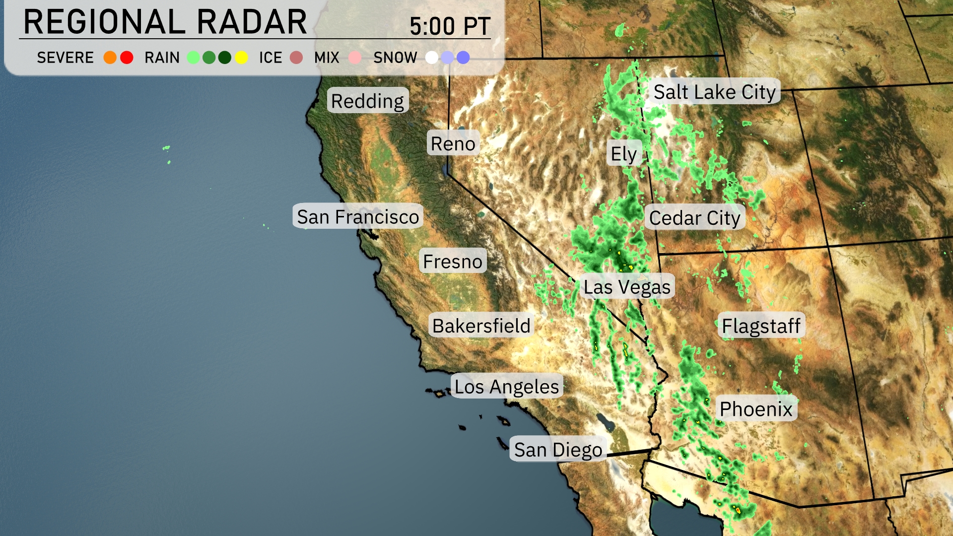
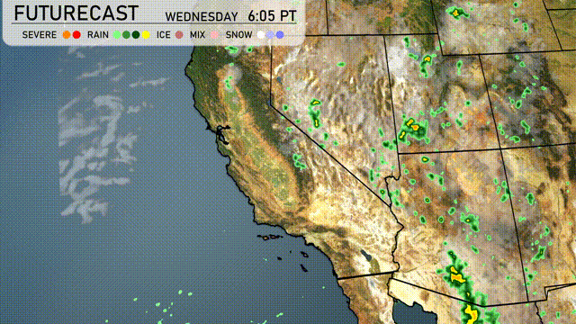
A swath of rain showers is sweeping across the high desert from Ely, Nevada, down through Cedar City, Utah, bringing wet conditions to these areas. Flagstaff is also under the influence of light rain, while Salt Lake City experiences another band of showers moving through. Phoenix and Las Vegas remain dry, showing clear conditions around their urban centers. The coastal cities like San Francisco and San Diego are enjoying clearer skies with no immediate precipitation.
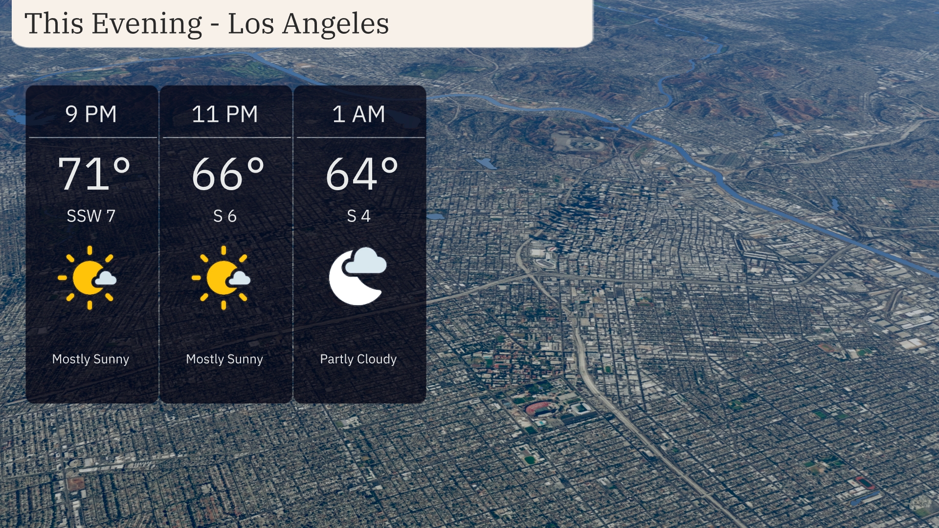
For this evening in Los Angeles, temperatures will start at 71 degrees at 9 PM, dipping to 66 degrees by 11 PM, and further cooling to 64 degrees by 1 AM. Expect mostly sunny skies transitioning to partly cloudy conditions as the evening progresses. Winds will be gentle, coming from the south-southwest at 7 mph initially, tapering to 4 mph by the early hours.
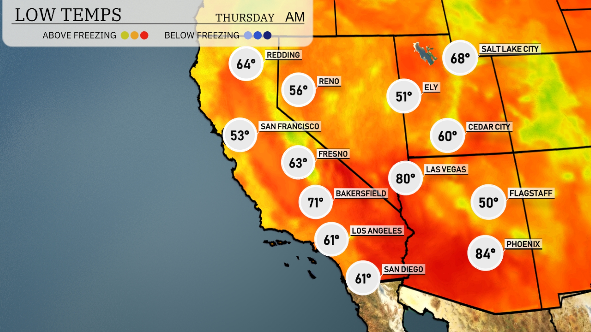
Tonight in the Southwest, expect lows to dip significantly with Flagstaff at 50 degrees. Ely will be even colder with a low of 51. Las Vegas remains relatively warm at 60 degrees, while Los Angeles cools down to 61. Bakersfield will experience a low of 71, marking a sharp drop in temperatures for the region.
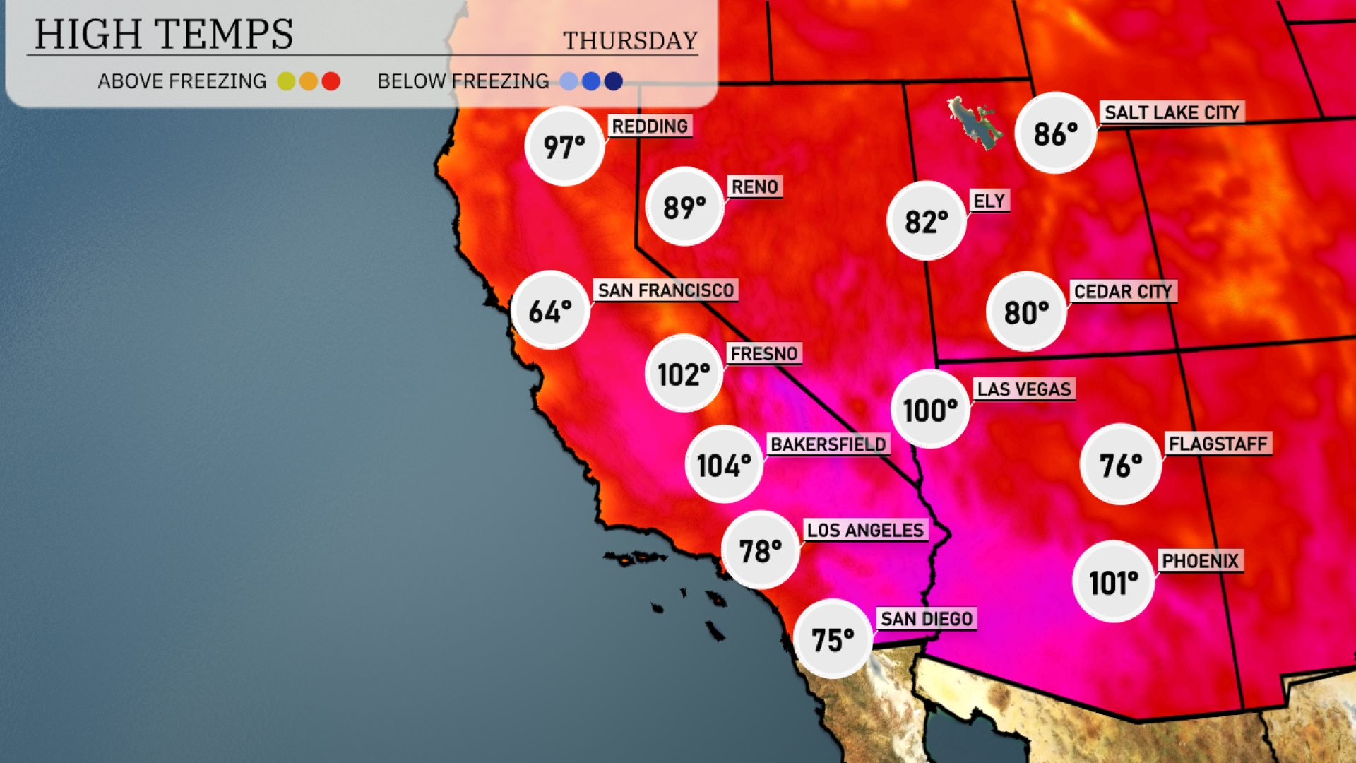
Tomorrow in the Southwest, Las Vegas will reach a sizzling 100 degrees, while Phoenix isn’t far behind at 101. Bakersfield is set to soar to a steamy 104 degrees, significantly above average for this time of year. San Diego will enjoy a milder afternoon at 75 degrees, and further north, Fresno will also see a high of 102.
A cold front is set to push into the Southwest tomorrow, sparking scattered thunderstorms from Arizona to Nevada. Expect moderate rainfall with the potential for flash flooding in low-lying areas, particularly around Phoenix and Tucson. High temperatures will cool to the mid-80s as the system passes, providing some relief from the usual heat. Meanwhile, southern Nevada could see severe isolated storms, so stay alert for high winds in the area. Clear skies will gradually emerge by Thursday evening across most of the region.
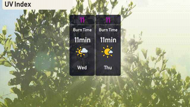
The UV index in Los Angeles for Wednesday is an extreme 11, with a burn time of just 11 minutes, so exercise caution. Protect your skin by applying sunscreen frequently, wearing hats, and seeking shade. Thursday continues the trend with another extreme UV index of 11, maintaining the same quick burn time.
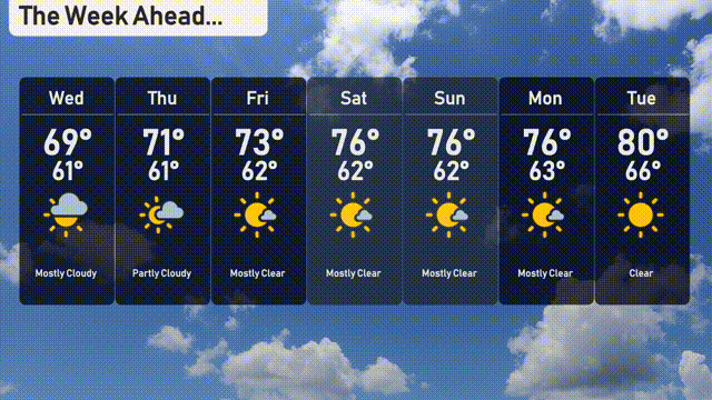
Wednesday: Mostly cloudy with a high of 69 degrees and a low of 61 degrees.
Thursday: Partly cloudy skies, warming slightly to a high of 71 degrees, with a low of 61 degrees.
Friday: Enjoy mostly clear weather with temperatures reaching a high of 73 degrees and a low of 62 degrees.
Saturday: Mostly clear skies continue, with a daytime high of 76 degrees and a nighttime low of 62 degrees.
Sunday brings more sunshine with another high of 76 degrees and a low around 62 degrees.
Monday: The sunny trend persists, peaking at 76 degrees with a low of 63 degrees.
Tuesday: Enjoy a clear day with the temperature reaching 80 degrees and a low of 66 degrees.