Sweeping Skies and Cooling Nights – Your Detailed Southwest Weather Forecast
By
Amy Freeze
Meteorologist Amy Freeze provides a comprehensive look at the diverse weather conditions sweeping across Los Angeles and the broader Southwest region. From gentle winds to unexpected snowfalls, here's what to expect right outside your door.
Tonight in Los Angeles, expect clear conditions with cooling temperatures as Meteorologist Amy Freeze takes you through the regional weather variations, from calm desert warmth to snowy mountain passes.
Detailed evening forecast by Amy Freeze covering city-wise temperatures and conditions across the Southwest region. Learn about how the weather will affect your week from clear sunny skies to potential rain and gusty winds in certain areas. Prepare for what the weather holds with insights on temperature fluctuations and safety tips.
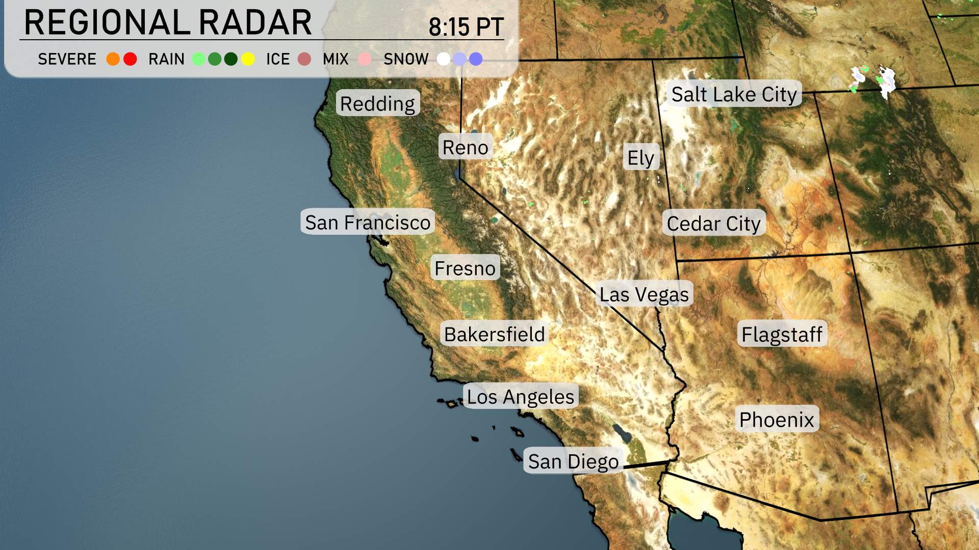
The Regional Radar for the Southwest shows an interesting mix of conditions today. Rain showers are making their way from the Pacific, offering relief along the central California coastline. Places like Fresno and Bakersfield are experiencing light rain, with a more significant chance for showers expected as you move closer to the higher elevations where snow is falling. This includes areas around Reno and reaching up to Salt Lake City, where snow will likely blanket the landscape.
The conditions in San Francisco and Los Angeles are relatively mild, with cloudy skies but minimal rainfall. Moving east, Flagstaff has the potential for light snow showers, emphasizing the wintry feel of the region, whereas Phoenix stays dry and clear under the desert sun.
This system is set to bring strong winds, particularly in the mountainous regions where gusts can reach as high as 75 miles per hour, making travel through mountain passes challenging. As we glance at San Diego, dry conditions are anticipated.
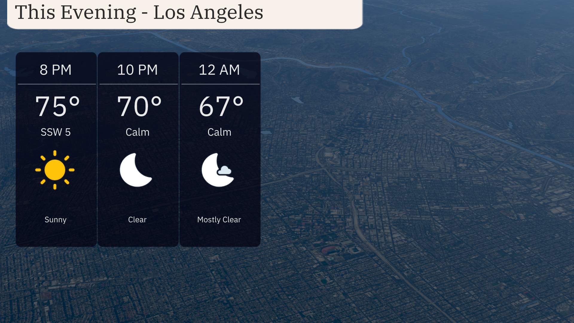
This evening in Los Angeles, clear skies will accompany a gradual cooling trend. At 8 PM, temperatures will be around 75 degrees with a gentle southwest wind at 5 miles per hour. By 10 PM, the air will be calm as temperatures dip to 70 degrees. Midnight brings mostly clear conditions, with temperatures settling at 67 degrees, providing a cool and pleasant end to your Monday.
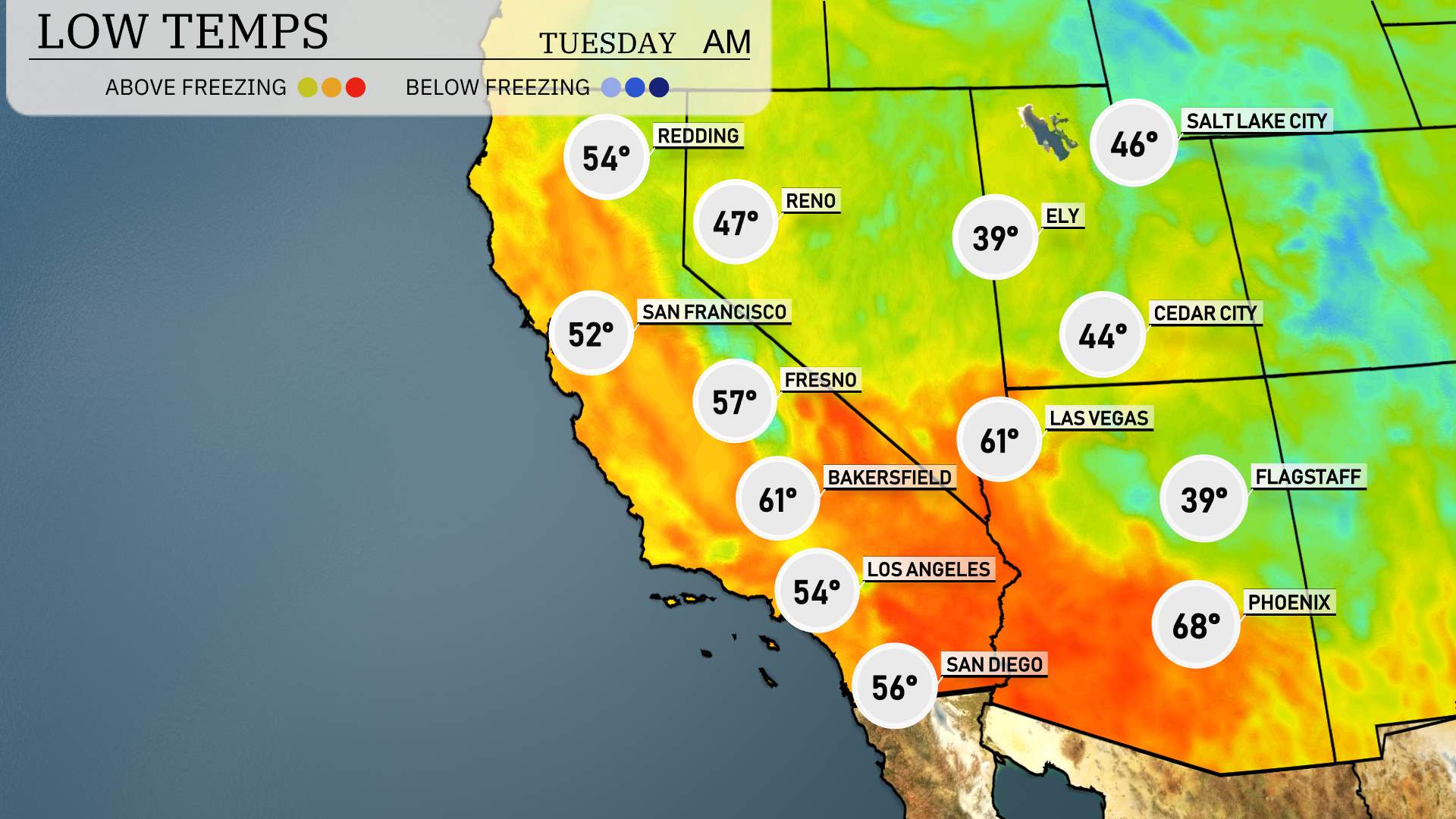
Tonight in the Southwest, temperatures will dip significantly, bringing a chill to the region. Las Vegas will see a cooler night with temperatures dropping to 61. Flagstaff is looking at a chilly 39 degrees, while Cedar City will be slightly warmer at 44. Moving to the coastal regions, San Francisco is forecasted to cool down to 52 degrees. In Southern California, Los Angeles will experience mild temperatures around 54, while San Diego will close out the day with a low of 56. S
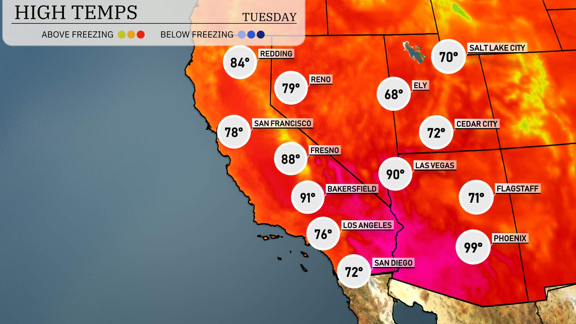
High temperatures for the Southwest region tomorrow are set to soar, with many areas experiencing above-average readings.
In California, Bakersfield will hit a sizzling 91 degrees, while Fresno warms up to 88 degrees. Over in Los Angeles, expect a comfortable 76 degrees, and San Diego will see a high of 72 degrees.
Moving to Nevada, Las Vegas is looking at a hot 90 degrees, which is well above the seasonal norm.
In Arizona, Phoenix is anticipated to reach a scorching 99 degrees, significantly above typical March highs. Flagstaff will remain milder at 71 degrees.
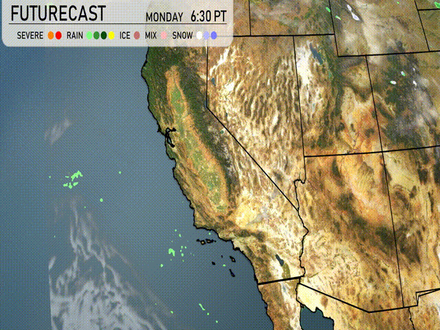
“On tomorrow’s futurecast for the Southwest, a mild weather pattern remains over the interior desert regions with plenty of sunshine. However, coastal areas of Southern California will see several rounds of rain, particularly over the San Bernardino Valley, which could lead to slick roads and challenging driving conditions. Northern parts of the region, including Arizona, remain largely dry. Be prepared for rain on the highways and lookout for local weather advisories.”
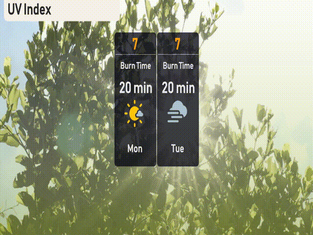
The UV index in Los Angeles is high, reaching 7 both today and Tuesday, with a burn time of about 20 minutes. Be sure to protect your skin by applying sunscreen and wearing protective clothing if you’re out enjoying the sunshine!
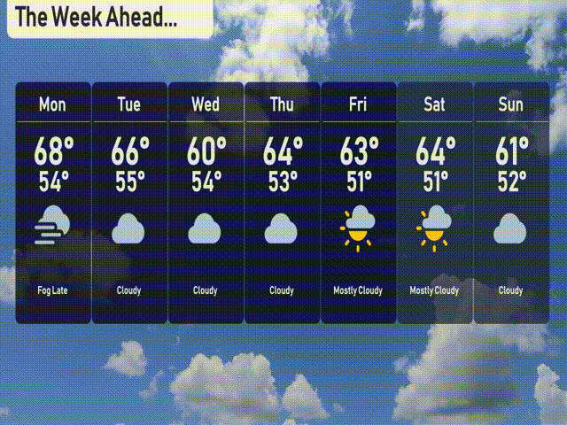
For the 7 day forecast in Los Angeles:
Monday: Cloudy conditions with a high of 68 degrees and a low around 54 degrees.
Tuesday: Expect clouds to linger with highs of 66 degrees and lows of 55 degrees.
Wednesday: More clouds are in store, with temperatures reaching a high of 60 degrees and a low of 54 degrees.
Thursday: The cloudy trend continues with highs around 64 degrees and lows at 53 degrees.
Friday: Mostly cloudy skies, but a bit of sunshine peeks through, achieving a high of 63 degrees with lows around 51 degrees.
Saturday: Mostly cloudy again, with temperatures rising to 64 degrees during the day and dropping to 51 degrees at night.
Sunday: Clouds return, with a high of 61 degrees and a low of 52 degrees.
Stay safe and hope that helps!