Los Angeles Evenings and the Puzzling Weather Pivots: An In-Depth Look with Amy Freeze
By
Amy Freeze
Explore how Los Angeles's stunning evenings and shifting weather patterns impact the city, from serene sunsets to sudden storms, with insights from meteorologist Amy Freeze.
Get the latest updates on Los Angeles weather with Amy Freeze! From picturesque sunsets to unexpected storms, we’ve got you covered.
Read more about how Los Angeles’s evening skies are evolving with meteorologist Amy Freeze’s detailed forecast. Discover the beauty of the city’s sunsets and learn about the significant weather changes affecting the Southwest. Stay informed with our in-depth analysis of upcoming weather patterns.
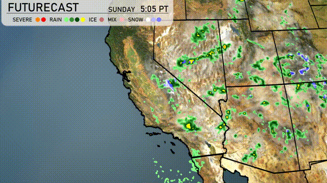
A cold front is bringing scattered rain showers and isolated thunderstorms across central Nevada, reaching towns like Ely. Light rain is impacting parts of Salt Lake City, extending southward into the mountains just west of Cedar City. The Sierra Nevada range near Reno is witnessing a mix of rain and snow, with higher peaks accumulating fresh snowfall, adding a wintery feel to the landscapes. The coastal regions from San Francisco to Los Angeles have clearer skies, providing a break from precipitation. Phoenix and San Diego remain mostly dry under partly cloudy conditions.
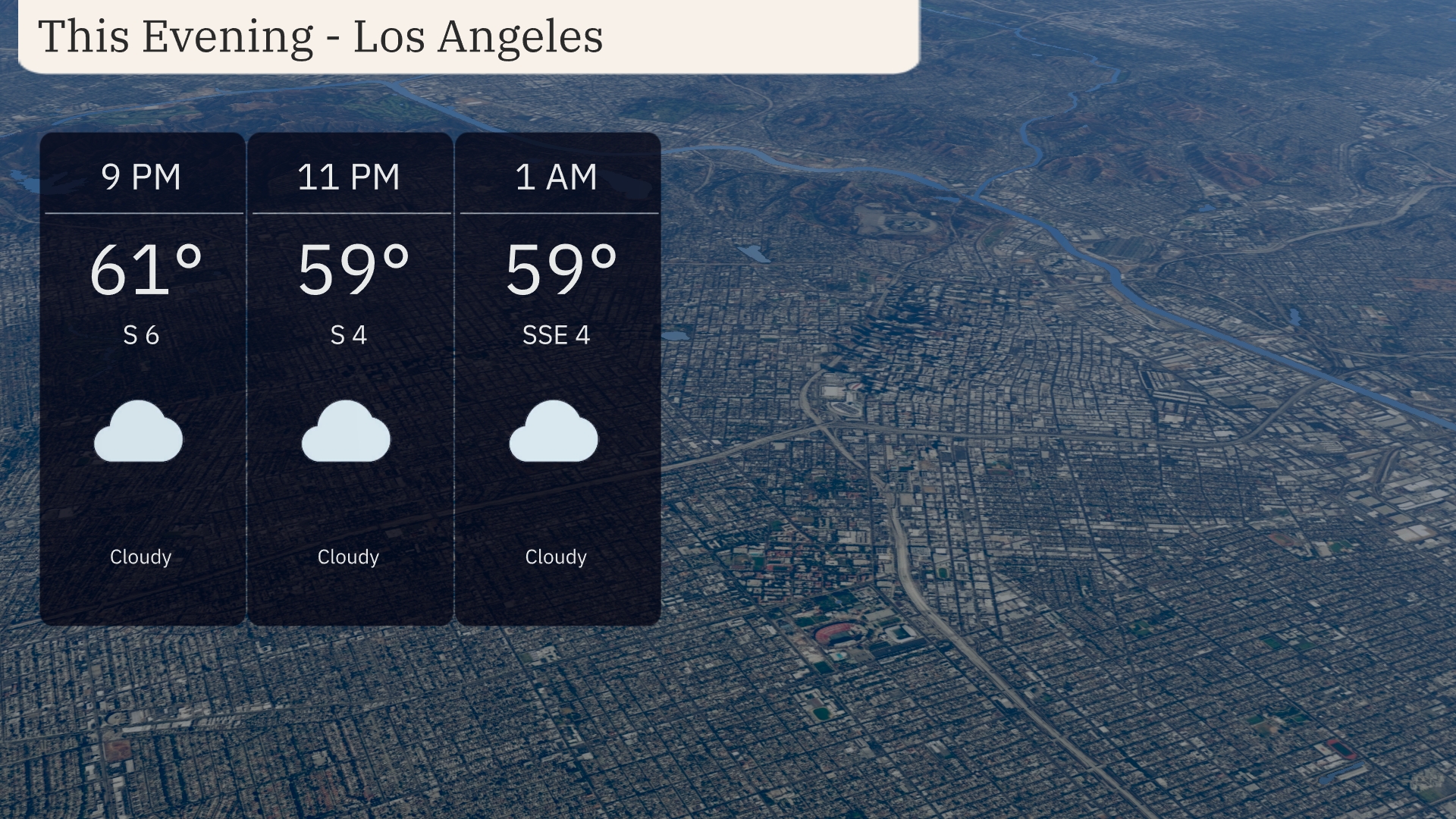
Evening in Los Angeles features cloudy skies with temperatures starting at 61 degrees by 9 PM. A light breeze from the south at 6 miles per hour is forecasted. By 11 PM, temperatures dip slightly to 59 degrees, with winds easing to 4 miles per hour. The trend continues into 1 AM with steady temperatures and calm SSE winds at 4 miles per hour.
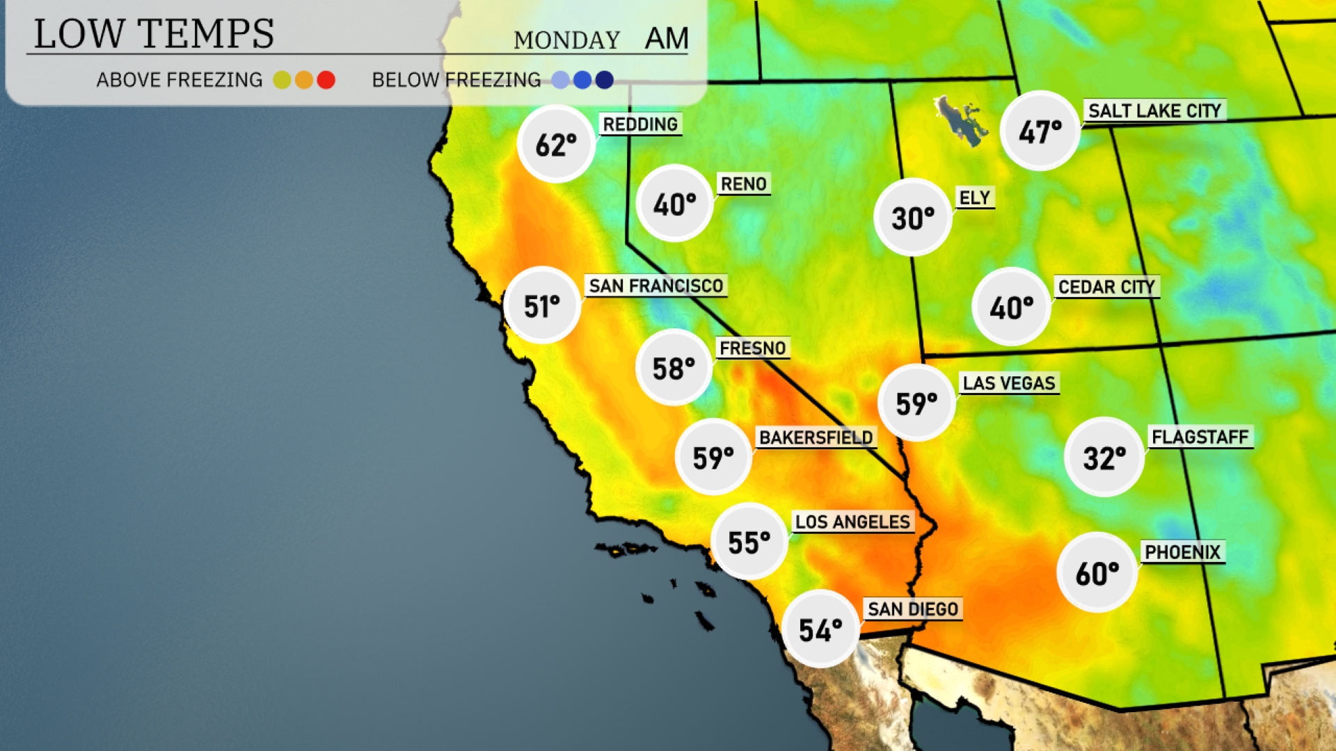
Flagstaff will be particularly chilly at 32 degrees, while Ely drops to a frosty 30. Las Vegas is set for a mild low of 59 degrees, but areas like Cedar City will chill down to 40. Los Angeles will cool off to 55 degrees, and down in San Diego, temperatures will rest at a comfortable 54.
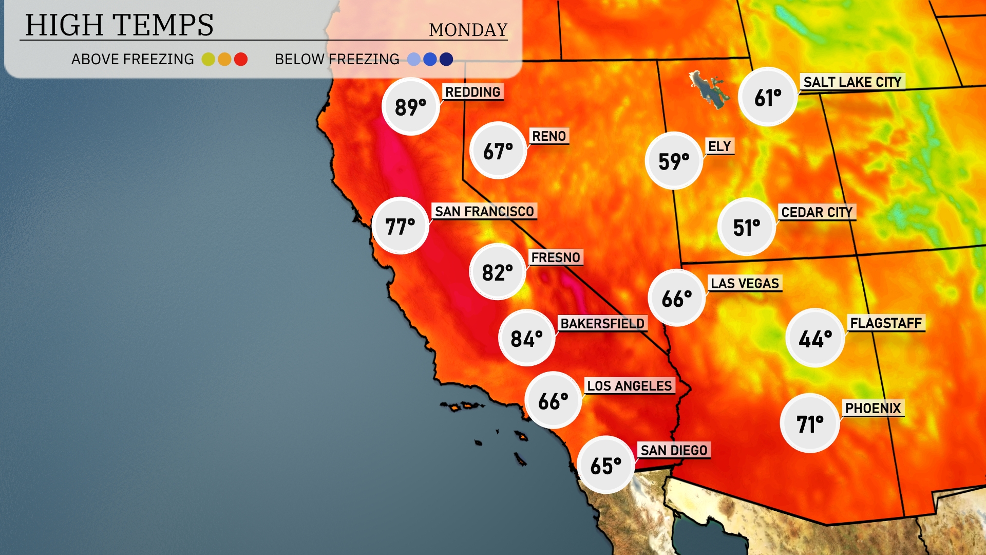
Tomorrow, the Southwest is poised for above-average temperatures as a warm air mass moves into the region. Las Vegas will see a high of 66 degrees, while Phoenix warms up to 71. In California, Bakersfield can expect a high of 84 degrees, and Fresno reaches 82 degrees. San Francisco will enjoy a mild day with a high of 77 degrees. San Diego remains cooler at 65 degrees, influenced by coastal marine layer conditions.
In the Southwest, expect a sharp weather change as a strong cold front enters from the north, bringing with it a surge of cooler air. This front will likely spark severe thunderstorms by late afternoon, particularly over Arizona and New Mexico, with the main threats being hail and damaging winds. Heavy rain is projected in lower elevations, raising concerns about flash flooding as new showers track eastward. Behind the front, anticipate temperatures dropping 10 to 15 degrees, offering a brief reprieve from the heat. By mid-week, skies will clear, allowing for a sunny and calmer pattern to take hold across much of the region.
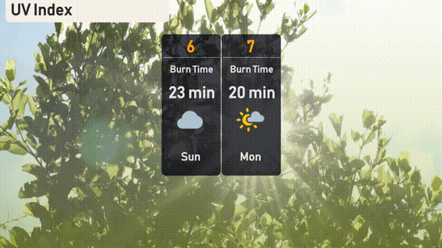
The UV index in Los Angeles is a moderate 6 for Sunday, with a burn time of about 23 minutes when basking under the sun. On Monday, expect the UV index to rise slightly to 7, making the sun stronger with a burn time of approximately 20 minutes.
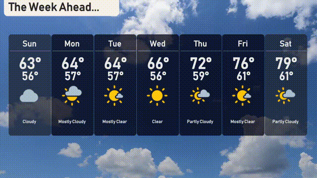
For the 7-day forecast in Los Angeles:
Sunday: Cloudy with a high of 63 degrees and a low of 56 degrees.
Monday: Mostly cloudy skies, temperatures reaching a high of 64 degrees and a low of 57 degrees.
Tuesday: Mostly clear conditions with a high of 64 degrees again and a low near 57 degrees.
Wednesday: A sunny day with comfortable temperatures — a high of 66 degrees and a low of 56 degrees.
Thursday: Partly cloudy skies as temperatures rise to 72 degrees with evening lows of 59.
Friday: Enjoy mostly clear skies with a slight warm-up, high of 76 degrees and lows of 61 degrees.
Saturday: Partly cloudy and even warmer, as temperatures reach 79 degrees and dip to 61 degrees come nightfall.