Los Angeles Weather Scoop: Sunsets, Storms, and Safety Tips
By
Amy Freeze
Explore a detailed forecast for Los Angeles: ranging from picturesque sunsets to impending storms, learn how to enjoy and stay safe during fluctuating summer weather.
This week in Los Angeles, expect a mix of sunny days and potential stormy shifts with tips on how to protect yourself from the extreme UV rays. Perfect for planning your week around the weather!
Welcome to your detailed weather forecast for Los Angeles and the Southwest. As you enjoy the gentle breezes and partly cloudy skies, remember to prepare for sudden weather changes. Here’s a breakdown from serene sunsets to storm warnings, along with safety tips during high UV index days. Whether you’re planning outdoor activities or just need to stay informed, this is your go-to resource for all weather-related updates.
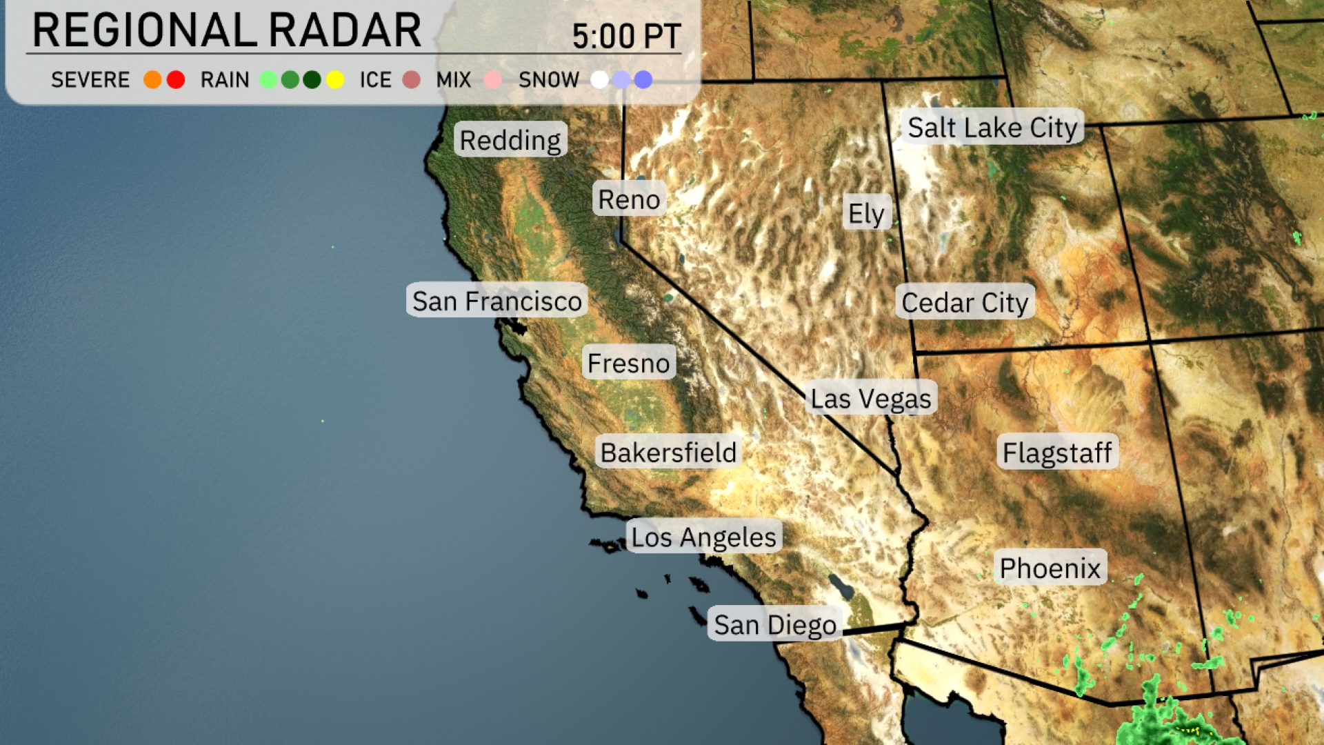
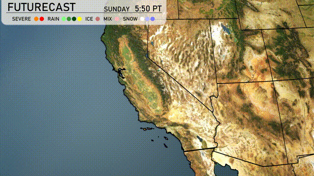
The Southwest is showing a mix of quiet and active weather patterns. Showers near Phoenix move north, affecting Flagstaff with potential rain. Las Vegas and Los Angeles stay dry under clear skies, while San Francisco faces approaching showers near the coast. The Sierra Nevadas near Ely and Cedar City remain calm, though Reno should anticipate some cloud cover soon.
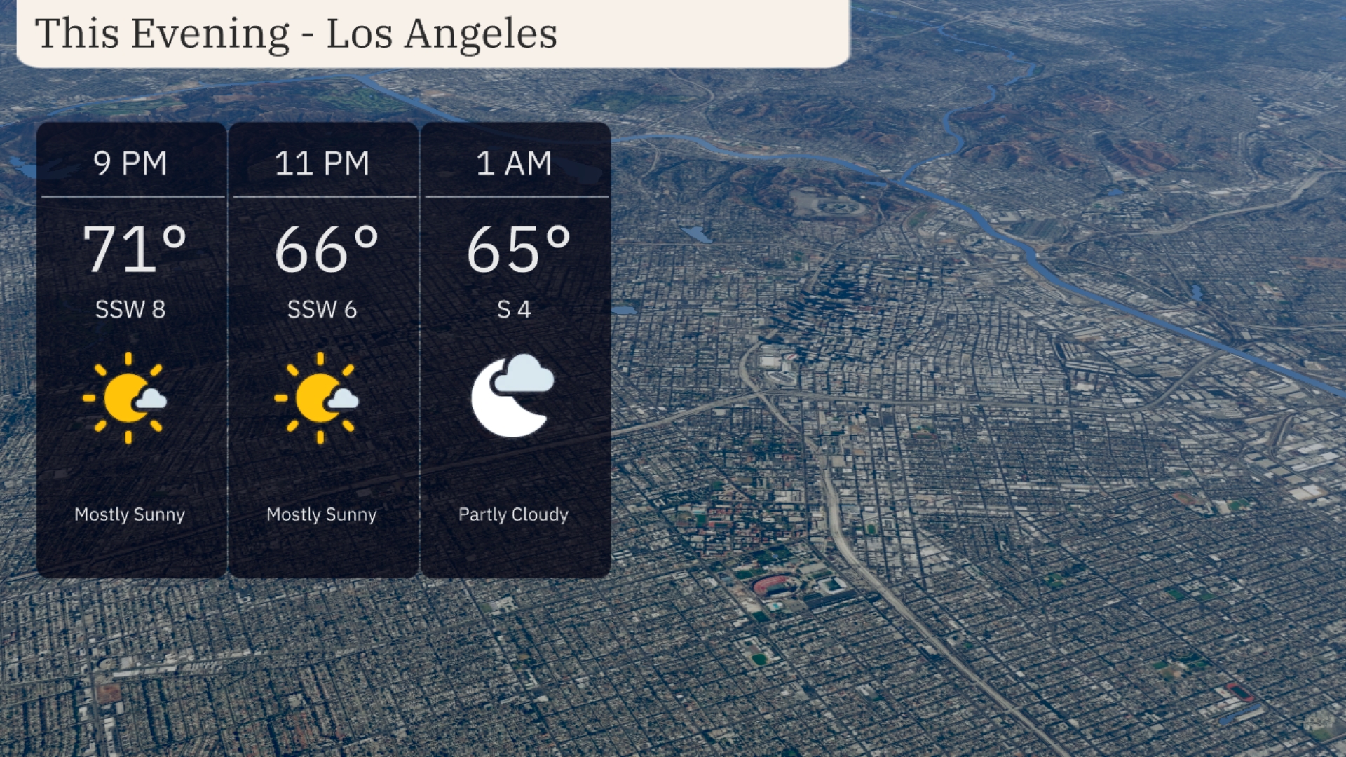
Temperatures in Los Angeles will start at 71 degrees at 9 PM, cooling down to 65 degrees by 1 AM. Expect mostly sunny skies early in the evening, transitioning to partly cloudy conditions. A gentle breeze from the south-southwest at 8 mph early on, becoming calmer overnight with winds shifting to the south at 4 mph. Plan for a comfortable, mild evening overall.
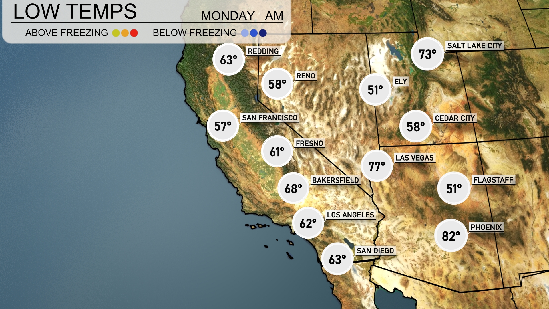
Tonight in the Southwest, Las Vegas will chill down to 77 degrees, while Flagstaff drops to a cool 51. Phoenix will remain warmer at 82 degrees, but nearby, Reno will see a low of 58. Expect farther dips with San Francisco at 57 and Bakersfield cooling to 68.
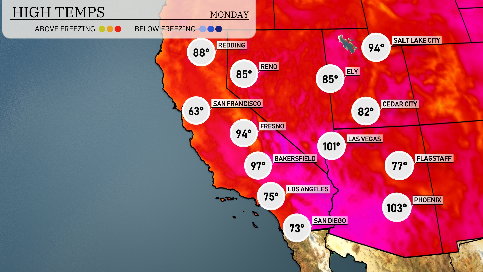
Tomorrow in Las Vegas, expect a sizzling high of 101 degrees, significantly above average for this time of year. Phoenix will be even hotter, reaching a blistering 103 degrees, contributing to ongoing heat advisories in the area. In contrast, San Francisco will remain much cooler at 63 degrees, highlighting the region’s diverse temperature range. Bakersfield and Fresno will see highs of 97 and 94 degrees, respectively, both reflecting a warm summer trend.
The Southwest will experience a significant weather shift with an approaching cold front, bringing storms across Arizona and New Mexico. Rainfall amounts could intensify, creating localized flooding by late Tuesday into Wednesday. Expect cool temperatures as the front passes through, with highs dropping by about 10 degrees post-storm. In the coastal areas of Southern California, heavy rain will persist, causing tricky and slick driving conditions. Despite the unsettled weather, sunny skies should return by Thursday, enhancing outdoor plans.
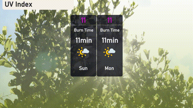
The UV index in Los Angeles is at an extreme level of 11 both on Sunday and Monday, with a very quick burn time of just 11 minutes. With such high UV exposure, it’s crucial to take extra precautions by using sunscreen, wearing hats, and seeking shade frequently.
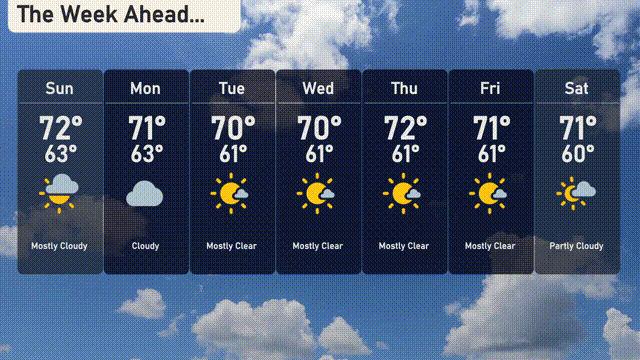
Tuesday: Get ready for mostly clear skies with highs reaching 70 degrees and a comfortable low of 61.
Wednesday: Another day of mostly clear weather, consistent with Tuesday, with a high of 70 degrees and a low around 61 degrees.
Thursday: Look forward to slightly warmer temperatures, with the sun shining brightly and a high of 72 degrees. Expect a low of 61 degrees.
Friday: Mostly clear conditions continue as temperatures reach 71 degrees during the day and dip to 61 at night.
Saturday: Skies will be partly cloudy with highs around 71 degrees and lows at 60 degrees.
Sunday: Mostly clear skies and pleasant temperatures, with the mercury rising to 72 degrees and dropping to 63 as the day ends.
Monday: The week starts with cloudy skies, bringing a high of 71 degrees and a low of 63 degrees.