Navigating the Nuances of Los Angeles Weather: Sunshine, Breeze, and UV Warnings
By
Amy Freeze
From calming mornings to scorching highs, Los Angeles presents a unique tapestry of weather this week. Learn all about tomorrow's forecast and how to prepare for fluctuating temperatures and UV levels.
Gearing up for another week in Los Angeles? Check out our latest weather forecast for tailored insights on what to expect and how to stay comfortable through varying temps and UV levels!
This week in Los Angeles unfolds a story of contrasting weather conditions, from mild mornings to potentially intense UV levels by midday. We cover all the essentials — from the specifics of daily temperatures to strategic tips on handling the Californian sun. This guide ensures you’re well-prepared, whether planning your commutes or outdoor activities.
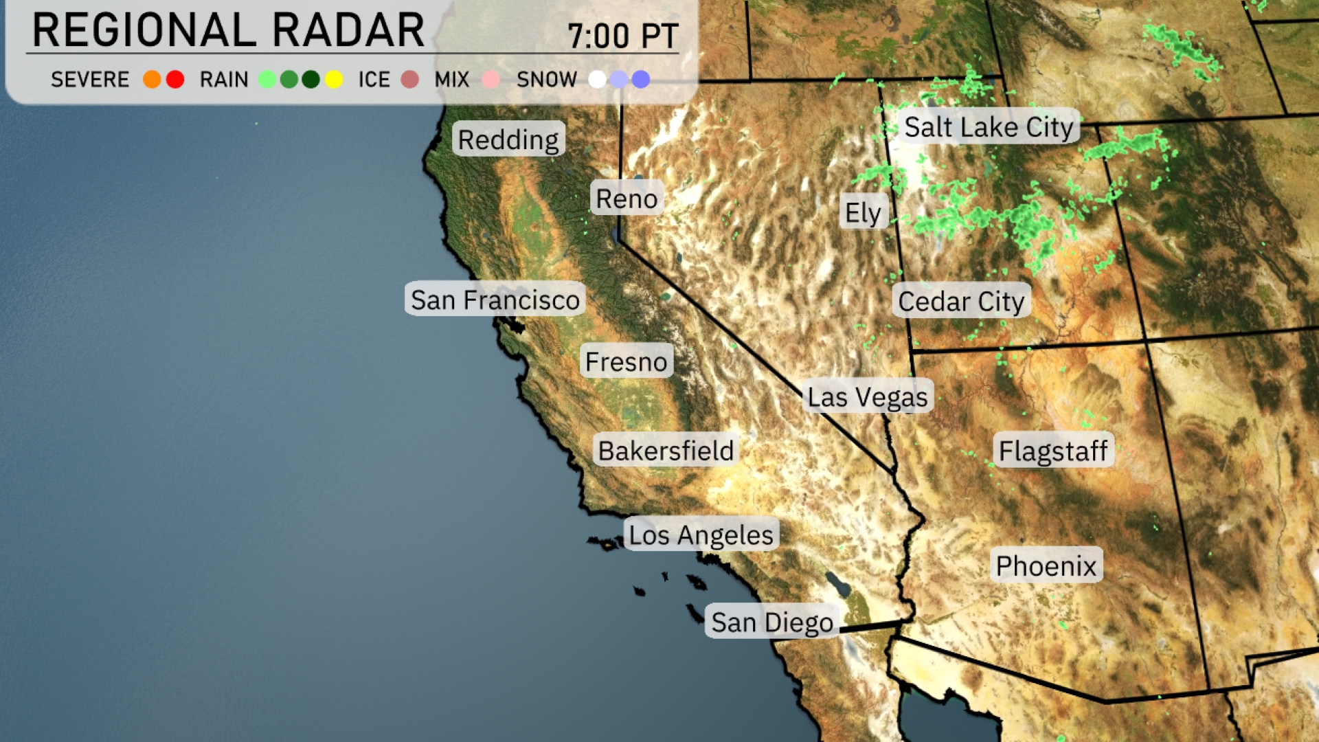
In the Southwest region, monsoon season makes some moves. The regional radar indicates a cluster of rain showers heading over northeastern Nevada, particularly impacting Ely and moving toward Cedar City in Utah. Salt Lake City is experiencing scattered cloud cover, likely leading to brief, mild rain. The coastal areas from San Diego to Los Angeles and San Francisco are currently clear, with no precipitation detected. Flagstaff and Phoenix remain dry, maintaining clear skies tonight.
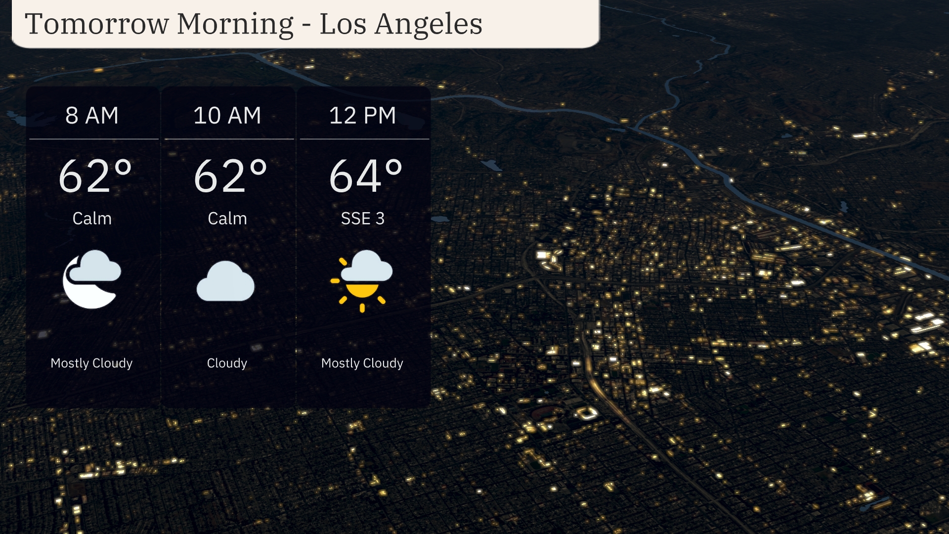
In Los Angeles for tomorrow morning, expect a calm start with temperatures at 62 degrees around 8 AM and 10 AM. Skies will transition from mostly cloudy to cloudy conditions. By noon, there’s a slight southeast breeze at 3 mph and temperatures rising to 64 degrees.
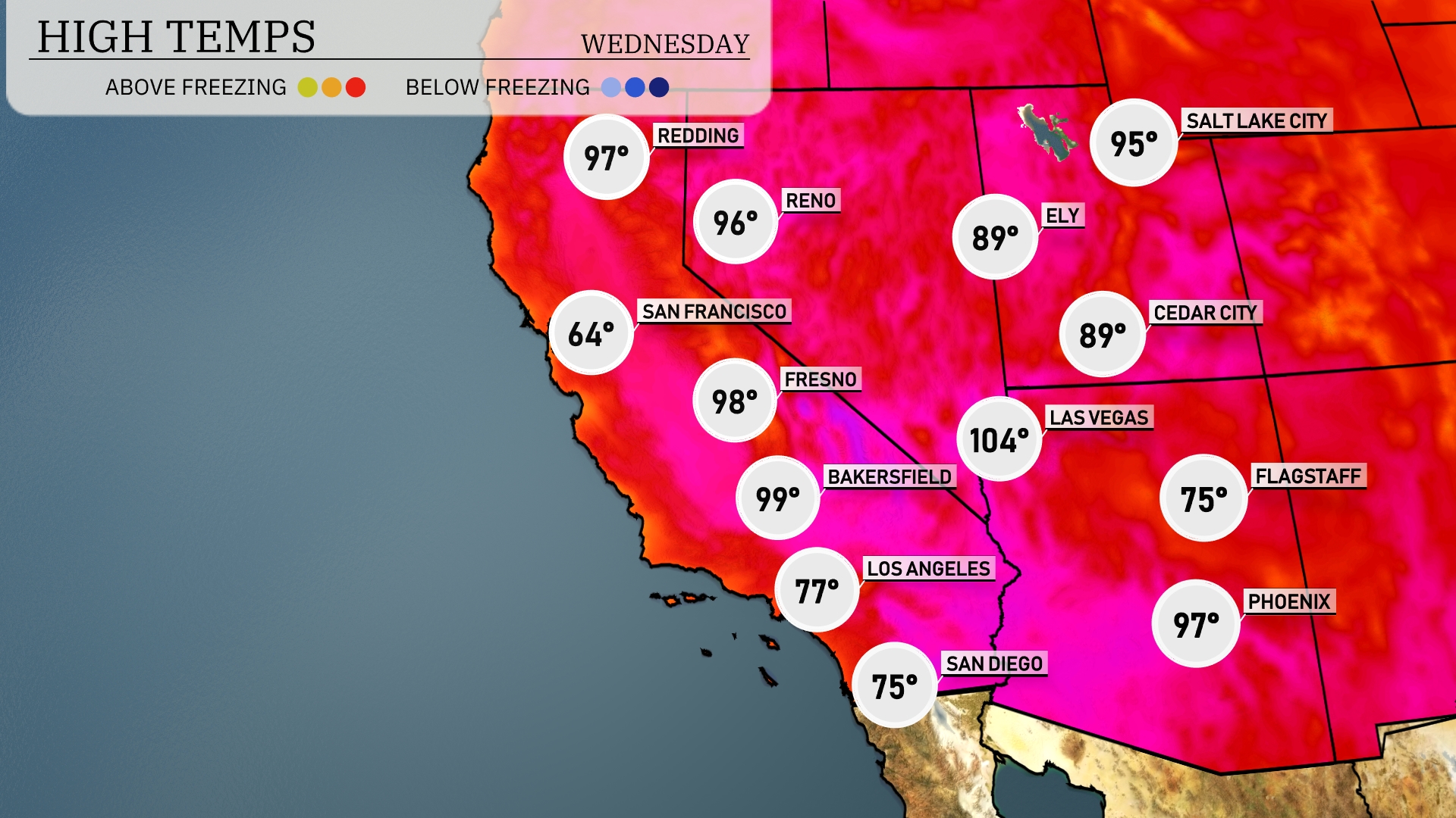
Tomorrow in Las Vegas, expect a scorching high of 104 degrees, continuing a trend of above-average temperatures for the area. Phoenix will also be warm, reaching 97 degrees, while Flagstaff remains cooler at 75 degrees. In California, Bakersfield sees a high of 99, and Fresno will warm up to 98 degrees, both staying above seasonal norms. Los Angeles will have a more moderate day with a high of 77 degrees.
The Southwest is set for a dry and sunny day tomorrow, but northern regions should be prepared for changes. Expect scattered thunderstorms moving through Arizona and New Mexico later in the day, with a chance of heavy rainfall and localized flooding in low-lying areas. A low-pressure system is tracking through Southern California, bringing gusty winds along mountain regions. Temperatures will remain warm, hovering in the 90s across the desert areas.
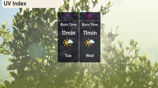
Los Angeles will face very high UV levels of 11 Tuesday and Wednesday, with a quick burn time of just 11 minutes in direct sunlight. Be extra cautious; it’s essential to apply broad-spectrum sunscreen, wear sunglasses, and seek shade often.
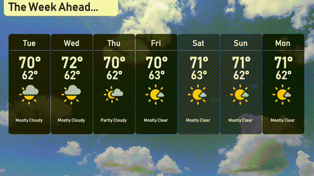
Tuesday: Mostly cloudy skies with a comfortable high of 70 degrees, cooling down to 62 degrees at night.
Wednesday: Anticipate mostly cloudy conditions again, slightly warmer with a high of 72 degrees and a low of 62.
Thursday: Partly cloudy, temperatures will peak at 72 degrees and descend to 62 degrees overnight.
Friday: Expect a bit more sun with mostly clear conditions, as the high reaches 70 degrees and the low is 63.
Saturday: A delightful day with mostly clear skies, high temperatures hitting 71 degrees and a low of 63 degrees.
Sunday: Continuing the trend with mostly clear conditions, a high of 71 degrees and dropping to 62 degrees at night.
Monday: Another mostly clear day, expect temperatures to hold steady with a high of 71 degrees and a low of 62 degrees.