Sunny Days and Stormy Nights: Your Southeast Weather Forecast
By
Amy Freeze
Get the latest updates on weather conditions across Miami and the Southeast. From sunny afternoons to chilly nights and storm warnings, here’s everything you need to stay prepared.
Today in Miami: Enjoy partly cloudy skies with a warm breeze. Watch out for the UV index hitting very high levels! For more details, visit our full forecast.
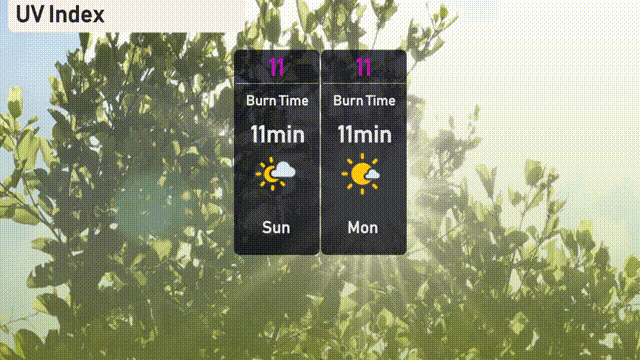
This week in Miami, expect a mix of partly cloudy and sunny days with highs consistently around 87 degrees. As a Southeast storm approaches, prepare for potential scattered showers and thunderstorms affecting not just Miami but extending across Mississippi, Alabama, and Georgia. Don’t forget to watch UV safety with an index of 11 indicating a high risk of sunburn. Stay updated with our daily and weekly forecasts to navigate these changing conditions comfortably.
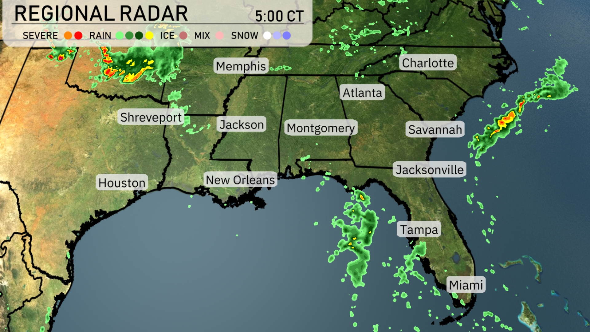
A line of severe storms is making its way into Arkansas from the north, with heavy rain showers trailing just southeast of the line. Scattered showers are present across northern Mississippi, stretching into Tennessee, particularly affecting areas around Memphis. In Georgia, isolated rain showers are forming and moving toward the Carolinas, affecting cities like Atlanta and Charlotte. Florida is experiencing spotty rain showers along the Gulf Coast near Tampa and Miami.
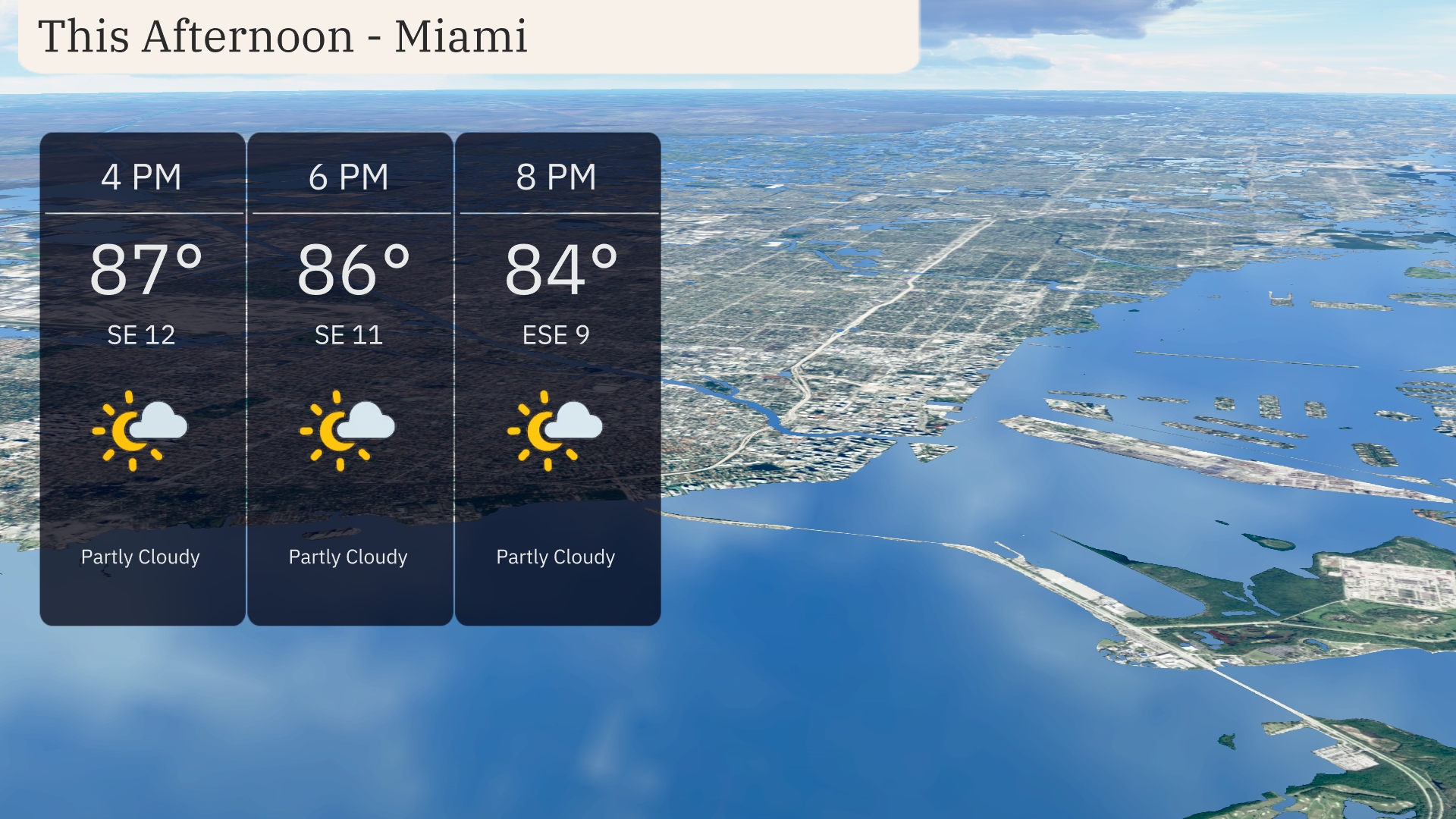
This afternoon in Miami, temperatures are hovering around 87 degrees with a southeast wind at 12 miles per hour at 4 PM. Expect partly cloudy skies as the afternoon progresses. By 6 PM, the temperature will slightly decrease to 86 degrees, with winds continuing from the southeast. At 8 PM, temperatures will cool to 84 degrees with winds shifting to east-southeast at 9 miles per hour.
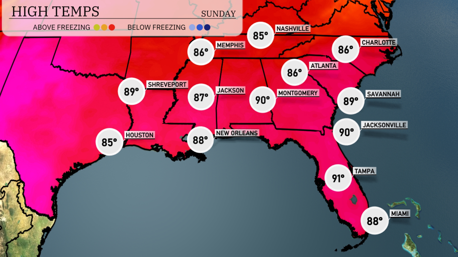
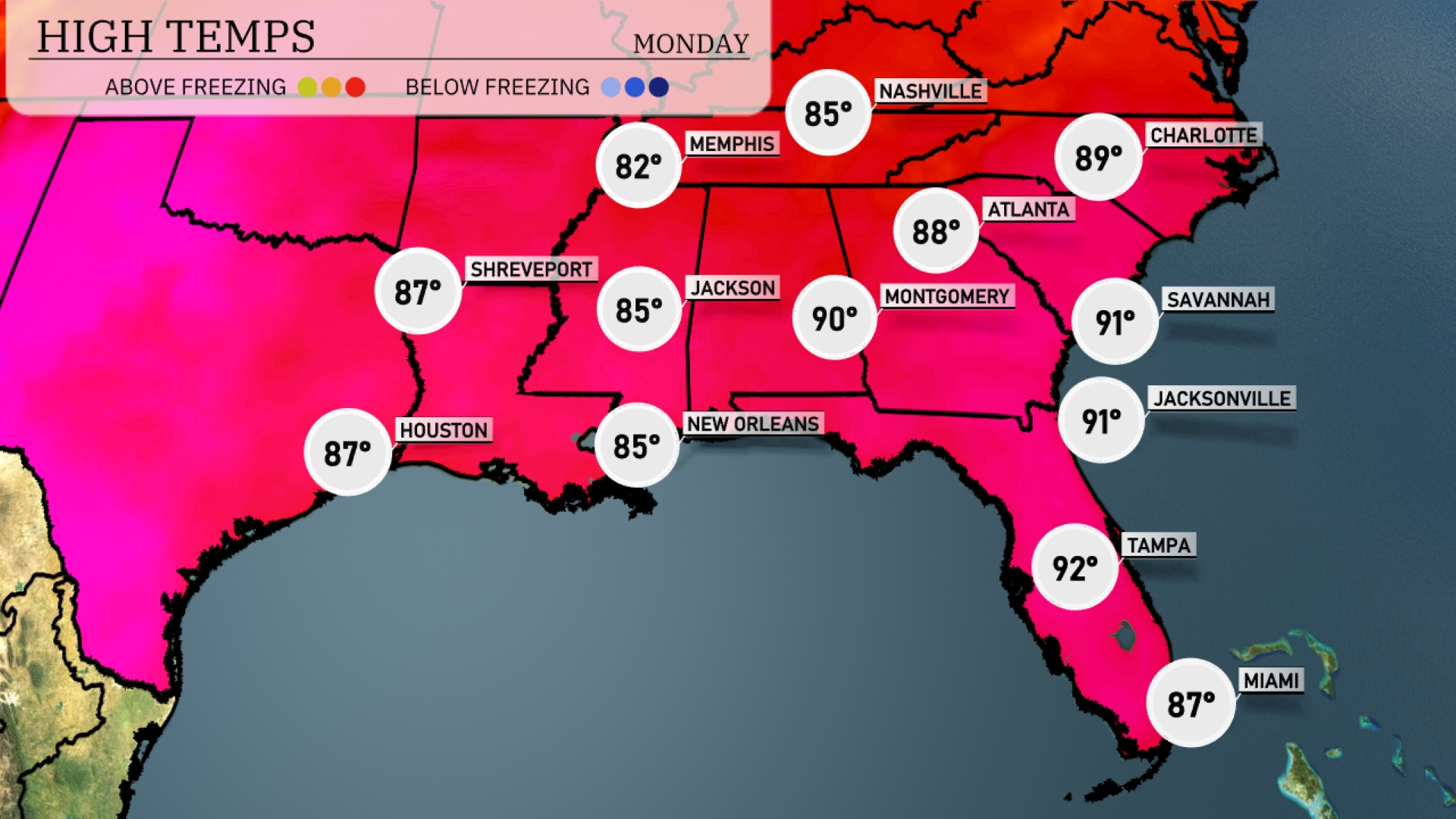
Atlanta reaches a high of 86 degrees, while Montgomery soars to 90. Jacksonville also hits 90, making it one of the hottest spots in the region today. Tampa isn’t far behind, with a high of 91 degrees and plenty of sunshine. New Orleans cools slightly, topping out at 88 degrees.
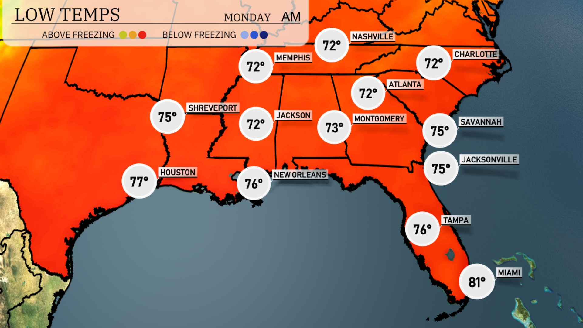
Tonight, Memphis will dip to 72 degrees. Nashville will also experience a low of 72, while Jackson is expected to see 75 degrees. In Savannah, temperatures will fall to 75, and further south, Miami remains warm at 81.
Tomorrow, temperatures in Montgomery will soar to 90 degrees, making it a hot day in central Alabama. Atlanta is anticipating a high of 88 degrees, slightly above the seasonal average, while Charlotte will enjoy 89 degrees as warm air pushes northward. Moving south, New Orleans and Jackson are both projected to reach 85 degrees, keeping things warm and humid. In Florida, Tampa will sizzle with a high of 92 degrees, while Jacksonville and Savannah are expected to hit 91 degrees.
A warm front is pushing through the Southeast, bringing scattered thunderstorms across Mississippi, Alabama, and Georgia through Monday. Watch for heavy rainfall, lightning, and gusty winds particularly from Shreveport to Montgomery, with a potential for flash flooding in low-lying areas. As the system moves east, look for rain chances to increase in Atlanta and Charlotte by evening, tapering off overnight. Behind the front, temperatures will rise slightly ahead of the next wave of storms expected mid-week.
The UV index in Miami on Sunday and Monday is very high at 11, with a burn time of just 11 minutes in direct sunlight.