Miami’s Evening Serenity: Tonight’s Forecast and a Sizzling Week Ahead
By
Amy Freeze
Explore Miami’s calming evening skies and the warm, humid days on the horizon. Get a sneak peek into a week of varied weather conditions from partly cloudy to clear, sunny days.
Tonight, Miami offers partly cloudy skies with temps in the mid-80s. Looking ahead, expect a mix of warmth and storms across the Southeast.
In this update, we delve into the calm of Miami’s evening with slightly cooler temperatures providing a comfortable atmosphere, amidst an otherwise hot Southeastern region. From evening breezes in Miami to expected thunderstorms in nearby areas, we cover all the essentials for your week-long weather preparedness.
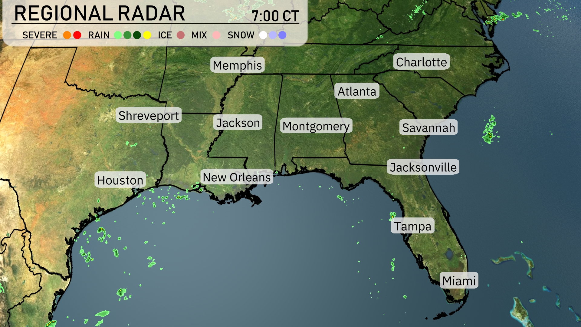
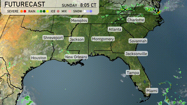
The Southeast region is currently experiencing calm conditions with light showers skirting the Gulf Coast near New Orleans and Houston. Scattered showers are seen off the coast near Miami, adding some moisture to the area. The rest of the region, including cities like Jackson, Atlanta, and Charlotte, remains clear with no immediate precipitation in sight. The radar suggests that these conditions will hold steady for the time being, offering pleasant weather across most of the Southeast.
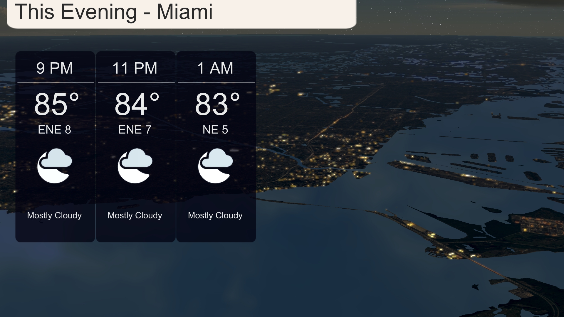
This evening in Miami, temperatures will be quite warm, remaining steady in the mid-80s from 85 degrees at 9 PM to 83 degrees by 1 AM. Expect mostly cloudy skies, which will keep the atmosphere cozy through the night. Winds will be easterly, blowing at 8 to 5 miles per hour, providing a gentle breeze across the city.
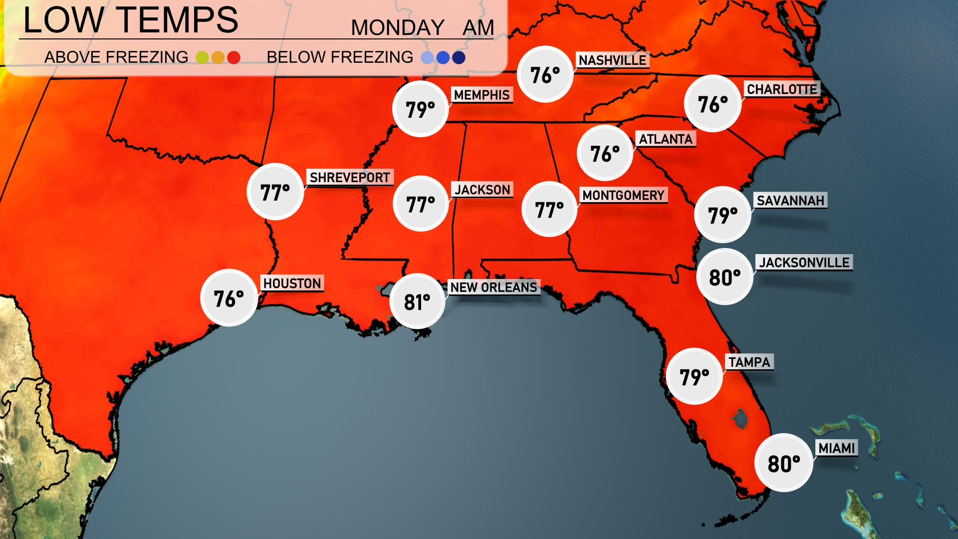
Tonight, Memphis will bottom out at 79 degrees, while Nashville will cool to 76. Expect Jackson to see a low of 77, with Montgomery also at 77 degrees. Tampa and Miami will each maintain warmer overnight temperatures around 79 and 80 degrees, respectively.
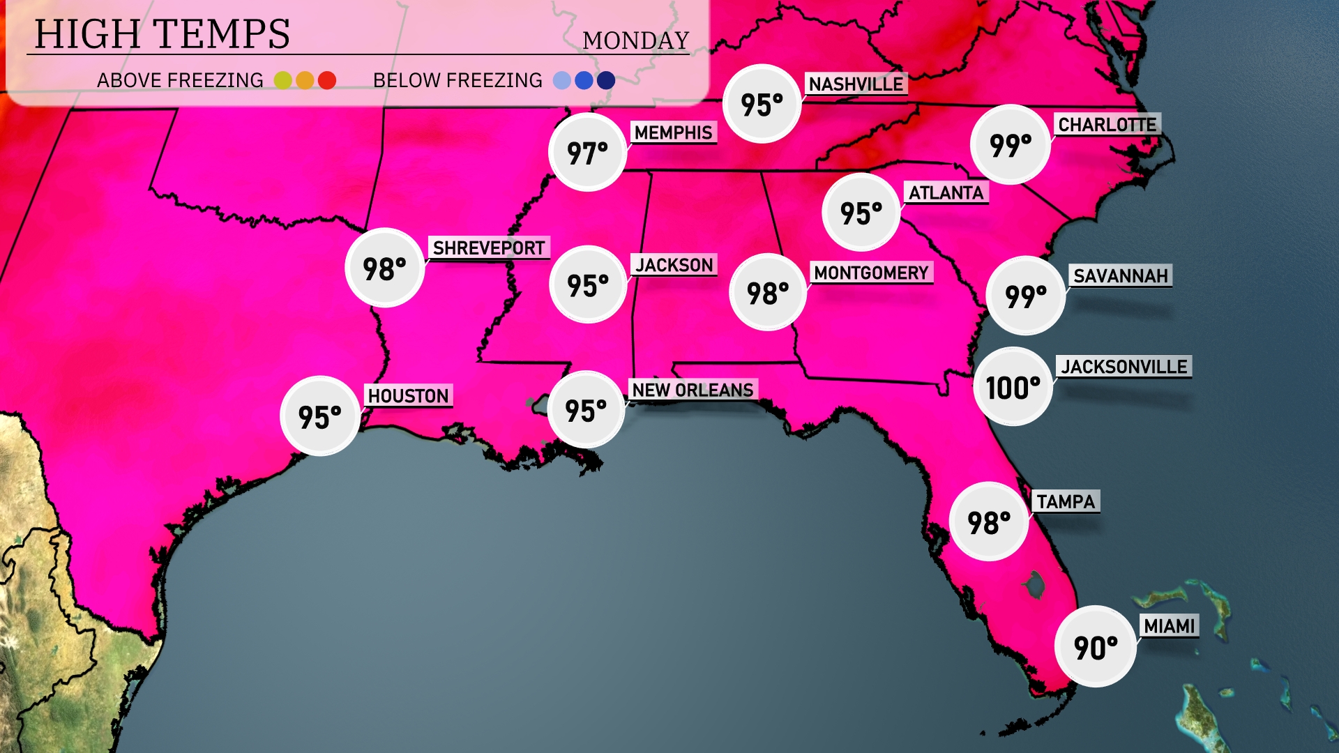
Tomorrow, Jacksonville is set to sizzle with a high of 100 degrees, while Savannah is not far behind at 99 degrees. Atlanta will reach a steamy 95, and Montgomery will see similar temperatures at 98 degrees. New Orleans and Houston both anticipate highs of 95 degrees, which are slightly above the seasonal averages. The Southeast will be influenced by a heat dome, contributing to these elevated temperatures across the region.
Over the Southeast, anticipate a dynamic weather pattern as a cold front approaches. Beginning tomorrow, isolated thunderstorms are possible from Jackson to Montgomery, with the risk of severe storms, including damaging winds and heavy rain, especially near Atlanta. By midday, scattered showers and thunderstorms are expected along the coast from Jacksonville to Savannah. Warm and humid conditions persist with highs in the mid-80s. Watch for localized flooding with continued rainfall through the afternoon.
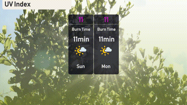
The UV index in Miami is extreme at 11, with a very quick burn time of 11 minutes on both Sunday and Monday. Ensure to wear sunscreen, hats, and sunglasses if heading outdoors. Stay aware and seek shade during peak sun hours!
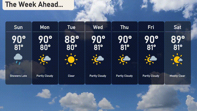
For the 7 Day Outlook in Miami:
Sunday: Showers arriving late with a high of 90 degrees and a low of 80 degrees.
Monday: Partly cloudy skies, temperatures reaching a high of 90 degrees and a low of 81 degrees.
Tuesday: Clear and sunny with a high of 88 degrees and a low of 80 degrees.
Wednesday: Partly cloudy conditions, high of 90 degrees, and an overnight low of 81 degrees.
Thursday: Expect partly cloudy skies with a high of 90 degrees and a low of 81 degrees.
Friday: Another partly cloudy day with a high of 90 degrees and a low of 81 degrees.
Saturday: Mostly clear skies with temperatures reaching a high of 89 degrees and a low of 81 degrees.
Enjoy the week ahead filled with warm weather and occasional sunshine!