Miami Evening Outlook: Warmth, Winds, and Warnings
By
Amy Freeze
Explore the subtleties of Miami's weather from balmy evenings to potential storm warnings. A detailed insight into what’s ahead for the Southeast.
Tonight, Miami braces for mildly cloudy skies with temperatures nicely poised in the low 80s. A calm before potential storms sweeping across Southeastern states.
This blog post provides an in-depth look at the developing weather patterns over Miami and the broader Southeast region. As the warm front from the Gulf introduces severe weather potential to parts of Alabama and Georgia, Miami enjoys comparatively mild conditions. Each day of the upcoming week offers a varied forecast, from partly cloudy tranquility to showers and clear skies. The UV index warning indicates extreme sun exposure risks, suggesting precautions for residents and visitors alike. A comprehensive day-by-day, city-specific breakdown ensures everyone knows exactly what to expect.
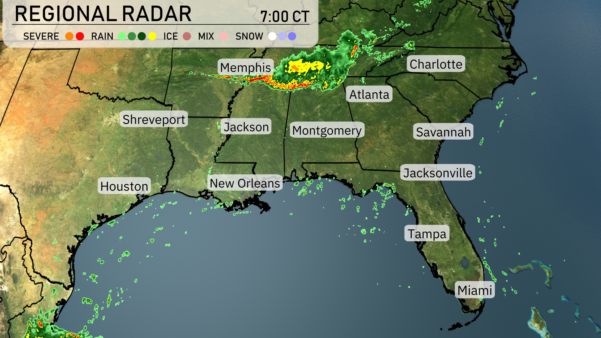
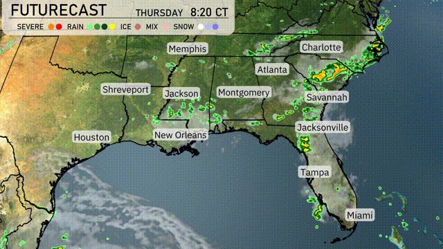
A robust line of storms is sweeping through northern Mississippi and moving towards the Tennessee area, with Memphis experiencing intense activity. Rainy conditions are extending from Montgomery towards Atlanta, where clouds are thickening in anticipation of impending showers. Scattered rain is also visible around Jackson, heading northeast. The Gulf Coast, including places like New Orleans and Tampa, remains clear for now, but keep an eye on shifting conditions.
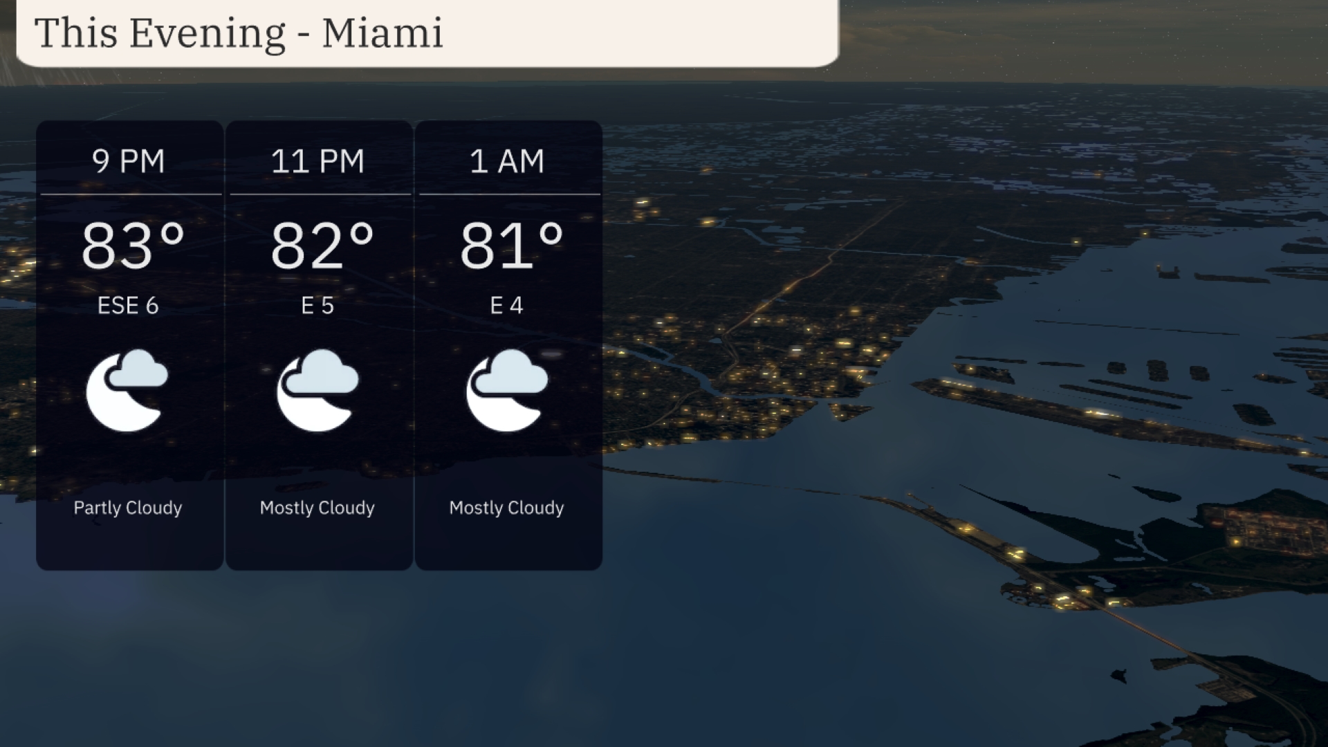
For this evening in Miami, the temperature will remain warm, starting at 83 degrees at 9 PM and gradually cooling to 81 degrees by 1 AM. Expect a steady wind from the east-southeast initially at 6 mph, shifting to east at 4 mph later.
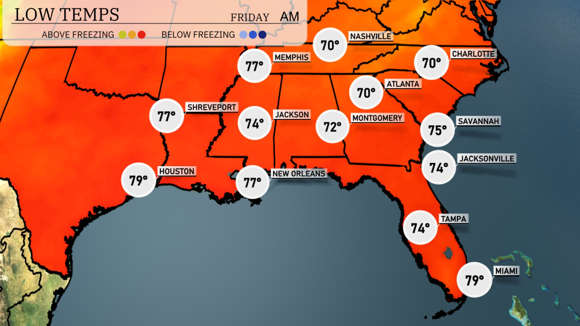
Tonight, temperatures in Memphis will dip to 77 degrees. Nashville will enjoy a mild low of 70, while Atlanta cools down to 70 as well. Expect Jacksonville to settle at 74 degrees and Tampa at 74 as well.
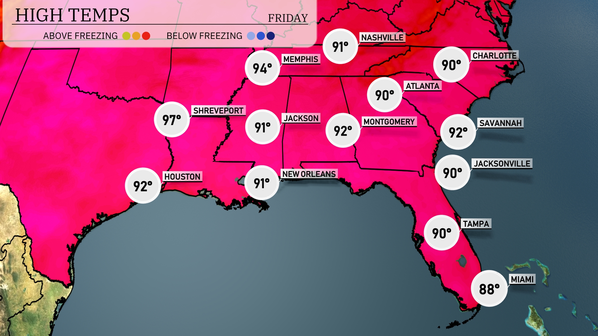
Tomorrow in the Southeast, Shreveport tops out at a sizzling 97 degrees, signaling some of the highest temps in the region. Houston follows closely with a high of 92, while Jackson and New Orleans both reach 91 degrees. Atlanta and Montgomery will see highs around 90 degrees, indicative of average summer warmth. Meanwhile, Miami is slightly cooler, peaking at 88 degrees, reflecting the ongoing influence of coastal breezes. Expect a warm and humid day throughout, with many areas experiencing temperatures above seasonal averages.
A warm front is entering from the Gulf, causing widespread storms from New Orleans to Jacksonville by midday. Expect heavy rain and possible localized flooding along the Gulf Coast, with a risk of severe thunderstorms in parts of central Alabama and Georgia. Charlotte might see scattered showers late tomorrow evening as the system progresses northeastward. Be on alert for potential tornado watches across Alabama due to heightened instability.
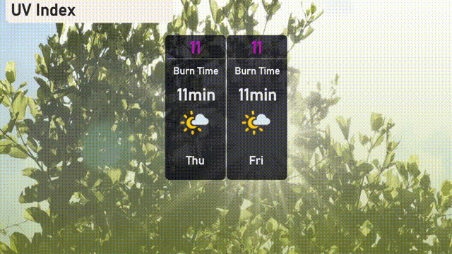
The UV index in Miami will be extreme over the next couple of days with a value of 11, meaning sun exposure can lead to burns in about 11 minutes.
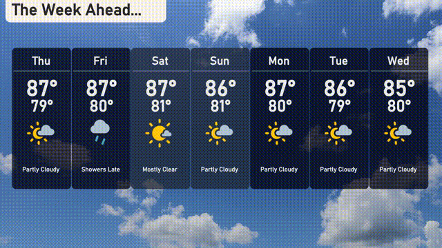
For the 7-day outlook in Miami:
Thursday: Partly cloudy with a high of 87 degrees and a low of 79 degrees.
Friday: Showers expected late, with a high of 87 degrees and a low of 80 degrees.
Saturday: Mostly clear skies with temperatures reaching a high of 87 degrees, cooling to a low of 81 degrees.
Sunday: Partly cloudy with daytime temperatures peaking at 86 degrees and a low of 81 degrees.
Monday: Another partly cloudy day, highs are around 87 degrees and lows of 80 degrees.
Tuesday: Partly cloudy skies with a high of 86 degrees and a low of 79 degrees.
Wednesday: Enjoy partly cloudy conditions with temperatures reaching up to 85 degrees and a low of 80 degrees.