Miami Evenings: A Breezy Blend of Clouds and Warmth
By
Amy Freeze
Explore our evening weather forecast for Miami and the Southeast, with insights on thunderstorms and temperature trends across the region.
Tonight in Miami, expect partly cloudy skies with temperatures holding steady at 84°F. A look at the broader Southeast shows thunderstorms moving through and temperature dips across multiple cities.
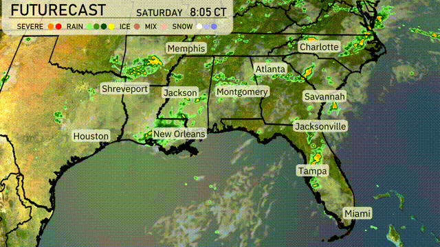
This evening in Miami, the weather continues to be mild with temperatures at a comfortable 84 degrees, under partly cloudy skies. Meanwhile, the evening is heating up across the Southeast. Thunderstorms are brewing across northern Mississippi, bringing intense weather to Memphis, while scattered showers approach coastal Texas and the Florida panhandle. Amid these developments, cities like New Orleans and Atlanta enjoy lighter conditions. Tomorrow anticipates a cold front with potential travel disruptions due to heavy rain. For a full 7-day Miami forecast and more on the Southeast’s weather, visit our detailed blog post.
A line of thunderstorms is moving through northern Mississippi heading towards Memphis, where intense weather is anticipated. Scattered showers are forming along the coastal areas of Texas, near Houston, and near the Florida panhandle, moving northwards. Light rain is occurring in New Orleans and moving towards the Gulf Coast. Across the Southeast, from Atlanta to Charlotte, skies are clearer, giving way to breezy, comfortable weather.
Temperatures in Miami this evening remain steady at 84 degrees through 11 PM, dropping slightly to 83 degrees by 1 AM. Expect an easterly breeze with winds reaching 9 miles per hour, providing a gentle cooling effect. Partly cloudy skies will dominate the evening, adding some texture to the night sky.
Tonight, Memphis will dip to 73 degrees, while Nashville is forecasted to reach a low of 71. In Jackson, temperatures will fall to 70 degrees, with Montgomery expecting a low of 72. Atlanta is also forecasted at 71, and the coastal cities like Savannah and Jacksonville will see lows around 75 degrees.
Tomorrow, Atlanta will reach a high of 88 degrees, while Montgomery will be slightly cooler at 87. Jacksonville is set to hit 89 degrees, with Tampa peaking at 91, marking the warmest spot in the Southeast. New Orleans and Jackson are both expected to have highs around 86 degrees.
A cold front advances across the Southeast with thunderstorms moving from Louisiana to Georgia by tomorrow. Expect periods of heavy rain and gusty winds, with localized flooding in low-lying areas. In the early morning, storms are expected around New Orleans, progressing eastward toward Atlanta by afternoon. Rainfall could exceed two inches in some spots, creating travel disruptions.
The UV index in Miami is very high at 11 over the weekend, indicating a burn time of about 11 minutes under direct sunlight. Make sure to apply a broad-spectrum sunscreen, wear protective clothing, and seek shade during peak sun hours.
For the 7-day forecast in Miami:
Saturday: A delightful day with partly cloudy skies. Expect a high of 87 degrees and a low of 81 degrees.
Sunday: Continuation of the partly cloudy weather with a high of 87 degrees, dipping to 81 degrees at night.
Monday: Mostly clear skies welcome a high of 87 degrees and a comfortable low of 81 degrees.
Tuesday: Keep enjoying the mostly clear conditions, sustaining a high of 87 degrees and a low of 81 degrees.
Wednesday: Partly cloudy once again. Temperatures stay consistent with a high of 87 degrees and a low of 80 degrees.
Thursday: More partly cloudy conditions expected, with a high of 87 degrees and a low of 80 degrees.
Friday: Wrap up the week with partly cloudy skies, reaching a high of 87 degrees and a night low of 81.