The Ever-Changing Skies of Miami: A Weather Update from Amy Freeze
By
Amy Freeze
Expect partly cloudy evenings, regional showers, and the details on the upcoming severe weather threats. A comprehensive update on what to wear and what to expect outdoors in Miami and surrounding areas.
Navigating through Miami’s weather can be tricky. Stay prepared with our latest Southeast weather insights, with a detailed forecast for Miami.
As the sun sets over Miami, partially cloudy skies and pleasant temperatures create the perfect evening backdrop. But beyond our windows, the Southeast brims with weather activity. From showers in Alabama to thunderstorms in Jacksonville, we’ve got a detailed breakdown of everything the weather has to offer. Stay tuned, and always be weather-prepared!
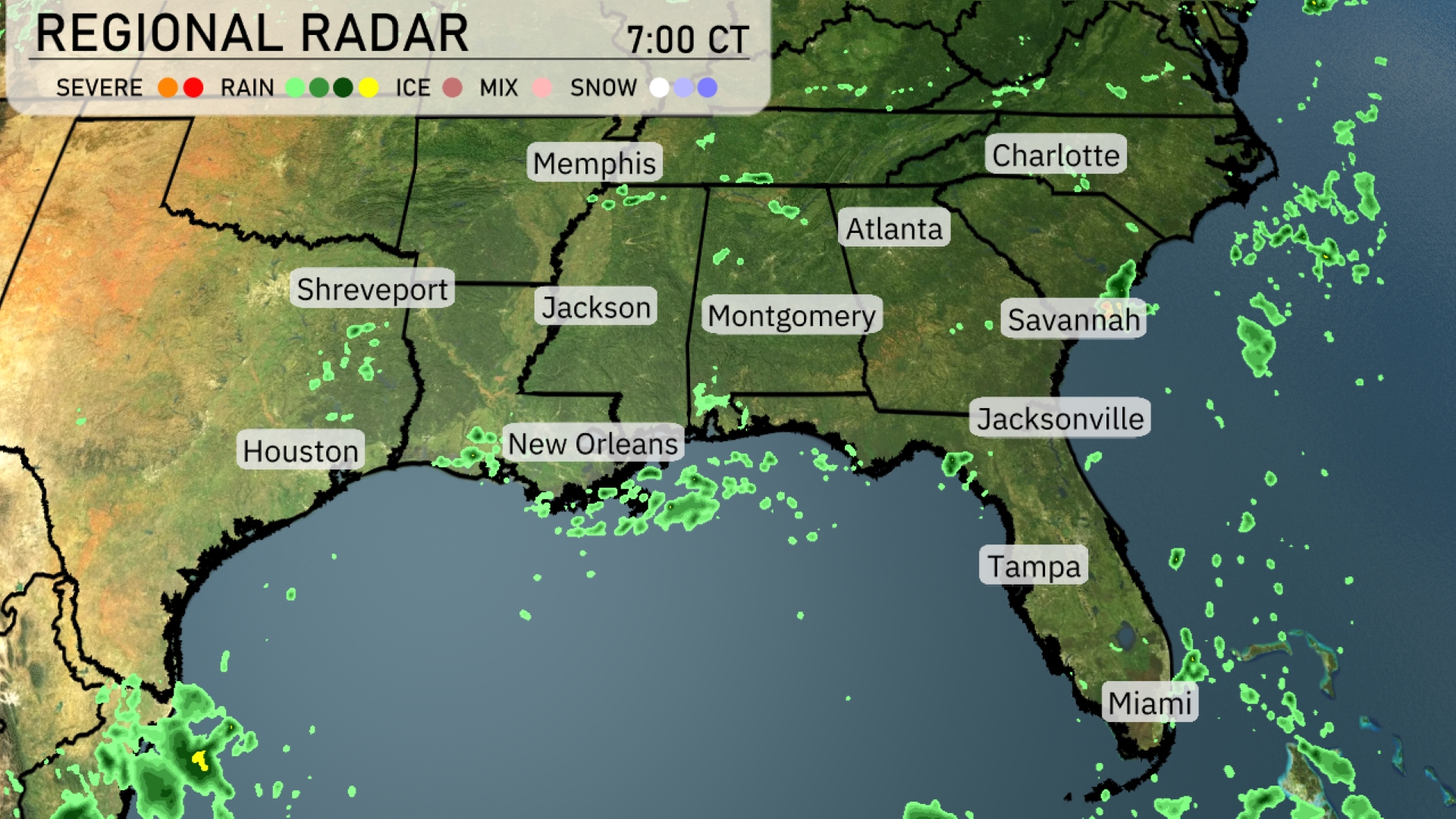
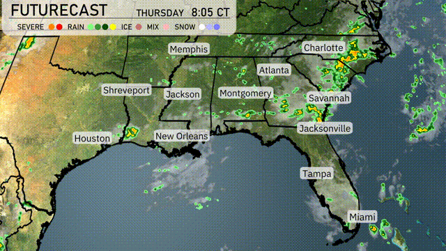
On the regional radar, scattered showers extend across Southern Mississippi into New Orleans, with more patches moving across southern Georgia towards the Atlantic Coast. Rain showers are sweeping through Alabama and up into Montgomery, gradually advancing eastward towards Atlanta. Savannas and Jacksonville are also experiencing some rain, suggesting umbrellas might be needed today. The Carolinas, including Charlotte, are clear for now, but increasing clouds suggest potential changes later on.
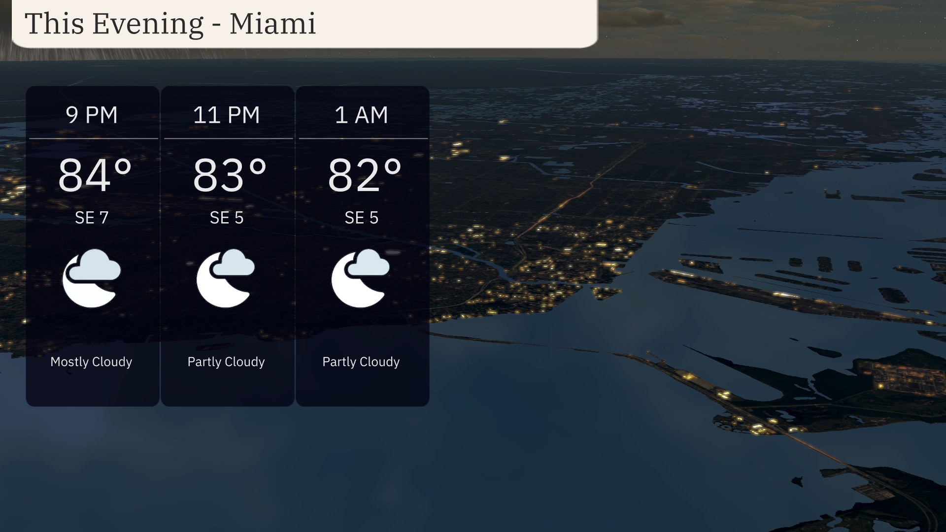
Evening temperatures in Miami will start at 84 degrees at 9 PM and gradually decrease to 82 degrees by 1 AM. Expect winds shifting from southeast at 7 miles per hour to 5 miles per hour. Cloud cover reduces slightly from mostly cloudy to partly cloudy as the night progresses.
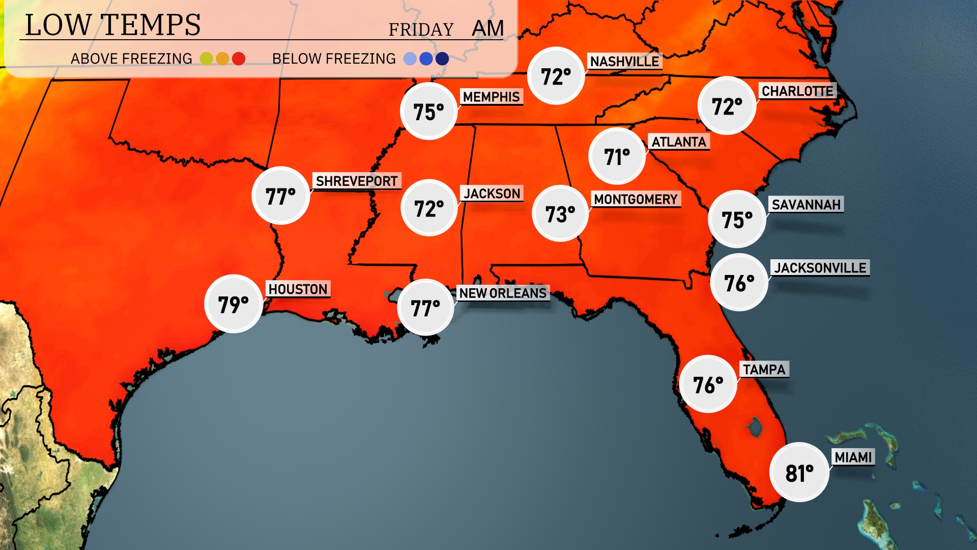
Tonight, temperatures in the Southeast will remain warm, but some areas will start to feel a dip. Memphis is expected to cool down to 72 degrees, while Nashville will drop slightly to 71. In Alabama, Montgomery will experience a low of 73 degrees. Meanwhile, Tampa will see a mild low of 76 degrees, and Miami will be warmer at 81 degrees.
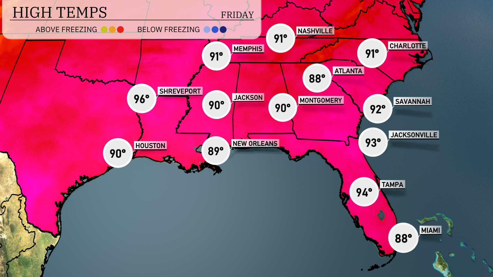
Tomorrow, high temperatures will soar in the Southeast, with Shreveport reaching 96 degrees. Houston is looking at a warm 90 degrees, while Memphis and Nashville expect highs of 91. In the central regions, Jackson and Montgomery will also see 90 degrees. Meanwhile, coastal areas like Jacksonville and Tampa are set for balmy highs of 93 and 94 degrees, respectively, contributing to above-average readings across the board due to a strong high-pressure system in place.
A cold front is set to push through the Southeast tomorrow, beginning in the early morning. Expect a band of showers and thunderstorms moving from the Gulf Coast through to the Carolinas. Atlanta and Montgomery should brace for potential severe weather, including strong winds and heavy rainfall, during the morning commute. Cities like Savannah and Jacksonville will experience more intense thunderstorms by midday. Rainfall could be heavy at times, with the possibility of localized flooding due to the saturated ground.
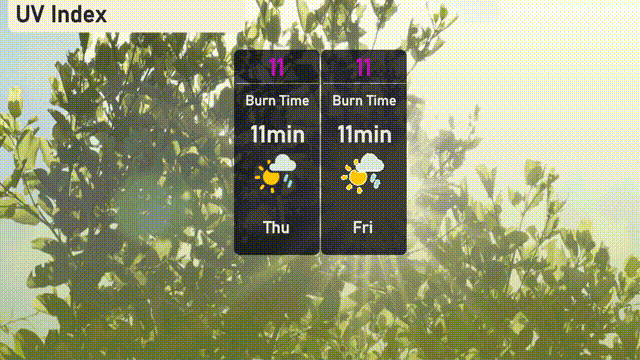
Miami’s UV index will be extreme over the next few days, with a value of 11 on both Thursday and Friday, indicating a burn time of just 11 minutes under direct sunlight. Extreme caution is advised—apply broad-spectrum sunscreen liberally, wear hats, and use sunglasses to reduce risk. Remember, sun protection is essential even with some cloud coverage.
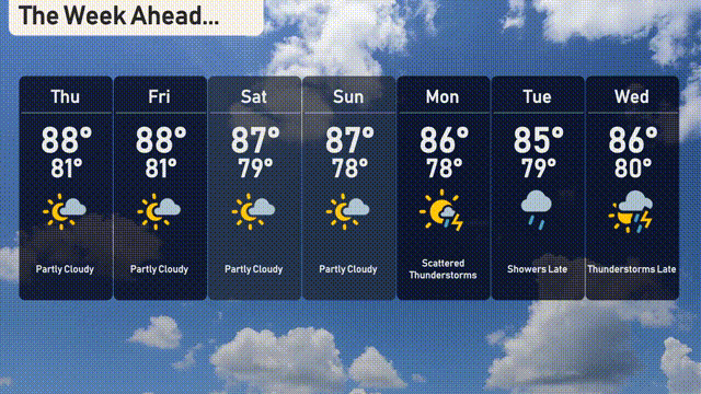
Thursday: Look for partly cloudy skies with a high near 88 degrees and a low of 81 degrees.
Friday: Similar day today, continuing partly cloudy with temperatures peaking at 88 degrees and dipping to 81 degrees at night.
Saturday: Mainly cloudy with some sun peeking through. Expect a high of 87 degrees and a low of 79 degrees.
Sunday: Partly cloudy with a high around 87 degrees and a low of 78.
Monday: Get ready for scattered thunderstorms, with highs reaching 86 degrees and lows around 78.
Tuesday: Showers are expected later in the day, with a high of 85 degrees and a low of 79.
Wednesday: Thunderstorms return late, with temperatures climbing to 86 degrees and a low of 80 degrees.
Stay prepared and enjoy your week ahead in Miami!