Miami Evening Weather: From Steamy Days to Stormy Nights
By
Amy Freeze
Explore our comprehensive Southeast weather report detailing Miami's cloudy evenings, impending thunderstorms, and temperature shifts across the region.
Tonight, Miami faces partly cloudy skies with consistent temperatures. The broader Southeast prepares for rain and possible severe weather. Stay updated and safe!
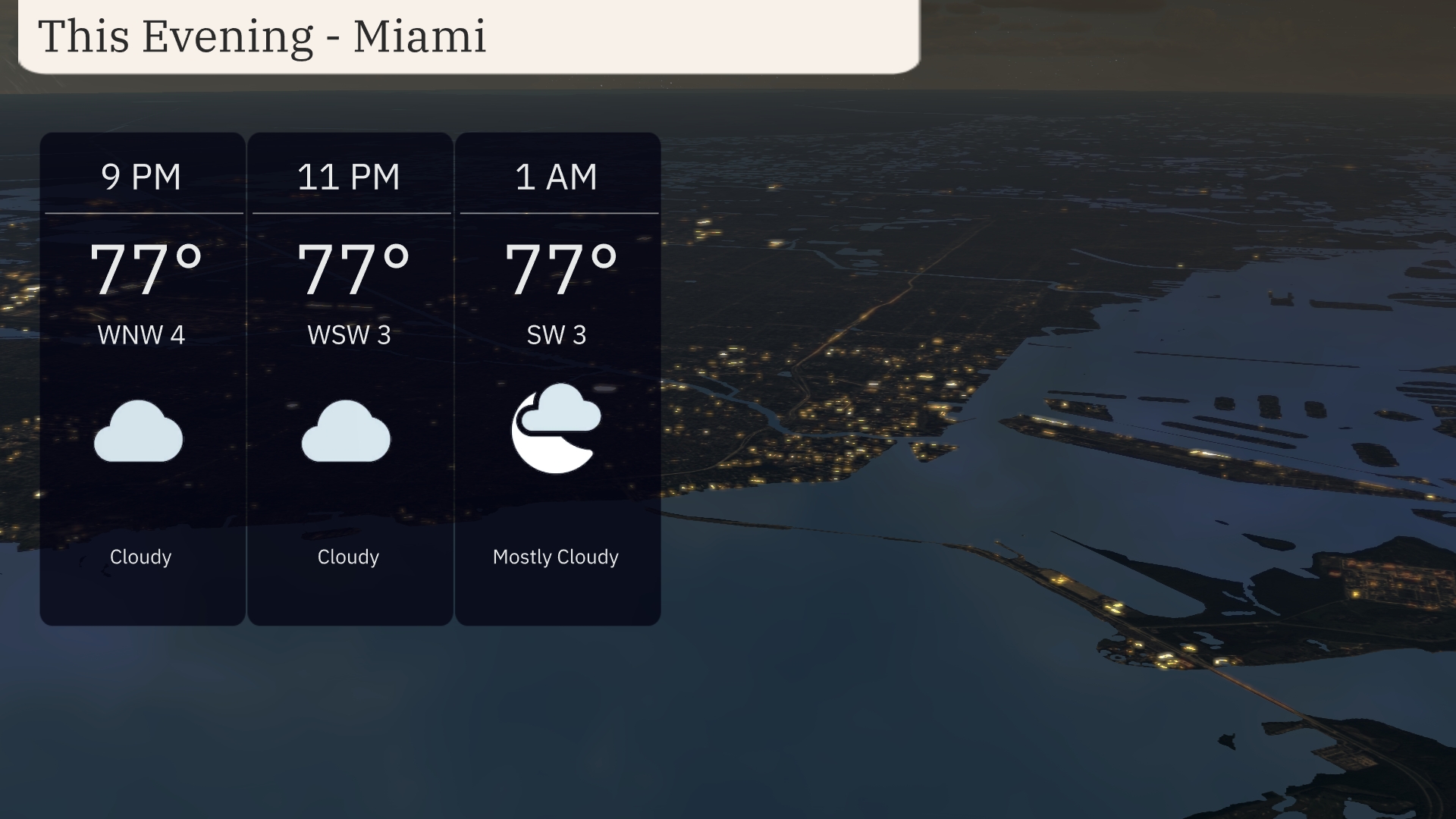
This evening, Miami will experience partly cloudy conditions with temperatures around 77°F. Across the Southeast, from Houston to Jacksonville, the weather is heating up, heralding a series of afternoon thunderstorms and significant temperature drops post-storm. Explore detailed forecasts and safety advisories for your area as we cover everything from UV indexes to nighttime lows throughout the week.
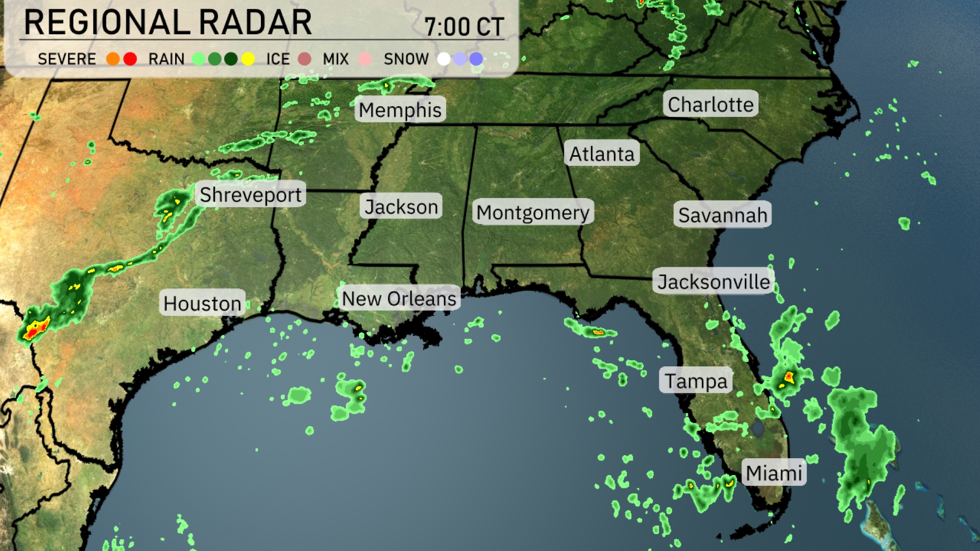
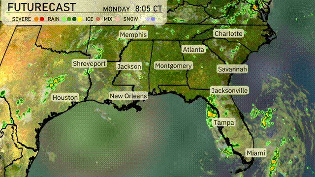
A line of thunderstorms is advancing eastward, just west of Shreveport, moving towards Jackson with the potential for severe weather. Meanwhile, scattered showers are continuing to pop up near Houston and across the Florida Peninsula, from Jacksonville down to Miami. The clear skies above Atlanta make it a dry morning, while New Orleans can expect rain to begin later as approaching clouds gather. Lastly, areas near Savannah and Charlotte are currently free of rain, but cloud cover is building as a weather system approaches from the west.
This evening in Miami, anticipate temperatures staying steady at 77 degrees from 9 PM through 1 AM. Winds will shift from west-northwest at 4 mph early in the evening to southwest at 3 mph by late night. The sky will remain cloudy, transitioning to mostly cloudy by 1 AM. Keep this consistent cloud cover in mind if you’re planning an evening stroll.
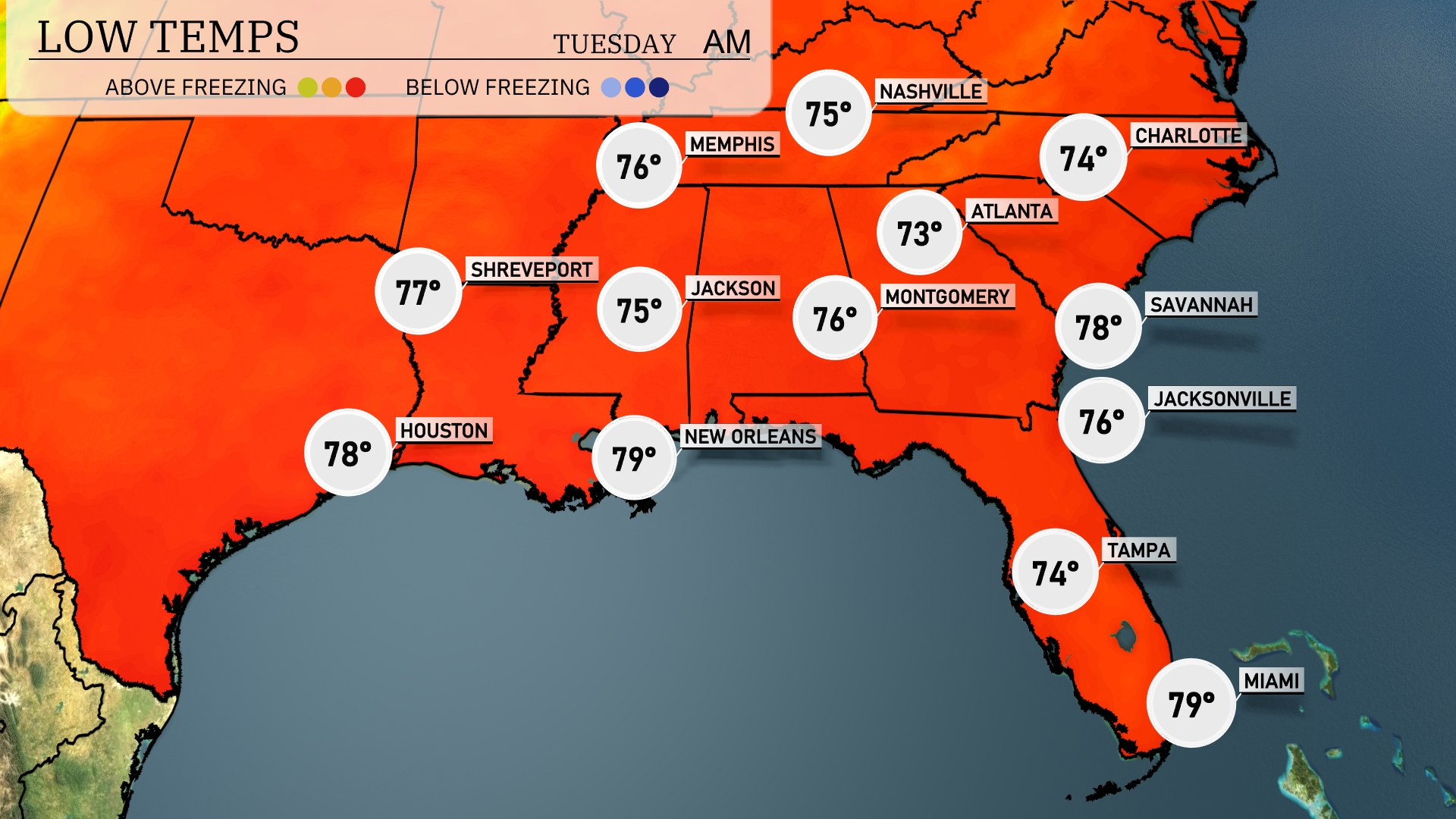
Tonight, Memphis will cool down to 75 degrees, while Nashville dips slightly to 74. In Atlanta, expect a low of 73, with Montgomery forecasted at 76. Jacksonville will hit a low of 76, while further south, Tampa will experience a mild night with a low of 74. New Orleans remains warm at 79 degrees.
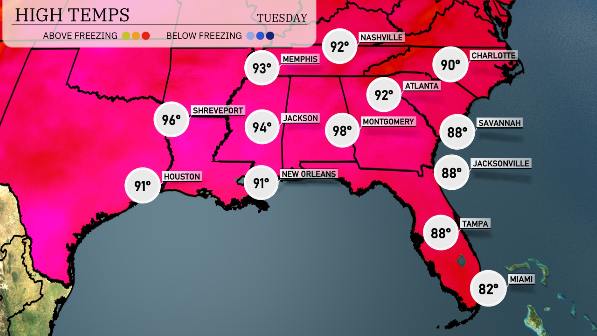
Tomorrow, Montgomery will see a sweltering high of 98 degrees, making it one of the hottest spots in the Southeast. Jackson is also warming up nicely, with a high of 94 degrees expected. In New Orleans, temperatures will reach 91 degrees, while Houston enjoys a high of 91 as well. Further east, Atlanta and Nashville will both hit around 92 degrees, keeping temperatures consistently above average across the region. Notably, coastal areas like Jacksonville and Savannah will be cooler but still warm, with highs of 88 degrees.
The Southeast will experience a dynamic weather shift tomorrow as a cold front moves in from the west. Expect rain showers to spread from Houston to Shreveport and into Jackson by midday. Thunderstorms are likely in New Orleans and Montgomery, potentially bringing gusty winds and heavy rain. As the front progresses, the threat of severe weather, including damaging winds, will rise, particularly in the late afternoon for areas like Atlanta and Charlotte. Post-storm, expect a drop in temperatures by Thursday, with drier conditions prevailing.
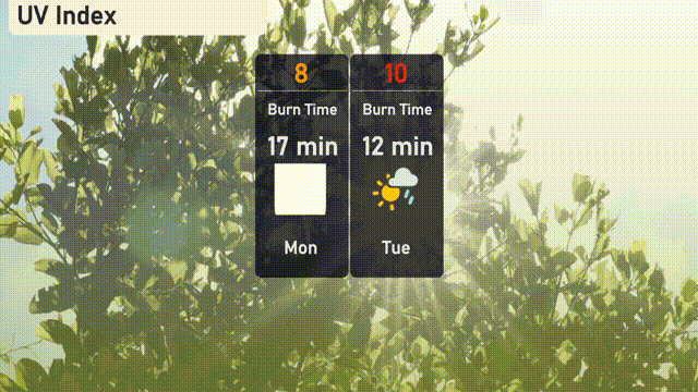
The UV index in Miami is expected to reach a high of 8 on Monday, with a burn time of approximately 17 minutes under direct sunlight. On Tuesday, the index jumps to a very high level of 10, reducing burn time to just 12 minutes, so make sure to take extra precautions. Consider using sunscreen and seeking shade during peak sun hours!
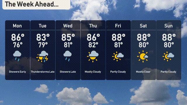
Monday: Showers early with a high of 86 degrees and a low of 76 degrees.
Tuesday: Watch for thunderstorms with a high of 83 degrees and a low of 79 degrees.
Wednesday: Expect showers late, peaking at 85 degrees during the day and 81 degrees at night.
Thursday: Mostly cloudy with temperatures reaching 86 degrees and a low of 82 degrees.
Friday: Partly cloudy skies with a day high of 88 degrees and a night low of 81 degrees.
Saturday: Mostly clear and warm with a high of 88 degrees and a nighttime low of 80 degrees.
Sunday: Partly cloudy conditions with temperatures holding steady at 88 degrees and a low of 80 degrees.
Stay safe and enjoy the week ahead!