Weather Wonders: Miami’s Clear Skies Lead the Southeast Parade
By
Amy Freeze
Meteorologist Amy Freeze shares insights on the balmy evenings and the storm systems shaping weather across the Southeast, from Miami to Houston.
Experience the beauty of Miami’s evening with perfect weather for a beach stroll! Dive deeper into the weather dynamics affecting the Southeast.
Good evening Miami residents and visitors! Meteorologist Amy Freeze here with a detailed look at your local weather and the broader Southeast region’s conditions. Tonight in Miami, enjoy pleasant temperatures perfect for evening plans under partly cloudy skies. However, not too far from here, the weather tells a different story with a robust storm system moving eastward, impacting places from Houston to Jacksonville. Stay tuned for updates and useful tips to navigate these changes!
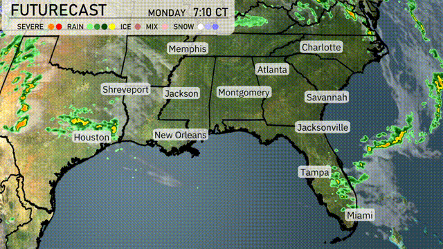
The regional radar shows a robust storm system advancing eastward, with severe weather approaching Houston, indicated by the yellow shading. Showers are extending up towards Shreveport, while rain is blanketing areas around Jackson. Clear conditions are present from New Orleans to Montgomery, providing a brief respite. Rainfall is expected to make its way towards Atlanta, with Jackson experiencing some heavier showers on the move. Coastal locations such as Savannah and Jacksonville are currently clear, though cloud cover associated with an offshore system looks set to approach.
In Miami this evening, temperatures will stay consistent, hovering around 78 degrees at 9 PM and slightly decreasing to 77 degrees by 11 PM. The wind will be gentle from the east-southeast at 6 miles per hour, offering a breezy touch to the night. Expect partly cloudy skies to provide a pleasant backdrop.
Tonight Memphis will cool down to 56 degrees, while Nashville dips to a brisk 58. Atlanta sees a low of 61, and Montgomery will be slightly cooler at 61 as well. In contrast, farther south, temperatures remain mild, with lows of 71 in Jacksonville and 72 in Tampa. Charleston rounds out the region with an overnight low of 55.
Tomorrow Atlanta will reach 79 degrees, while Montgomery is set to hit 82. Notably, Jacksonville will soar to 90 degrees, and Savannah will warm up to 86. Miami is also in for a balmy day with temperatures peaking at 84 degrees. The warm weather is largely influenced by a developing high-pressure system bringing dry and stable air to the region.
A stationary front drapes across the Southeast, promising a soggy Tuesday with showers spreading from Houston to Jacksonville. Expect heavy rainfall along the Gulf Coast with potential localized flooding in New Orleans and Mobile. Thunderstorms develop in the afternoon, packing strong winds from Jackson to Birmingham. Temperatures remain warm, pushing near 80°F in Atlanta, but cooler air lingers behind the front across Texas. By late Tuesday, skies clear slightly in Dallas, yet unsettled conditions persist eastward into Wednesday.
The UV index in Miami for Monday and Tuesday is extremely high at 11, with a burn time of just 11 minutes in direct sunlight. Be extra cautious as you plan your outdoor activities, and ensure you have adequate sun protection.
For the 7-day forecast in Miami:
Monday: Partly cloudy with a high of 83 degrees and a low of 76.
Tuesday: Another partly cloudy day with temperatures climbing to 84 degrees, the low remains at 76.
Wednesday: Enjoy partly cloudy skies, once again with a high of 84 degrees and a low of 75.
Thursday: Mostly clear skies, temps reach up to 85 degrees during the day and 75 at night.
Friday: Partly sunny with a high of 85 degrees, the night brings cooler temperatures at 76.
Saturday: Expect partly cloudy conditions with highs around 83 degrees and lows at 76.
Sunday: Scattered thunderstorms are in the forecast, the high drops to 82 degrees, with a low of 74.