Miami Forecast: Morning Clarity with Rising Temperatures
By
Amy Freeze
Partly cloudy and warm in Miami while storms shake up the Southeast. Here's what the week has in store for us.
Wake up to Miami’s weather: partly cloudy with temperatures rising to an enjoyable 89°F by midday. Plus, get the full scoop on Southeast’s shifting weather patterns.
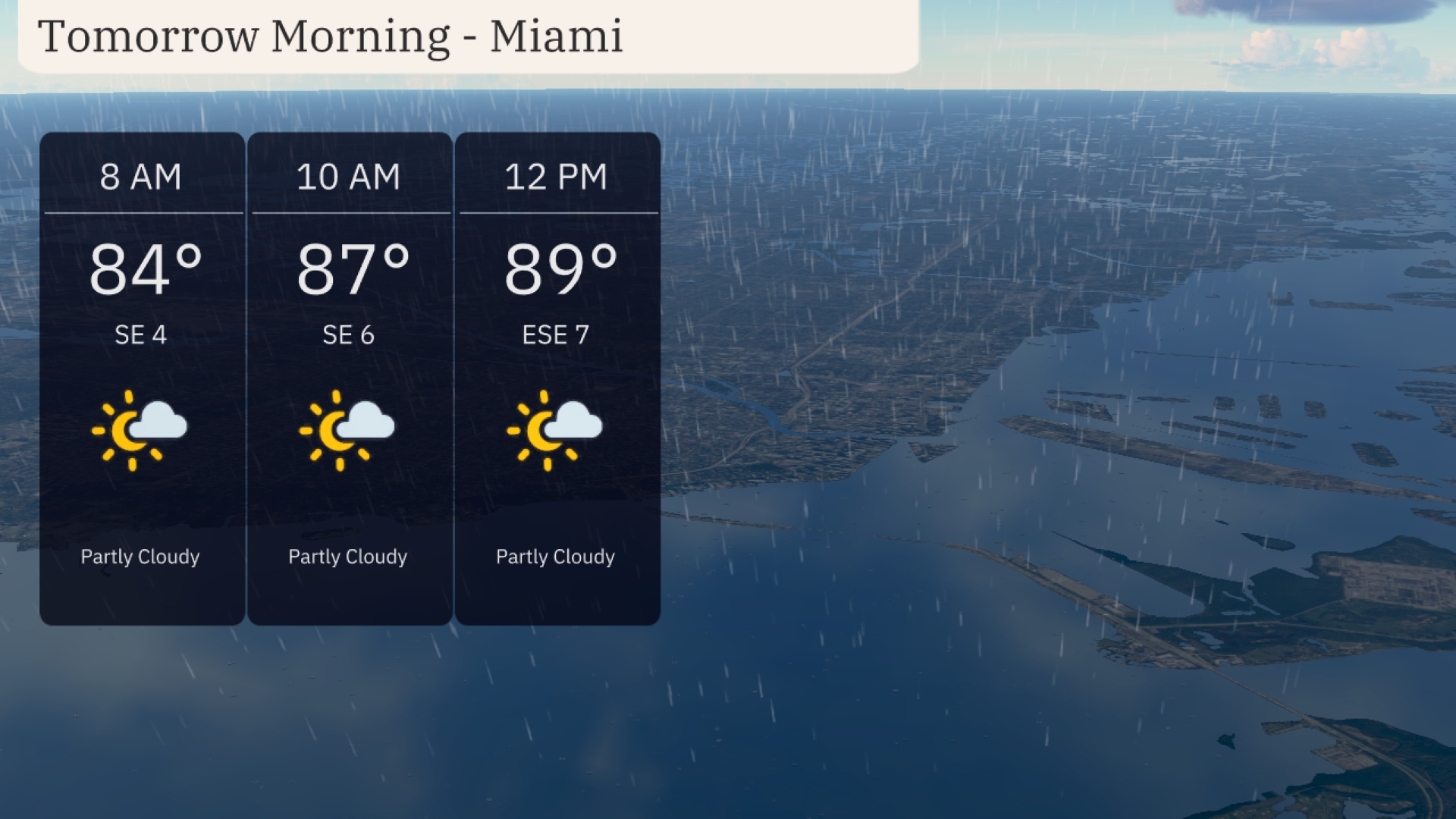
Welcome to your Miami morning forecast! Start your day with the warmth as temperatures hit 84 degrees under partly cloudy skies. Through the day, expect a mild climb to 89 degrees, complimented by a soft southeast breeze. Alongside Miami’s relatively clearer skies, a broader perspective on the Southeast reveals potential storms and varied temperatures, emphasizing the diverse climatic conditions within the region. Dive deeper into individual forecasts for nearby areas like Jacksonville, Shreveport, and more extensively covered in our full report.
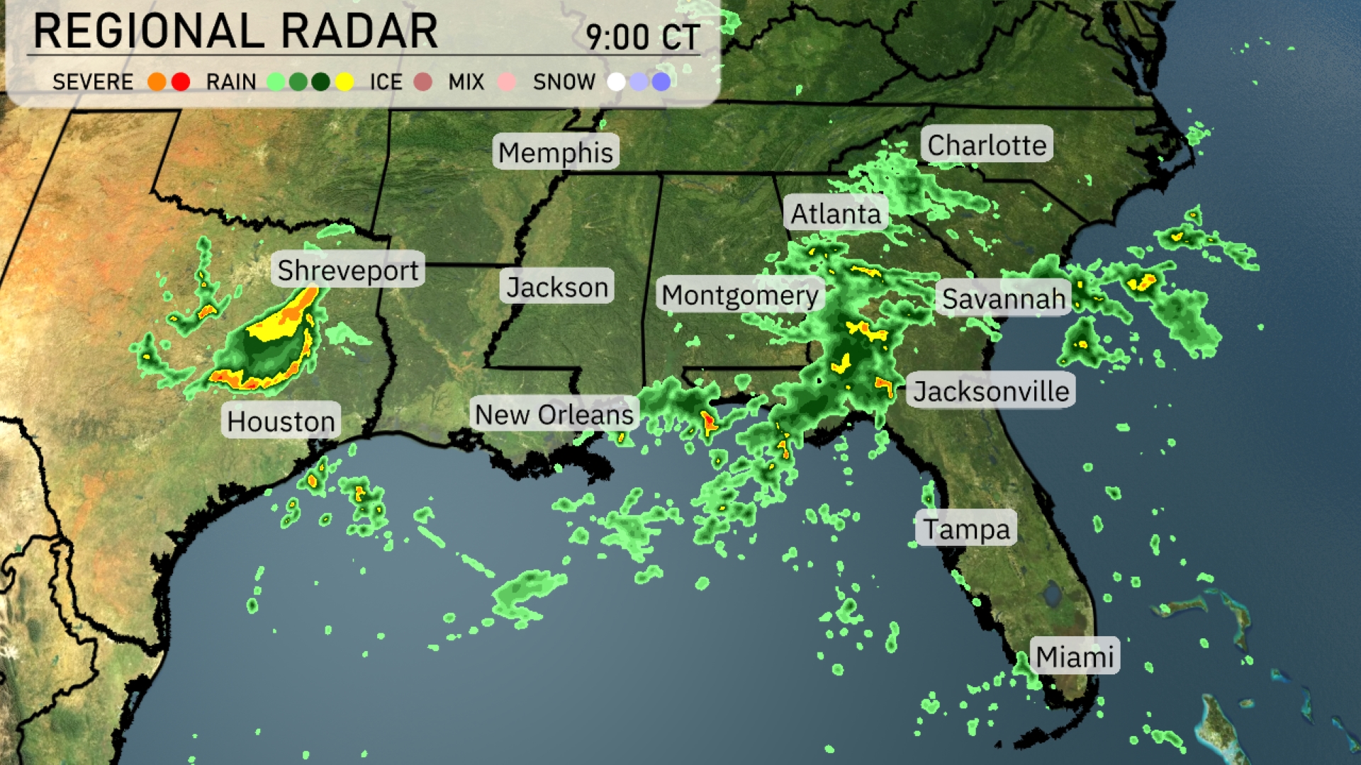
A line of storms is intensifying as it moves from Houston towards Shreveport, bringing severe weather conditions to those areas. Heavy rain is sweeping northeast through Jackson, towards Montgomery and into Atlanta, with significant cloud cover accompanying the precipitation. Farther south, scattered showers are observed moving across southern parts of Georgia towards Jacksonville. Areas like Miami and Tampa remain relatively clear.
Begin your Monday morning in Miami with temperatures around 84 degrees at 8 AM, under partly cloudy skies. As the morning progresses, expect temperatures to rise to 87 degrees by 10 AM, with a light southeast wind at 6 miles per hour. By midday, temperatures will reach 89 degrees, with only a few clouds and an enjoyable southeast breeze at 7 miles per hour.
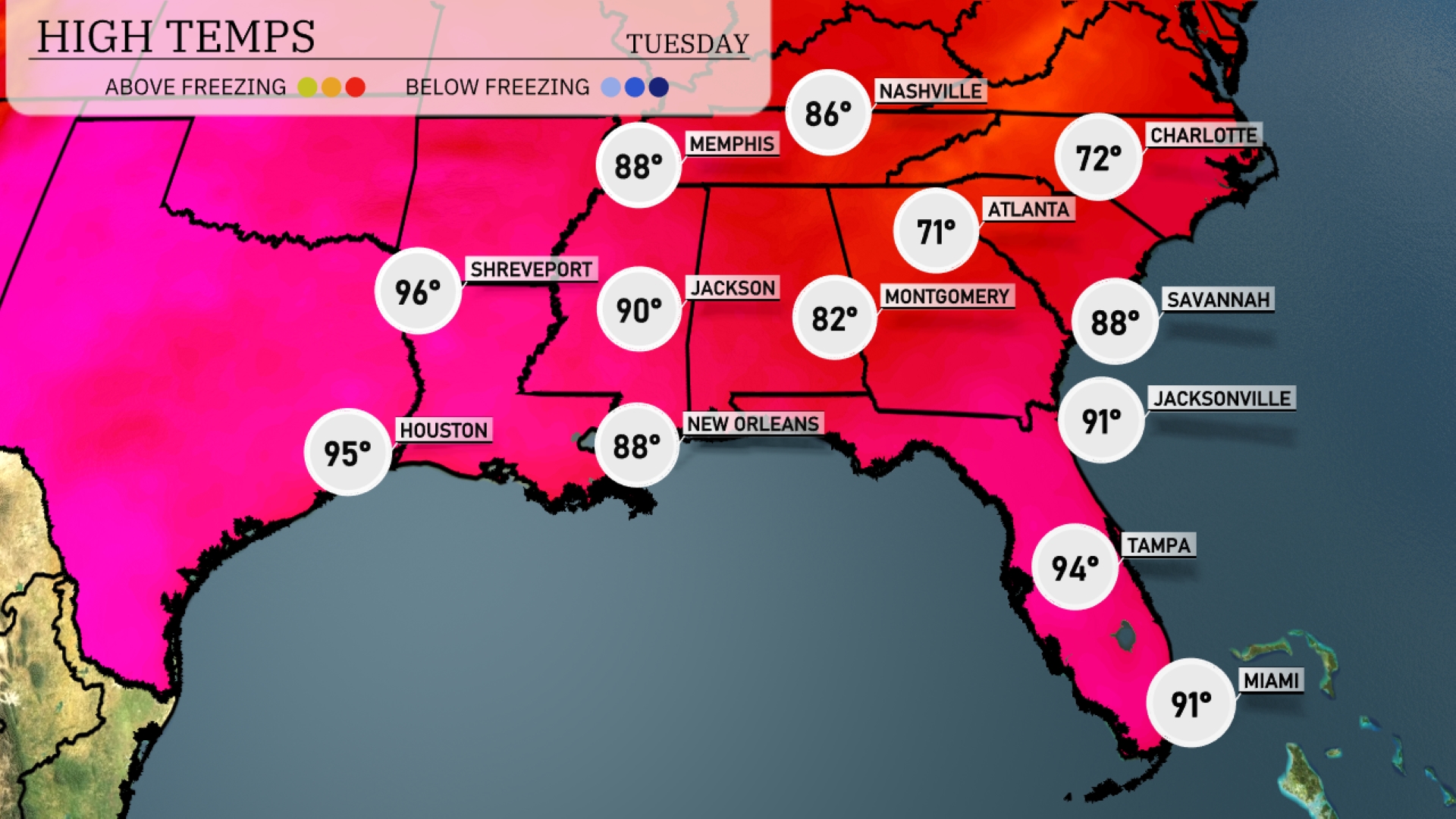
Tomorrow in the Southeast, Atlanta will reach a comfortable 71 degrees, while Nashville warms up to 86 degrees. The heat is significant in Florida, with Jacksonville hitting 91 degrees and Tampa close behind at 94 degrees. Expect steamy conditions in New Orleans as well, with a high of 88 degrees. Over in Mississippi, Jackson is forecasted to reach 90 degrees, indicating a trend of warmer-than-average readings throughout the region.
A cold front will bring widespread showers and thunderstorms across the Southeast on Wednesday morning. From New Orleans to Jackson, expect heavy rainfall and potential thunderstorm activity. By the afternoon, this weather system reaches Atlanta, with isolated severe storms possible, bringing strong winds and heavy rain. Jacksonville and Savannah will see rain as the front moves eastward into Wednesday evening.
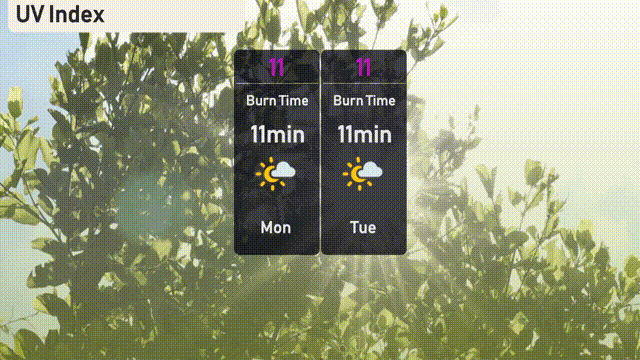
The UV index in Miami will be extremely high on both Monday and Tuesday, with a value of 11, indicating a rapid burn time of about 11 minutes.
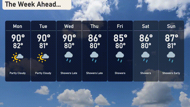
For the 7-Day Forecast in Miami:
Monday: Partly cloudy with a high of 90 degrees and a low of 82 degrees.
Tuesday: Similar to Monday, partly cloudy skies with the high reaching 90 degrees and the low around 81 degrees.
Wednesday: Showers arrive late, with temperatures climbing to 89 degrees, cooling down to 80 degrees at night.
Thursday: Expect showers, with a high of 86 degrees and a low of 80 degrees.
Friday: Continued showers with the high peaking at 85 degrees and the low at 80 degrees.
Saturday: More showers throughout the day, with temperatures reaching 86 degrees during the day and a low of 80 degrees at night.
Sunday: Showers early in the day, giving way to clearer skies, with a high of 87 degrees and a low of 81 degrees.