Morning Glory: Miami’s Clear Skies & Southeast’s Weather Drama
By
Amy Freeze
Explore the contrast between Miami's serene morning and the lively weather patterns affecting the Southeast, from thunderstorms to sunny highs.
Kick-start your day with Miami’s promising forecast while bracing for an active weather day across the Southeast.
Welcome to your weather update for Miami and the Southeast as of July 21, 2025. Miami residents can expect to enjoy mostly clear skies and warm breezes tomorrow morning, making it an ideal start to the day. Meanwhile, a stark contrast exists as parts of the Southeast like Jacksonville and Tampa are under siege by strong storms, with potential flooding alerts. Stay informed on how the weather could impact your day by tuning in to our in-depth analysis and future forecasts.
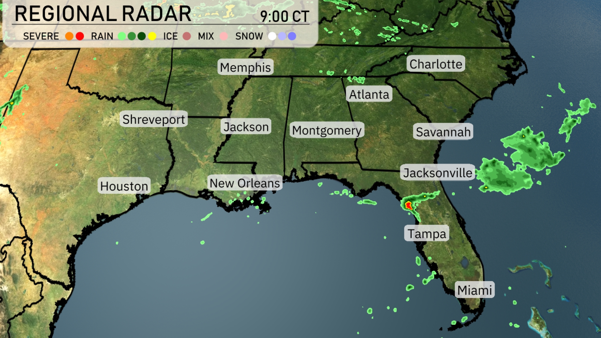
A line of strong storms is pushing across northern Florida, bringing heavy rainfall to areas like Jacksonville and Tampa. Spotty rain showers are also impacting New Orleans and moving eastward into Mississippi. Charlotte and Atlanta are witnessing some cloud cover, but remain dry at the moment. Scattered showers are also evident near Houston, indicating the potential for light rainfall in the vicinity.
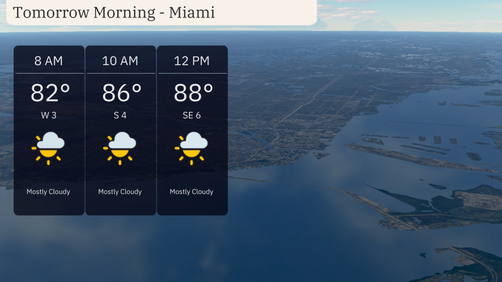
Tomorrow morning in Miami kicks off with temperatures starting at 82 degrees and rising to 88 degrees by noon. Clouds will be mostly present, bringing a partly cloudy start to the day. Wind speeds transition from a light 3 mph from the west at 8 AM to a gentle 6 mph from the southeast by 12 PM. Expect a warm and slightly breezy morning under a predominantly cloudy sky.
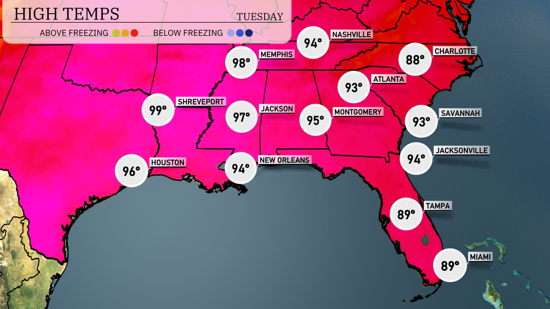
Tomorrow, Shreveport will hit a scorching 99 degrees, while Houston is expected to reach 96. Jackson isn’t far behind at 97 degrees, and temperatures in New Orleans will peak at 94. Montgomery will see a high of 95, and Atlanta will touch 93 degrees. Across the region, these temperatures are well above average, driven by a strong ridge of high pressure influencing the weather pattern.
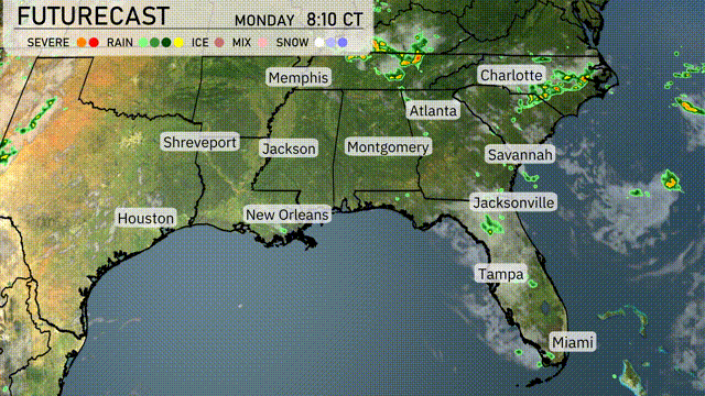
On the futurecast, a weather shift is on the horizon for the Southeast. A cold front currently over Louisiana and Mississippi brings scattered thunderstorms and the potential for heavy rain into Atlanta and Charlotte by tomorrow evening. Expect a weather pattern change in New Orleans and Jackson tonight with growing chances for severe thunderstorms. Showers stretch from Nashville to Tampa, focusing on instability along the front. Be prepared for possible localized flooding as rainfall accumulates quickly over the next 24-48 hours, particularly in areas from Montgomery to Jacksonville.
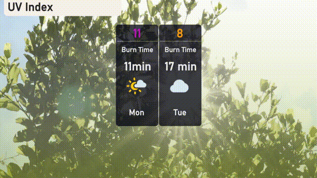
The UV index in Miami is expected to reach a very high level of 11 on Monday, where you’ll need just 11 minutes for a burn in direct sunlight. On Tuesday, the UV index decreases slightly to 8, with a burn time of 17 minutes. It’s a good idea to wear sunscreen and protective clothing to minimize sun exposure risks!
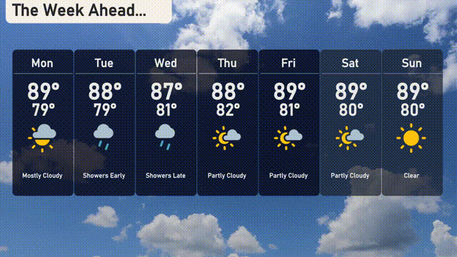
Monday: Start with mostly cloudy skies, reaching a high of 89 degrees and a low of 79 degrees.
Tuesday: Expect early showers, with temperatures peaking at 88 degrees and dropping to 79 degrees overnight.
Wednesday: Look for late showers with a high of 87 degrees and a low near 81 degrees.
Thursday: Partly cloudy conditions throughout the day with a high of 88 degrees and a low of 82 degrees.
Friday: Enjoy partly cloudy skies with a daytime high of 89 degrees and a nighttime low of 81 degrees.
Saturday: Partly cloudy once again, with a high of 89 degrees and a low of 80 degrees.
Sunday: Clear skies to finish off the week, with temperatures soaring to 89 degrees during the day and cooling down to 80 degrees at night.