Sunrise to Storms: Your Comprehensive Southeast Weather Guide
By
Amy Freeze
Catch the latest weather updates from Meteorologist Amy Freeze, covering everything from serene Miami mornings to the storm-studded afternoons across the Southeast. Stay ahead of the weather!
Meteorologist Amy Freeze details the evolving weather conditions in Miami and the Southeast, ensuring you remain prepared for everything from sunny days to stormy afternoons.
Join Meteorologist Amy Freeze as she guides you through the diverse weather scenarios unfolding across Miami and the broader Southeast. From detailed morning temperatures in Miami to storm forecasts in New Orleans and beyond, our blog equips you with all the necessary updates to plan your days effectively. Dive deeper into the daily variations, humidity impacts, and prepare for the week ahead with our in-depth 7-day Miami weather outlook.
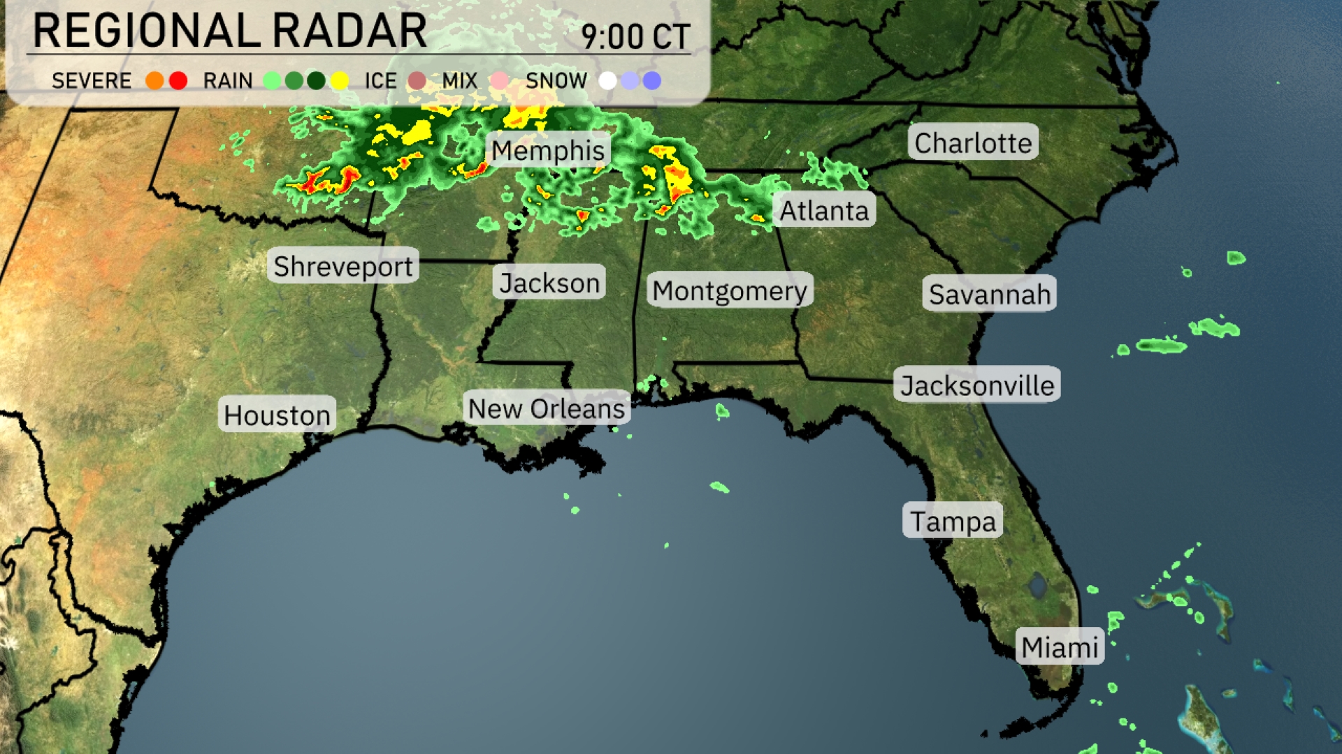
A line of storms is advancing across the Southeast, with Memphis experiencing severe weather. Jackson is seeing heavy rain that continues to progress northeast towards Atlanta. Showers are moving through New Orleans and Houston with persistent cloud coverage. As precipitation stretches into western Georgia, Montgomery is also feeling light showers. Coastal areas remain calm around Savannah and Charleston, enjoying a break from the rain.
Tomorrow morning in Miami, temperatures will start at 83 degrees at 8 AM with mostly sunny skies and an east-southeast wind at 9 miles per hour. By 10 AM, expect a temperature of 85 degrees with partly cloudy skies and a wind from the east-southeast at 11 miles per hour. Moving towards noon, the temperature will rise to 87 degrees, returning to mostly sunny conditions with an east-southeast breeze continuing at 11 miles per hour.
Tomorrow Atlanta will reach a pleasant 81 degrees, while Montgomery also warms up to 89 degrees. Down in Louisiana, both Jackson and New Orleans are set for highs of 89 degrees, indicating a warm and muggy day. In Florida, temperatures are climbing into the low 90s; Jacksonville and Tampa are expected to hit 91 degrees and 91 degrees, respectively. With high humidity contributing to the heat, residents should prepare for a balmy day across the region.
Saturday’s weather in the Southeast looks active with scattered thunderstorms, particularly over Jackson and New Orleans. Expect heavy downpours and gusty winds through the afternoon, which could impact travel. The system isn’t anticipated to intensify to severe limits, but keep an eye on weather developments. By evening, showers extend toward Jacksonville and Miami with isolated pockets of rain. Temperatures will remain warm, especially as the storms clear later in the day.
The UV index in Miami is expected to reach a very high level of 11 both Saturday and Sunday, with a burn time of just 11 minutes in direct sunlight.
Here’s the 7-day outlook for Miami:
Saturday: Partly cloudy skies with a high of 87 degrees and a low of 81.
Sunday: Similar conditions with partly cloudy skies, expect a high again of 87 degrees and a low of 80.
Monday: Another partly cloudy day with temperatures peaking at 87 degrees and dropping to 80 overnight.
Tuesday: Continuation of partly cloudy weather, with a high of 87 degrees and a low of 80.
Wednesday: Mostly sunny and a tad warmer, reaching a high of 88 degrees, with a low around 80.
Thursday: Back to partly cloudy, with a high of 87 degrees and a low of 79.
Friday: Watch for isolated thunderstorms, as the temperature reaches 87 degrees, then cools to 79 at night.