Navigating the Weather Map: Warm Mornings and Stormy Horizons in Miami & Southeast
By
Amy Freeze
Discover how Miami's gentle morning will turn into a bustling weather front as storms sweep across the Southeast. Stay updated with our comprehensive forecast.
Partly cloudy skies, gentle winds, and a surge of storms tracking across the Southeast set the stage for an engaging weather day in Miami. Dive deep into tomorrow’s specifics in our latest blog post.
As Miami wakes to a mild 81°F under partly cloudy skies, the Southeast braces for a wave of weather changes. From mild mornings to intense evening storms, we explore the impact across the region. Stay tuned for strategic insights on how to navigate these shifts, the detailed seven-day forecast, and safety tips during extreme UV levels. Visit our full blog at https://amyfreeze.ai/ for more information.
On the Regional Radar, a line of storms is tracking across the Southeast, bringing intense weather from Memphis to Jackson. Charlotte is beginning to experience increased cloud cover as rain approaches from the west. Thunderstorms are sweeping into Montgomery with significant rain expected. Savannah and Jacksonville remain clear for now, but showers are developing over the Gulf, hinting at potential changes in the coming hours.
Tomorrow morning in Miami, look for partly cloudy skies with temperatures starting at 81 degrees at 8 AM. Winds will gently increase from east-northeast at 4 miles per hour to a steady east breeze at 9 miles per hour by noon. Expect temperatures to rise to 85 degrees by 10 AM and reach 86 degrees by midday.
Tomorrow in the Southeast, high temperatures are expected to soar. Shreveport will reach a sizzling 97 degrees, while Jackson and New Orleans will both see highs around 91. Memphis isn’t far behind, hitting 94 degrees, and Montgomery’s temperature will top out at 92. Coastal cities like Jacksonville and Tampa are looking at highs of 90 and 90, respectively, with Miami slightly cooler at 88.
A cold front positioned across the Southeast is set to bring scattered thunderstorms from eastern South Carolina down through Jacksonville, Florida, with locally heavy rainfall expected. The risk of severe storms includes possible gusty winds and high-intensity downpours impacting the morning commute around Charlotte and Savannah. Showers persist into Thursday evening from Montgomery to Savannah, potentially causing localized flooding in areas of prolonged precipitation. As the front moves eastward, expect drier and cooler conditions to prevail by Friday afternoon, with temperatures dropping to the low 80s across the region. Continue monitoring forecasts for any updates on possible severe weather alerts.
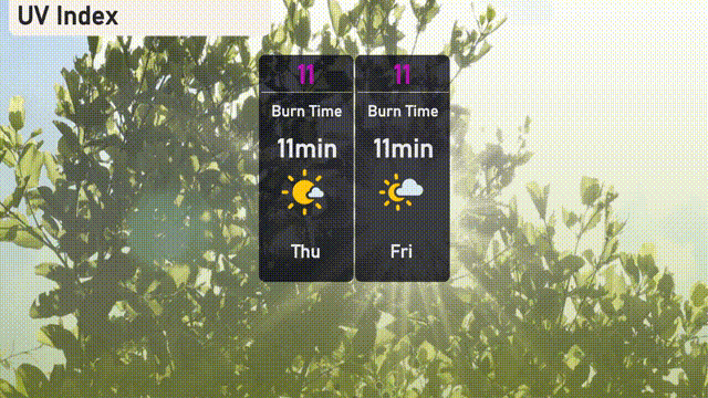
The UV index in Miami will reach an extreme level of 11 on both Thursday and Friday, indicating a burn time of just 11 minutes in direct sunlight.
Here’s the 7-day forecast for Miami:
Thursday: Partly cloudy skies with a high of 87 degrees and a low of 78 degrees.
Friday: Expect showers later in the day, with temperatures reaching up to 87 degrees and a low of 79 degrees.
Saturday: Mostly clear, warm, and sunny, with a high of 86 degrees and a low of 81 degrees.
Sunday: Partly cloudy conditions, with a high reaching 86 degrees and an overnight low of 80 degrees.
Monday: Partly cloudy again, temperatures rising to 87 degrees and cooling to 80 degrees at night.
Tuesday: Sunny spells mixed with clouds, the high will be 86 degrees, and the low is 79 degrees.
Wednesday: Wrap up the week with partly cloudy skies and temperatures hitting a high of 85 degrees, dipping to a low of 79 degrees.